|
|
|
B22
|
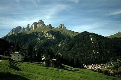
Passo Pordoi » Rifugio Contrin
|
|
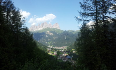
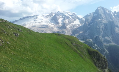
Part of the trail winds over a lava deposit in the heart of the Dolomites, following the historic trade routes to the Veneto region. The descent into Penìa and the subsequent climb to the Contrin hut illustrates the history and culture of the Ladine people. It is a long stage but not a hard one considering that none of the trail is steep.
Detailed route description

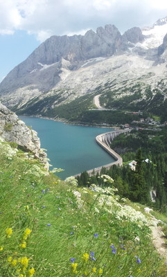
From the Pordoi pass, follow trail 601 (Alta Via trail no. 2) that begins near the Italian Alpine Club building and the Savoia hotel. Follow a broad trail southwards along the eastern bank of the Sas Becè stream, up to a grassy plain and a pass, turning left to reach the Fredarola hut. From this point onwards follow the Viel dal Pan trail (601; Alta Via trail no.2) eastwards, across the southern slope of Mount Sasso del Cappello. The trail cuts across virtually horizontally, about halfway up, along the fields that are typical of this lava formation. At the Viel del Pan hut, follow the obvious trail that encircles the entire Marmolada area. At the fork, (left to Porta Vescovo), take the trail on the right towards the Fedaia dam. Initially the trail cuts across diagonally (there is another turnoff to Porta Vescovo at the end), and then, it is steep and winding. The last part requires particular caution. Once at the road and the Castiglioni hut, take the trail marked 605. It passes under the huge wall of the dam and then bends westwards, crossing under the hut, and then turns east definitively. Follow the track past the Col Ciampié hut. After a steep section the trail leads to the Villetta Maria hotel. Cross the car park and take the narrow street there and then turn left almost immediately along a wide track that heads down through woods and then across open fields. Stick to the main trail and it will lead to the main road. Cross the road just after the guard rail. Then turn right into the woods. The trail here is initially winding but not steep. It then becomes steeper and leads back onto the main road. Keep to the right of the road. Walk on past a religious book shop and a fountain near a solitary house. Cross over, cut through a children’s playground to an old Venetian wood mill at Penìa. Follow the pavement briefly and turn left down a hill that bends quickly right along a narrow strip of woodland between the river and the road. A makeshift bridge crosses the river. Turn right again. Upon nearing another makeshift bridge, keep to the left and follow the signs for trail 602A which leads to the road from Alba up to the Contrin valley. The road is initially very steep. It runs past the Locia Contrin hut and into the Contrin valley with its amazing alpine views. Cross a bridge and the trail heads upwards again to the ridge where the Contrin hut sits at the feet of the Marmolada range. Alternative: from the Castiglioni hut, follow the dam to the War Museum near the cable car station. Follow trail 606 or alternatively take the cable car to the Pian dei Fiacconi hut. Continue to follow the signs for trail 606 as it turns west towards Mount Gran Vernel and leads to the valley that climbs towards the Forcella Marmolada pass. At the pass, reached by negotiating a long stretch of snow and ice, the trail goes down the southern slope. Initially the trail is fitted with guide ropes. Then along a scree slope and west to the Contrin hut.
From the Contrin hut, follow the road (marked 602) almost to the bottom of the valley. Then take trail 602A to the right, towards Penia. Near a makeshift bridge, keep right, following the signs for trail 605, which leads to a games ground. Climb to the road and take the trail that turns left just before the bridge over the Avisio stream. Follow the trail through the woods, along the banks of the river, to the next bridge. Then take the track on the right to the hotel Villetta Maria. Take the trail on the left (marked 605) up to the Castiglioni hut. Cross the road and follow trail 601 of the Viel dal Pan trail. This leads all the way to the Fredarola hut and then down to the Pordoi pass.
(Provincia Autonoma di Trento)
Natural and cultural heritage
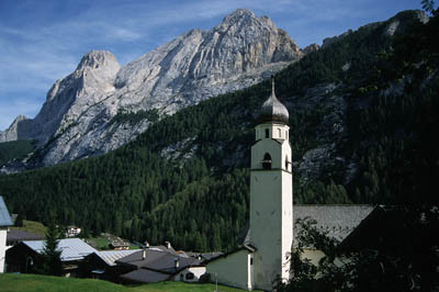
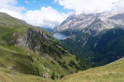
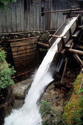
Walking through the harsh environment that is typical of volcanic sites there is rich vegetation to be seen, grasses that are characteristic of the area. From a geological perspective it is interesting to note the contrast between igneous and dolomitic rocks and the different geomorphological types. The artificial lake of Fedaia is also interesting in that it feeds the hydroelectric power plant at Malga Ciapela in the Veneto region. Near the Seggivoia Marmolada hut there is a museum devoted to World War I and the Marmolada area. Another point of note is the via cruces (way of the cross) at Pian Trevisan and the Church of the Crucifix at Fedaia. At Penia there is a Ladin open-air museum with a Venetian water-powered saw mill in full working order.
(Provincia Autonoma di Trento)
Other long-distance trails and alternative routes
Alta Via no. 2, “Sentiero Italia”.
Variant Alta Via n. 2: Castiglioni Hut - Pian dei Fiacconi Hut - F.lla Marmolada – Contrin Hut (signposted 606).
Climb to the top of Mt. Penia along Via ferrata della Marmolada.
Useful topographic maps
-
06 ~ Tabacco (1:25.000)
-
686 ~ Kompass (1:25.000)
-
8 ~ Lagiralpina (1:25.000)
Useful guidebooks
-
"Trentino Orientale", Achille Gadler (2000) ~ Panorama (ISBN )
-
"Val di Fassa", Fabrizio Torchio e Enzo Gardumi(1996) ~ Kompass-Fleischmann (ISBN )
-
Via Alpina Gelber Weg, Evamaria Wecker ~ Bruckmann (ISBN 978-3-7654-4858-7)
Websites relative to natural and cultural heritage
Last update : 2009-12-03

 |
7h10 |
17.5 km
|
1867 m
|
2091 m
|
7h10 |
17.5 km
|
1867 m
|
2091 m


Favourites, criticisms ? Make your personal comments on this stage. For more general notes please use the comments section of the page Over to the Via Alpinists.