Hiking (mountain trail, in places narrow and exposed)
Alpine route (equipped or very exposed section, snow field, blocks)
A55
Kreuth » Lenggries
|
7h50 |
25.5 km
|
1232 m
|
1333 m
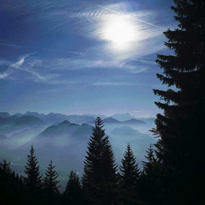
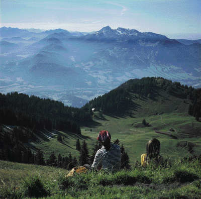
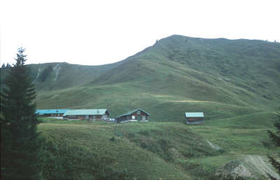
The stage from Kreuth to Lenggries is relatively long but also very beautiful and promises some good views. Long stretches of the hike lead through woodland, and you will enjoy a rest at the Hirschberghaus lodge and the fresh water of the Schwarzenbach stream. The Seekarkreuz offers some wonderful views before hiking onwards through the Hirschbach valley to Lenggries.
In Kreuth, walk for a short distance along the main road towards the north to the town hall. The marked trail to the Hirschberg starts here on the other side of the street. It heads steadily through beautiful mixed forest uphill until reaching a forest trail after crossing a stream. Follow this trail for a short while. Several hundred metres before the Gründ Hut, a footpath branches off to the left, soon climbing up over often marshy clay earth until the trail changes to the other side of the valley and arrives at a forest trail. Follow it upward to the Rauheckalm meadow (pass between the Rauheck foresummit and the eastern summit of the Hirschberg). Cross below pines to the northern ridge of the Hirschberg. Now head briefly downhill (right, to the north) to the Hirschberghaus lodge. From the ridge, you can turn left to arrive at the Hirschberg peak in a few minutes (approx. 20min), which offers a particularly lovely view over the rest of the day’s stage. As there are no trails leading directly from the Hirschberg to the Almsattel pass near the Schwarztennalm meadow, you must double back to the Rauheckalm meadow. Here, a narrow path turns off on a very gentle decline along the slope below the Hirschberg peak to the Weidbergalm meadow. A track starting at the meadow leads downhill to below a wide pass. Turn to the right. The trail leads onto the Almsattel pass at the Schwarztennalm meadow. Service facilities are offered at the Schwarztennalm (no accommodation but simple Bavarian cuisine). In the valley, turn left (south) and walk for a few hundred metres before reaching the Schwarztennalm meadow, where a forest trail leads uphill to the right (sign for Seekarkreuz/Lenggrieser Hut). After a short distance, leave the trail to the Gurnbach waterfall and continue on a footpath first through woodland and then across pastureland (pay attention to the trail and markings, sometimes hard to distinguish) to the Raualm meadow. A pasture trail starts here and leads to the pass between Brandkopf and Seekarkreuz. Now take the footpath slightly to the left over the grassy ridge to the Seekarkreuz (1,601m). Head along the ridge down to the next hollow and then follow the clearly signed route to the right (north west) down through woodland to the Lenggrieser Hut (rest day on Tuesday). A path from the hut leads northward to the Seekaralm meadow and, keeping to the left, continues down through the wood to the Stickelalm meadow. Here, keep to the left in a westward direction, following the forest road and later the road out of the valley to reach Lenggries. From Lenggries, walk along the Hirschbach stream into the valley and finally turn right to the Lenggrieser Hut. (Michael Kleider, Martin Scheib, DAV-Tegernsee)
Natural and cultural heritage
From the summit of the Hirschberg (also from the foresummit, which can be reached from the Hirschberghaus lodge in 5min), it is possible to gain an informative insight into the cultural landscape of the Tegernsee valley, which exists due to a smaller, local glacier (the Tegernsee glacier). This glacier had only very little influx from the Central Alps, which is why the glacier tongue left behind a moraine directly on the alpine periphery at Gmund – which can be viewed not far into the prealpine region, near the Ammersee and Starnberger lakes for instance. In the Tegernsee–Schliersee area, molasse, Helvetic nappe and flysch accompany the alpine limestone from the Triassic and Jurassic periods. These hard, light-coloured limestone rocks that were created in the Mesozoic era as sediment on the flat sea-bed are what form the rather sheer rock faces of the Tegernsee and Schliersee mountains. While at the Hirschberg summit you are still standing on Triassic rock, this is joined to the north by a zone with Jurassic limestone, until the mountains with the roundish forms of the flysch zone (mighty nappe series of clay and sand, created in the Cretaceous period and in the Tertiary period as soft sediment strata on the deep sea-bed) and a narrow strip of the Helevetic nappe (likewise soft sediment from the Cretaceous period) sink into the prealpine region. This is where the molasse zone joins on. Molasse means “soft stone” and describes sediment that was worn down during the orogenesis of the growing Alps and carried by rivers into a deep sedimentation trough. Here, the material was able to harden and this created conglomerates and sandstone. Thus, the landscape contrasts (sheer rock faces/rounded landscape forms) can be explained by the transition from hard limestone to the predominantly soft, easily weathered rocks of flysch, Helvetic nappe and of the molasse zone, which joins on from the north. Before the Isar river leaves the mountains, it flows through the Isarwinkel (Isar corner) region. The middle point of this wide valley is Lenggries. Joseph Friedrich Lentner (he travelled through Bavaria, commissioned by the Bavarian Crown Prince and later King Maximilian II of 1846-1851, to compile an ethnographic report on the land for the prince) wrote the following of the Isar valley: “A friendly, well developed front valley coming up behind Lenggries with a beautiful high plateau (..). Lenggries stands impressively and comfortably on the broad gravel beds of the river.” And Lentner then went on to write about the inhabitants and their houses: “A fine and beautiful people live on the banks of the Isar, tall and well-built. Mostly of regular features, the men more handsome than the women, agile, strong and persevering... In the villages as well as in the separate dwellings there are mainly beautiful and extremely neat and very well decorated houses built according to ‘mountain style’.” Lenggries and its surroundings have doubtlessly lost some of their cosiness since they became a skiing dorado and hiking paradise, but the beautiful façade paintings on many of the private and public buildings have remained. (Michael Kleider, Martin Scheib, DAV-Sekt. Tegernsee)
Other long-distance trails and alternative routes
short detour to the Gurnbach waterfall (after the Schwarzenbachtal valley, leave the trail to the right); you do not necessarily have to stop at the Hirschberghaus lodge. Instead, it is possible to turn off to the left beforehand to come back onto the Purple Trail of Via Alpina at the Weidbergalm meadow.
Useful topographic maps
Bad Tölz-Lenggries-Tegernsee (UK L18) ~ Bayerisches Landesvermessungsamt München (1:50000)
Nr. 8 Tegernsee -Schliersee -Wendelstein ~ Kompass (1:50.000)
ÖK 50 88, 87 ~ Bundesamt für Eich- und Vermessungswesen (1:50.000)
Useful guidebooks
Bayerische VoralpenOst ~ Rudolf Rother, München (ISBN 3-7633-1120-3)
Favourites, criticisms ? Make your personal comments on this stage. For more general notes please use the comments section of the page Over to the Via Alpinists.

 |
7h50 |
25.5 km
|
1232 m
|
1333 m
|
7h50 |
25.5 km
|
1232 m
|
1333 m


Favourites, criticisms ? Make your personal comments on this stage. For more general notes please use the comments section of the page Over to the Via Alpinists.