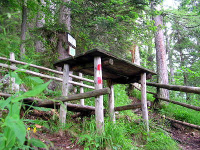
Hiking (mountain trail, in places narrow and exposed)
Alpine route (equipped or very exposed section, snow field, blocks)
A27
Zellerhütte » Hinterstoder
|
3h35 |
13.4 km
|
143 m
|
1073 m
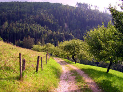
The descent to Vorderstoder starts off rather steep, but the mountain panorama makes up for all your efforts, for the Vorder- and Hinterstoder communities lie at the foot of the colossal Priel and Sensengebirge mountain ranges..
From the Zeller Hut, start off through the wood, still on a very steep descent. However, the “Gott sei Dank” (thank goodness) and “Halbzeit” (half-time) benches will invite you to take a rest. Through the trees, repeated views over the Spitzmauer and the Großer Priel can be snatched, which only heightens the anticipation of the coming day. After some pleasant, even terrain along the sloping ridge, you will finally reach the valley station of the goods lift and a forest path. After only a few metres, however, you will see the turn-off to the left into the woods. At the Hof Binder farm, leave the wood and reach the estate after a short stretch over the sheep pasture. Walk between the farm buildings and turn right onto the roadway to reach the asphalt road, where you must keep to the left. After a downhill walk, the mountain bike trail branches off left, and this could also be followed in the direction of “Baumschlagerberg”. However, Via Alpina follows the signposting between the buildings of the farm downhill through the meadow to the lift support structure, where it crosses the little bridge and continues briefly uphill through the meadow until directly reaching the little village of Vorderstoder (approx. 1h45min). Following the main road, go to the “Stockergut” estate, where you must follow trail no. 8 to the left. A small track leads downhill, crossing the road and meeting it again at the hairpin bend. But just afterwards, it turns left onto a track leading further downwards, across a little wooden bridge and then onto an asphalt road down to the left to the “Huttererseite” area. Keeping to the right, you will reach a gravel path which must be followed between the farm buildings and taken downhill through the woodland. Cross an asphalt road twice, then take the forest road for a short, steep uphill climb and finally keep to the right again on even ground until reaching the Hof Wartegg farm. Turn down towards the right on a meadow path until reaching the asphalt road. A steep walk along the latter leads to the first houses of Hinterstoder. At the first turn-off, keep to the left in the direction of the Gasthof Gressenberger inn. Head right through the garden, following the signposting for “Ort” to reach a little track leading directly onto a descent to the main road to Hinterstoder and to the “Poppenberger” Europa Wanderhotel (hikers’ hotel). After approx. 15min on the road, you will reach the village of Hinterstoder. At the “Poppenberger” Europa-Wanderhotel, turn to the right and, keeping to the left, come onto the track to the Gasthof Gressenberger inn. There, continue straight ahead and turn right uphill to the Hof Wartegg farm. From here, follow the signposting in the direction of Vorderstoder, where a meadow path just after the church will lead down to the stream. Cross the stream and walk upward over the field on the other side. This is where the climb to the Zeller Hut begins. (Christina Schwann, OeAV)
Natural and cultural heritage
Hinterstoder lies in the spring area of the Steyr river at the foot of the Große Priel (2,514m) and the Warscheneck foothills. The Stodertal valley is a distinctive glacial cirque which maintained its current form through the force of the glacier during the last Ice Age. The valley is scattered in many different places with projecting, almost level-surfaced mountain ridges, sloping terraces or beautiful flat meadowland several hundred metres above today’s valley floor. These are the remains of a pre-Ice-Age valley floor that was 200 to 300m higher than today’s. The name "Stoder" comes from the Slav word for “cold” or “stony earth”. In about 770, the valley was in fact occupied by Slavs, and the Traun river formed the border between the German-speaking area and Slovenia. In the 11th century, the entire valley floor of Windischgarsten with the surrounding mountain ridges was owned by the Bishopric of Bamberg, donated by Emperor Heinrich II in the year 1007. This led to the establishment of the monastery and the dominion of Spital am Pyhrn. The main purpose of the monastery was to shelter pilgrims on their way to the Eternal City of Rome or Aquileja, from where the crusaders embarked on their arduous journey to the Holy Land. Hinterstoder, which had not been spared from the wars and had experienced an influx of refugees, also for a time suffered from great poverty. Nevertheless, the community continued to develop: in 1787, Hinterstoder received its own parish priest, in 1874 a post office, in 1894 a telegraph connection and in 1909 a telephone line. The progressive extension of the Stodertal provincial road began at about the turn of the century and this also marked the start of tourism in the valley. Skiing started there in about 1910, although initially this was above all practiced for practical purposes by local hunters and foresters. The first skiing World Cup races were held in 1986 in Hinterstoder, which brought a major tourist boom to the community and in 1998, Hinterstoder was even included on the list of “European village renewal communities”. Today, visitors to the Alpineum can experience the history of skiing from the early days through to the present. (Christina Schwann, OeAV)
Other long-distance trails and alternative routes
north alpine trail 01, European long-distance trail E4, crossroads with the Salzsteigweg (salt trail) 09.
Useful topographic maps
WK 082, Totes Gebirge ~ Freytag&Berndt (1:50.000)
15/3, Totes Gebirge, Ost ~ Oesterreichischer Alpenverein (1:25.000)
Nr. 19 Almtal, Steyrtal, Totes Gebirge ~ Kompass (1:50.000)
ÖK 50 98 ~ Bundesamt für Eich- und Vermessungswesen (1:50.000)
Favourites, criticisms ? Make your personal comments on this stage. For more general notes please use the comments section of the page Over to the Via Alpinists.

 |
3h35 |
13.4 km
|
143 m
|
1073 m
|
3h35 |
13.4 km
|
143 m
|
1073 m


Favourites, criticisms ? Make your personal comments on this stage. For more general notes please use the comments section of the page Over to the Via Alpinists.