Hiking (mountain trail, in places narrow and exposed)
Alpine route (equipped or very exposed section, snow field, blocks)
A26
Spital am Pyhrn » Zellerhütte
|
8h35 |
18.3 km
|
1698 m
|
777 m
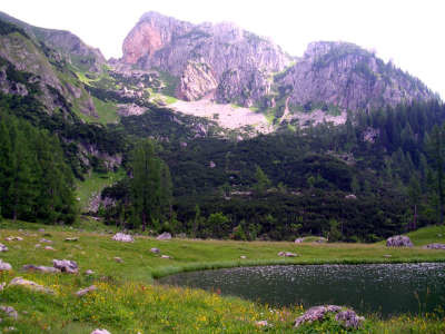
In addition to the newly established water theme trail on the way from Spital am Pyhrn to the valley station for the funicular railway, the Wurzeralm meadow nature reserve and the idyllic Brunnsteiner See lake, this stage also offers a thoroughly high-altitude character over the Toter Mann and possibly also the Warscheneck mountains, where you are guaranteed an outstanding panoramic view.
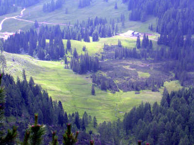
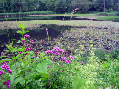
On approaching the village centre of Spital am Pyhrn, follow the signposting for the “Gewässerlehrpfad” (water theme trail) and the Wurzeralm meadow. Follow the main road to the end of the village, where the route continues on a footpath alongside the road until branching off to the right to the water theme trail just after the motorway access road (approx. 30min). Alternatively, you could also travel here by bus or directly to the valley station of the Wurzeralm funicular. Cross the Teichl and continue to the left up the river. Among other things, this newly established and very well signposted water theme trail reveals the secret of the Teichl. Several illustrated charts offer interesting details on the habitats of water, woodland and mountains. After approx. 1h 15min of a leisurely stroll, you will reach the “Pflegerteich”, a magnificent biotope. From the pond, you can already see the valley station of the funicular, which can be reached in several minutes. Alternatively, you can take a relatively steep road to the Wurzeralm meadow from behind the valley station. Next to it there is also a narrow footpath over the wide downhill slope. However, as this stage is rather long and strenuous, you should not begrudge yourself the trip with the funicular (reduced tickets for Alpine Club members, leaving every half hour in the summer months as of 8:30am). From the mountain station, follow the signposting to the right in the direction of the Brunnsteiner See lake. This can be easily reached on a wide, slightly undulating hiking trail in approx. 40 min. From the Brunnsteiner See lake, the trail becomes steeper. A track takes you to the Rote-Wand-Sattel pass left of the impressive Rote Wand mountain in approx. 1h 30min. Here, the 293 AV-trail also branches off to the Dümler-Hut, which is recommended as an alternative to climbing the Warscheneck peak in bad weather, but also for those who may suffer from vertigo. From the Dümler-Hut, there is a connecting path first with trail no. 293, then with no. 290 via the Windhagersee lake to the Zeller-Hut. From the Rote-Wand-Sattel pass towards the North-West (trail 201), the climb only starts as of the “Toter Mann” (dead man). After the first upward stretch, the flat trail follows the sloping ridge that goes steeply down to the left. The view over Windischgarsten and Roßleithen and also the Warscheneck mountain is impressive. The last climb to the “Toter Mann” is very steep and here and there you may need to use your hands (approx. 1h 30min from the pass). From the “Toter Mann”, the approx. 30min climb into Warscheneck (2,388m) is entirely risk-free. The trail leads down to the right (northwards) to the Zeller Hut via the Arbesboden. Here, you can already enjoy the view over the Spitzmauer and the Große Priel. Slowly, the pines become thicker and increasingly padded with undergrowth. The descent to the Zeller Hut finally leads steeply downwards through a sparse larch wood with a great deal of undergrowth (approx. 1h 45min). The uphill trail from the Zeller Hut to the Warscheneck is very well marked. The alternative route for bad weather conditions leads from the refuge eastwards via the Windhagersee lake to the Dümler Hut. (H. Haberfellner, OeAV-Sekt. Linz, Christina Schwann, OeAV)
Natural and cultural heritage
The approx. 3.5km long water theme trail that runs alongside the Teichl river from Spital am Pyhrn to the valley station of the Wurzeralm funicular has eight information boards. Interested hikers read these to learn about the plant and animal world, the geology and the ecological context of their immediate surroundings. This brings you to a very interesting place, namely the valley outflow of the Teichl river. The Teichl is the river that flows on the Wurzeralm area in distinctive meandering loops over the meadows. Its beauty is therefore particularly striking and a walk along the signposted circular trail around the Teichl moorland is perhaps worth while, as the highland moor under nature protection with its numerous watercourses invites hikers on an exploratory trip. A fascinating view over the Teichl moor and the meandering Teichl river can be enjoyed from the Stubwieswipfel (1,786m), which can be climbed in only 1h 15min In the southeastern corner of the high moorland, the Teichl river disappears at an altitude of approx. 1,350m from the surface of the Wurzeralm meadowland. Only about 5km further down, not far from the Pflegerteich pond above the Pyhrn pass road, it springs up from the earth back into daylight again. A sign for the water theme trail points the exact way to the spring outlet and explains this natural phenomena on an information board. The Warscheneck mountain range belongs to the so-called “Tote Gebirge” (dead mountains). However, the Tote Gebirge are anything but dead. Mountain pines (krummholz belt) and weatherproof larches and spruce trees growing at over 2,000m in altitude mark their appearance. The Tote Gebirge range is a limestone massif and displays all of the typical karstic features of scratches, dolines and caves. The evolution history of the northern limestone alps goes back as far as the Mesozoic era. The limestone was deposited in the sea and therefore belongs to the sediment rocks that represent a rarity world-wide. The red, sometimes green “Werfen strata” are among the oldest rock layers that were formed in shallow parts of the sea. Other parts, such as the Sensengebirge mountains, came from a reef. This limestone is called "Wetterstein limestone". The mighty Dachstein limestone was deposited behind the reef towards the coastline in the lagoon. It structures the entire Tote Gebirge range, the Warscheneck massif and the Haller Mauern. Near the southern flank of the Warscheneck, the Dachstein limestone is marked by broad bands and numerous fossils testify to the past in the sea. The large megalodont clams that today look like "cow footsteps" and that are thick-skinned due to the surf, occur with particular frequence. The much sought-after clam rocks, which today can be found in the odd front garden in Windischgarsten, occurred there where the tides washed up the snail shells of the bulbous actaeonella and the long narrow nerinea. (H. Haberfellner, OeAV-Sekt. Linz, Christina Schwann, OeAV)
Other long-distance trails and alternative routes
Alternative route for bad weather from the Wurzeralm meadow via the Dümler Hut to Roßleithen and Vorderstoder, alpine alternative via the Warscheneck- southeastern ridge (trail secured with ropes) northern alpine trail Lake Constance - Dachstein - Neusiedler Lake 01
Useful topographic maps
15/3, Totes Gebirge, Ost ~ Oesterreichischer Alpenverein (1:25.000)
ÖK 50 98, 99 ~ Bundesamt für Eich- und Vermessungswesen (1:50.000)
WK 082, Bad Aussee, Totes Gebirge, Bad Mitterndorf, Tauplitz ~ Freytag&Berndt (1:50.000)
Nr. 19 Almtal, Steyrtal, Totes Gebirge ~ Kompass (1.50.000)
Favourites, criticisms ? Make your personal comments on this stage. For more general notes please use the comments section of the page Over to the Via Alpinists.
Die zmZellerhütte ist eine extrem gut geführte Hütte, gutes hausgemachtes Essen, top Frühstück und suoer Lage mit herrlichem Ausblick
Automatic translation
[Google]
The zmZellerhütte is an extremely well-run hut, good home-cooked food, top breakfast and suoer location with stunning views
Marianne Geets - 2015-08-15
Lohnende variante: Spital - Wurzer Alm (ev. Standseibahn, Bus von Spital zur Talstation) - Hochmölbingerhütte - Tauplitz - Schneckenalm nach Gößl - Altaussee - Loserhütte
Automatic translation
[Google]
Worthwhile Description: Hospital - Wurzer Alm - Hochmölbingerhütte - Tauplitz - Schneckenalm after Gößl - Altaussee - Loserhütte (ev Standseibahn, bus from the hospital to the base station.)
Bergziege - 2012-09-10
Es gibt eine Spitalkarte, dann kostet der Bus und die Seilbahn nichts. Der bus fährt auch am Wochenende.
Automatic translation
[Google]
There is a hospital card, then does the bus and the cable car nothing. The bus runs on weekends.
Via Alpina International Secretariat - 2011-06-16
@Hans Diem: der Unterschied liegt in der Benutzung der Wurzeralm-Seilbahn: dann "spart" man sich in der Tat fast 600 Hm! - Nathalie Morelle, Internationale Koordinatorin Via Alpina
Automatic translation
[Google]
@ Hans Diem: the difference lies in the use of the cable car Wurzeralm: then "save" it in fact almost 600 meters! - Nathalie Morelle, International Coordinator Via Alpina
Hans Diem - 2011-04-26
Ausfstieg nur 1230 Hm, Abstieg nur 920 Hm (nach Buch von E. Wecker).
Automatic translation
[Google]
Ausfstieg only 1230 Hm, Hm descent only 920 (referred to by E. Wecker).

 |
8h35 |
18.3 km
|
1698 m
|
777 m
|
8h35 |
18.3 km
|
1698 m
|
777 m


Favourites, criticisms ? Make your personal comments on this stage. For more general notes please use the comments section of the page Over to the Via Alpinists.