Hiking (mountain trail, in places narrow and exposed)
Alpine route (equipped or very exposed section, snow field, blocks)
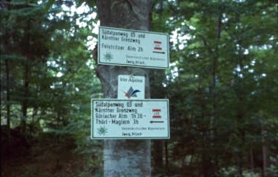
R16
Thörl-Maglern » Feistritzer Alm
|
6h25 |
19.2 km
|
1638 m
|
578 m
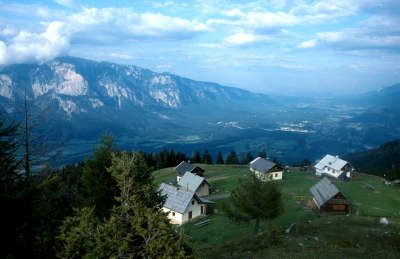
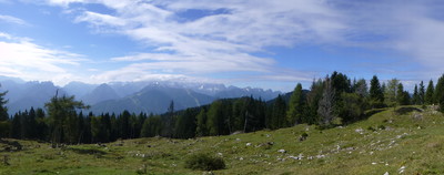
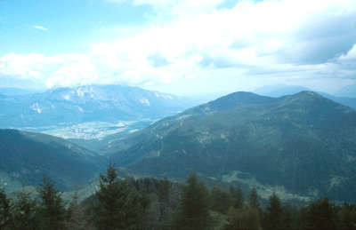
The trail leads along the Austrian-Italian border upwards through a splendid stretch of woodland. The wood again and again opens out onto a view of the western Julian Alps and the Dobratsch in the North. The last section leads across the alpine meadowland of the Achomitzer Alm, Maria Schnee and finally the Feistritzer Alm.
From Thörl-Maglern, the signs on trail no. 403 lead westwards through the village. The clear markings then take you along the forest road, past the local spring-house into the wood. A woodland path that sometimes takes a steep uphill course leads after around an hour’s walk to the Habichtsquelle spring, where a bench invites you to stop and catch your breath. Then continue on to the “Habichtsblick” vantage point (1,298m), located about 50m off the hiking trail to the left. This is a great resting place with a table and walkers’ book, and also offers a first view over the Gailtal valley and the Julian Alps. Now the trail heads northwards along a considerably flatter course past the Kapin (1,530m) and along the forest road, where the houses of the Göriacher Alm meadow soon come into sight. You can reach them after leaving the road by heading over woodland and along meadowland paths. Although trail 403 now turns off to the left, continuing in this direction after passing a spring, a massive church bell from the year 1982 hung beneath a wooden roof attracts the hiker’s attention. It is by all means worth while taking a detour to it, ringing it once and then continuing to the Göriacher Berg mountain (1,693m). After the well, the forest path soon branches off to the right and leads on an almost even course over Italian territory. After approx. 2km, the trail leaves Italy behind and continues along a woodland path for a short climb until arriving just below the summit of the Kapinberg mountain (1,735m). The narrow trail now turns right, then leading downhill after a flat slope crossing on a short but steep descent. The trail soon heads across more level high forest terrain out to the Ochsenstand mountain, and then through dense mixed woods down to the Bartolosattel pass. This border crossing, which was closed until only recently, is now open again. No matter how inconspicuous the crossing may appear to us, it has always played an important role. Now continue westwards again on a gentle upward incline through the wood, first along a path and then taking a forest road with a few sharp bends. Leave the road shortly before a house (meadow). The very steep path follows the border line and eventually crosses horizontally to the Achomitzer Alm meadow. Here the trail turns towards the NW and a small church can be glimpsed on the opposite hill. After a good 30min, the uphill/downhill route brings you to the "Maria Schnee" chapel. Another 10min will also take you to the destination of this stage, the Feistrizter Alm meadow at the foot of the Oisternig (2,052m). (Eckart Promberger, Andreas Fink, OeAV Section Villach, Martin Fürnkranz)
Natural and cultural heritage
The Carnic Alps have been influenced by their geological history, which goes back 500 million years. On the one hand, geological peculiarities of virtually world-wide uniqueness can be found here, while on the other hand numerous war relics that tell of the front-line battles in the World Wars can also be found. This is likewise the case on the Bartolosattel pass. The way to the pass leads from both the Kanaltal and the Gailtal valleys, first through narrow ravines, where in the early settlement days there was only a mule track. The wide valley floor south of the pass offers extensive, verdant pastureland, the ownership of which was the subject of bitter dispute between the inhabitants in the south and the Lords of Wasserleonburg in the north. A wall plaque in the parish church of Feistritz an der Gail even mentions the killing of a Gailtal farmhand by farmers from Saifnitz during the conflict. As the rather discreet pass crossing that was only controlled on a sporadic basis, it was also targeted by smugglers and national fugitives on both sides. The road from the south dates back to the era of Mussolini, but the rocks there were walked across from a much earlier age. This is where Kugy the climbing teacher trained his "Golden Boys" in 1915. In the Bartolograben rift, there is a memorial plaque on which it can be read in Italian that on 7 October 1813, a "cacciatori otto" battalion launched a fierce attack on the troops of Italian Viceroy, Eugen Beauharnais. These were the liberation wars against Napoleon. In the Feistritzer Alm meadow stands the little chapel of "Maria Schnee". The construction of the chapel is closely linked with the hotel on the Feistritzer Alm. In 1911, the hotel was built in the place of an old, walled refuge hut. Tourism thrived there until the start of World War I. The alpine hotel business run as a high-altitude spa was mainly reserved for nobility or wealthy guests. They were brought here to an altitude of 1,722m by carriage along the 12km macadam road. The hotel proprietor, Anton Achatz, had the chapel of Maria Schnee built in late Gothic style to meet the religious needs of his guests. The square in front of the little church, about 10 minutes on foot south of the pastureland, was carefully chosen. From here, it is possible to see the church of Luschari in the Kanaltal valley and that of Feistritz an der Gail. Just below the Feistritzer Alm meadow, the so-called "black fountain” springs up in a rift, surrounded by dark stone. The powerful thrust of this spring, which does not subside even in extreme drought, provides a guaranteed supply for the alpine farms should the water from the upper pasture spring ever not suffice for the people and animals there. (Eckart Promberger, OeAV-Sekt. Villach)
Other long-distance trails and alternative routes
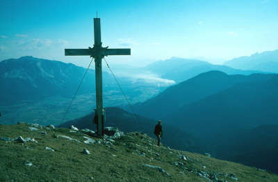
South alpine long-distance hiking trail 03, KGW Carinthian border trail. From the Göriacher Alp, there is a detour up to the summit of the Göriach mountain at an altitude of 1,693m. The almost 10-minute climb is rewarded by a very lovely view over the nearby Julian Alps. From the Feistritzer Alp, the 45-minute to the 2,025m high Osterinig is well worth it.
Favourites, criticisms ? Make your personal comments on this stage. For more general notes please use the comments section of the page Over to the Via Alpinists.
M&M - 2023-09-10
Die Gehzeit beträgt eher 7.30 Stunden als 6.25 Stunden. Wenn es weder auf der Feistritzer Alm noch auf der Dolinza Alm keinen Platz mehr gibt, kann es bei der italienischen Hütte Rifugio Nordio Deffar (Fratelli Nordio) probieren - sie liegt ca. 10min vor der Dolinza Alm abseits der Via Alpina.
flautix - 2023-08-21
Da selten Busse fahren und die Etappe sehr lang ist, haben wir uns am Morgen mit dem Taxi von Arnoldstein nach Oberthörl zum Beginn des Wanderwegs bringen lassen. Sehr schöner Aus- und Rundblick von der Göriacher Alm zurück auf die Julischen Alpen und den Triglav!
Nette Aufnahme und beste Versorgung auf der idyllischen Feistritzer Alm. Martina führt dankenswerter Weise das Erbe ihrer Mutter als Hüttenwirtin weiter, die letztes Jahr bei schlechtem Wetter auf der Rückfahrt von der Hütte ins Tal tödlich verunglückt ist. Die Wirtsleute fahren abends ins Tal: dann ist der Generator aus! Daher Handy etc. vorher laden... WC mit Waschbecken auf der gleichen Etage wie die Schlafräume, keine Dusche. Frühstück wird auf einem Tablett bereitgestellt.
flautix - 2023-06-12
Es gibt jetzt laut Aussage der Gemeinde Freistritz eine neue Pächterin: Martina Collu
Tel: +39 338 802 4020
flautix - 2023-05-09
Die Pächterstelle auf der Feistritzer Alm ist derzeit noch vakant, so dass man auch nicht reservieren kann. Ab ca. Mitte Juni 23 gibt es hier weitere Auskünfte:
Gemeinde Feistritz an der Gail
Feistritz an der Gail 100 / 9613 / Feistritz an der Gail
Tel: +43 4256 2464
Fax: +43 4256 2464 4
E-Mail: feistritz-gail@ktn.gde.at
Julien Trieste Monaco - 2022-08-15
Overall impression of the Karnic high trail: a rugged route well signed with really difficult and often unpleasant trail; super scenic in many sections. The lack of resupply possibilities add to the difficulty of this stretch.
As for me, the first 2 days were pretty boring til I reach Rudnik Saddel. Too much forest walk. After Nassfeld, the route goes through more mountain territory. People doing the Karnic High Trail from eastbound (the usual way to hike this trail) stop at Nassfeld.
At the end I was really fed up of this route as it's way too steep (it seems people who built it didn't know about switchbacks), too many big steps over rocks or roots. It was exhausting and literally body breaking. Once you're on the Italian side, trails are really smooth and make the hike enjoyable.
Carsten - 2022-01-10
Water faucet/trough in Thoerl (once or twice depending on if one follow signposts or GPS coordinates). -- From here on, the guidebook occasionally mentions water sources; generally, water is not an issue from here on.
Camping opportunities all along.
Given that the Karst territory has ended and that the guidebook covers water sources, there is little/no need to document water sources and camping opportunities from here on.
Starting from the Goerlacher Alm spring, I would have done well to check my GPS coordinates every 5min, for the next hour or so (As usual, when in doubt, if I am on a nice trail, it's the wrong one.)
This is the beginning of major cow territory (for at least the next twenty stages). No matter how far away from the cows one camps, they will find me, lick the tent, and keep me awake with their cow bells at night.
POPEYE GG - 2018-06-13
21 juin 2017
Une belle montée, mais pas de difficulté particulière.
A Feistritzer Alm, un conseil, réserver car il n'y a pas 16 places comme indiqué par erreur sur le site, mais seulement 6, d'où l'ambiance "cosy". J'étais le 7ème, mais la sympathique propriétaire m'a trouvé une solution!
Automatic translation
[Google]
June 21, 2017 A beautiful climb, but no particular difficulty. In Feistritzer Alm, a tip, book as there are not 16 places as shown by mistake on the site, but only 6, hence the atmosphere "cozy". I was 7th, but the friendly owner found me a solution!
I went to Tarvisio instead of Thörl-Maglern. From Achomitzer Alm I followed the Alpe Adria Trail/Salzburg-Trieste-trail, beautiful sceneries and real nice hiking path through the forest. Unfortunately the supermarket in Tarvisio was only open until 13.00 on Sunday and Tarvisio was kind of hectic.
Tof - 2014-10-28
Monaco trieste, 08/07/2014
début de la série de temps pourri. Etape longue vers le refuge Oisternig. Un panneau relatif à l'ours posé sur le parcours a pour but d'effrayer le randonneur: "This bear is not amused". Quel est l'intérêt de ce message?
Arrivée au refuge sans encombre avec d'autres randonneurs. Nuitée et petit-dejeuner figurent parmi les meilleurs marchés de la traversée (15 euros). A cela s'ajoute un super service, un bel accueil, quel plaisir!
Automatic translation
[Google]
Monaco Trieste, 08.07.2014 beginning of the series rotten time. Long step toward the refuge Oisternig. A sign on the bear lying on the course aims to scare hikers: "This bear is not amused." What is the point of this message? Safely arrived at the shelter with other hikers. Bed and breakfast room are among the best markets of the crossing (15 euros). Added to this is a great service, a nice home, what fun!
Via Alpina international secretariat - 2014-04-02
The renovated Oisternig hut will be open again this summer from May to October!
Demmeljoch? - 2013-09-08
Ich habe meine Wanderung von Nötsch kommend fortgesetzt. Der Anstieg von Thörl soll nicht sehr toll sein. Von Feistriz geht der Weg 477 zur Feistrizer Alm (Forststrasse) Nach der Abzweigung nach Uschedou kommt ein Wegweiser nach links "Gehweg zu den Almen" mit zwei dicken Pfeilen. Diese Forststrasse entbehrt dann leider später weiterer Wegweiser zur Feistrizer Alm. Mit etwas Orientierungssinn und Pfadfinderauge kommt man bei der "Unteren Alm" allerdings wieder auf die ursprüngliche Forststr.. Die Nordio Deffar Hütte kann ich empfehlen. Gutes Essen und freundliche Wirte
Automatic translation
[Google]
I continued my walk of Nötsch coming. The increase of Thörl should not be very great. From Feistriz the path 477 to Feistrizer Alm (forest road) goes to the turnoff to Uschedou a signpost is left "walkway to the mountain pastures" with two thick arrows. This forest road lacks unfortunately later another signpost to Feistrizer Alm. With a little sense of direction and scouts eye to but arrives at the "Lower Alm" back to the original Forststr .. The Nordio Deffar hut I can recommend. Good food and friendly hosts
Another day through the forest... Today's challenge is to count the number of border passes on the way.
The local language here is 'Windisch' nowadays only spoken by the elderly. It is a mixture of German, Italian an Slovenian. In the Feistizer Alm Hut the local farmers use this language to discuss local matters.

 |
6h25 |
19.2 km
|
1638 m
|
578 m
|
6h25 |
19.2 km
|
1638 m
|
578 m


Favourites, criticisms ? Make your personal comments on this stage. For more general notes please use the comments section of the page Over to the Via Alpinists.