|
|
|
B30
|
Jausenstation Patleid » Karthaus / Certosa
|
|
From Patleid (1,386m), the Meran high-altitude trail winds up into the Schnalstal valley. A series of cosy farmsteads allow you to rest. From the Unterperfl farm, there is another 1.5km before reaching the village of Katharinaberg. The Neuratheis inn on the regional road can be reached along a steep descent on an old mule track. The stage destination is Karthaus, the next village in the valley.
Detailed route description

From Patleid (1,386m), the trail (no. 29, no. 24) winds its way gently uphill into the Schnalstal valley. Again and again, you will come across cosy mountain farms offering rest and refreshment possibilities. With some luck, Juval Castle will be visible far below on the opposite side of the valley at the mouth of the Schnaltal valley. The castle setting on a prehistoric site at the mouth of the Schnalstal valley has since 1983 been home to Reinhold Messner, who has accommodated several art collections there and also made them accessible to the public. Those who spend a little time looking through their spyglass may even catch sight of the famous lord of the castle himself. Continue past the Wald farmstead (1,459m), where a restored chapel dedicated to St. Franziskus is situated at the side of the trail, to the former Unterperfl inn. From there, it is 1.5km to the idyllic hamlet of Katharinaberg, which was built on the foundation walls of Schnals Castle.
Again, there are several accomomdation offers in this day’s stage: one of them is the Neuratheis inn (960m), which lies directly on the provincial road into the Schnalstal valley to the west of Naturns, and which is reached on the steep descent along an old mule track (archaeological hiking trail A7). The archaeological hiking trail is characterised by stretches of trail that were already in use in the early history of hunters and gatherers. At Neuratheis, cross the provincial road and then walk further along the unchallenging woodland trail no. 26 into the valley. The next hamlet, which is reached after 4km, is called Karthaus, and dates back to a Carthusian monastery founded in the 14th century. Karthaus, situated at 1,327m above sea level, is the B30 stage destination. Opposite, the Pofssental valley opens out with the highest situated property in South Tyrol, the Eishof farmstead at 2,071m. All exposed parts of the trail are equipped with ladders, steps or steel cables. Although the individual trail sections boast a generous accommodation offer, do not forget that this is mountainous terrain.
(Stefan Illmer, Karin Leichter, AVS)
Natural and cultural heritage
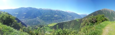
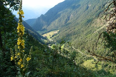
This stage not only crosses several vegetation belts but also changes in terms of landscape from the steppe vegetation that prevails at the Sonnenberg to the vegetation of the central alpine area with its dry, cold climate. Barren pastures stretch out amid the sparse larch woodland that continues high up on the steep mountain slopes to the south of the central alpine ridge, and above them the glaciers of the high summits shine into the valley. Numerous hiking trails lead from the vineyard-covered slopes of the Sonnenberg up onto the eternal ice of the glacier region. The Schnalstal valley has from time immemorial been the access point out of the Etschtal valley to the Ötztalferner glaciers and thus the crossing to Vent or Obergurgl in the northern Tyrolean Ötztal valley. The valley is 24km in length and winds its way from the Weißkugelkamm ridge between the Saldur and Schnals ridges from the north west to the south east. The highest and steepest farmsteads in South Tyrol are located in the Schnalstal valley. In the past, the valley economy was above all centred on livestock farming and forestry, and only in recent centuries could the slow depopulation be stemmed by the creation of tourism-generated jobs. The Schnalstal valley is predominantly a woodland valley, with mountain meadows, grassland and pastures – depending on the altitude – only located around the various settlements. The settlements in the valley are situated on high terraces set one over the other. The traditional processions into the hamlets of Karthaus, Unser Fraua nd Katharinaberg are of cultural interest. They take place (with the participation of orchestras in traditional costume) on the Corpus Christi and Sacred Heart of Jesus Sunday holidays and on the respective church consecration festival of each village.
(Stefan Illmer, Karin Leichter, AVS)
Other long-distance trails and alternative routes
Meran high-altitude trail, Archaeological hiking trail.
Useful topographic maps
-
Nr. 52 Vinschgau ~ Kompass (1:50.000)
-
Nr. 04 Schnalstal ~ Tabacco (1:25.000)
-
WKS 12 ~ Freytag & Berndt (1:50.000)
Useful guidebooks
-
Lexikon 52 Vinschgau ~ Kompass (ISBN 3-85491-058-4)
-
Wanderführer Rund um Meran ~ Rother (ISBN 3-7633-4267-2)
-
Wanderführer Vinschgau
~ Rother (ISBN 3-7633-4205-2)
-
Via Alpina Gelber Weg, Evamaria Wecker ~ Bruckmann (ISBN 978-3-7654-4858-7)
Websites relative to natural and cultural heritage
Last update : 2009-12-03

 |
3h15 |
11 km
|
2339 m
|
2397 m
|
3h15 |
11 km
|
2339 m
|
2397 m


Favourites, criticisms ? Make your personal comments on this stage. For more general notes please use the comments section of the page Over to the Via Alpinists.