Hiking (mountain trail, in places narrow and exposed)
Alpine route (equipped or very exposed section, snow field, blocks)
B29
Hochganghaus / Rifugio del Valico » Jausenstation Patleid
|
3h50 |
16 km
|
2037 m
|
2490 m
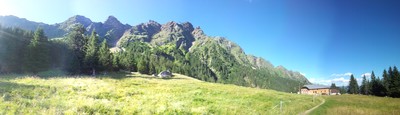
The stage starts at Hochgang lodge in the protected zone of Texel Nature Park. This stretch of the route leads to the AVS Jugendweg trail (corresponds to part of the Meraner Höhenweg) past meadowland into the Zieltal valley to the Nassereit Hut (1,523m). Other stopoffs on the trail to the Patleid snack-bar (destination, 1,368m) is offered by the Giggelberg, Hochforch, Grub and Galmein inns.
This stage starts at the Hochgang refuge in the middle of a protected area, the Texel group nature park. The trail leads on the AVS youth trail (corresponds to a section of the Merano ridge trail) past meadowland on a gentle descent into the Zieltal valley and the Nassereit Hut (1,523m, catering and accommodation facilities). Other stop-off possibilities on the way to the Patleid snack bar (stage destination, 1,368m) are offered by the Giggelberg, Hochforch, Grub and Galmein inns; most of them are, according to tradition, connected by little cable cars with the villages in the valley. Stage B29 does not pose any orientation difficulties and there is only a slight change in altitude (exceptions: secured stream crossings). It heads over meadowland or through mixed woodland along the much trodden and secure Merano ridge trail. Hikers may be surprised that on many occasions, the trail leads straight through farmsteads! Difficulties may be experienced when crossing the watercourses if there has been recent heavy rainfall: the trail is then mostly no longer so easy to distinguish; in addition to this, there can in certain conditions also be a risk of rock falls. According to the stage divisions, Via Alpina hikers thus make their way along the entire south side of the Texel group in a two-day hike. (Stefan Illmer, Karin Leichter, AVS)
Natural and cultural heritage
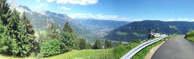
With a surface area of 33,430ha, the Texel group nature park, approved in 1976, is the largest nature park in South Tyrol. The nature park comprises the Texel massif, a far-reaching high mountain region between the Schnalstal valley in the west and the Passeiertal valley in the east, and also parts of the Ötztal Alps with the Schnals and Gurgler ravines. The nature park area is one of the most interesting landscapes in South Tyrol, especially from a morphological viewpoint, as it comprises all of the different alpine forms, from the glacier-covered high mountains to the meadowland and from lynchets down to the valley floors. During the Ice Ages, today’s nature park zone was carpeted in mighty glaciers. These reshaped headwater hollows into cirques and the profile of the valleys was rounded out. The erosion caused by side glaciers was not so deep, thus leading to the formation of sloping valleys. In the area of the valley floors, sharp-edged and humpbacked landscapes formed. There are moraines in virtually all of the valleys and valley heads in the reserve. The landscape was sculpted by water above all in the post-glacial age. The joint impact of glacial ice and water created the many mountain lakes that today represent special points of attraction in the landscape. High above Merano lie the Spronser lakes, the largest high-alpine lake group in South Tyrol (approx. 2,100m – 2,600m). Alongside numerous raging torrential streams, the waterfalls are particularly evident (e.g. Partschinser waterfall). The glaciation process, which occurs from the border ridge to the areas of the Texel, Trübwand, Lodner and Gfallwand mountains, is crucial to the water regime. Particularly in the last century, the glaciers receded visibly, and several have even disappeared entirely. The Mediterranean climate, the low rainfall levels and a slope gradient propitious to sun exposure are components that make this area an unequalled habitat for many plants and animals. The Texel group nature park comprises (especially in the south west) part of the Vinschgau Sonnenberg (the warm, dry southern slopes at Partschins and Naturns). Like all talus settlements, the district of Partschins, through which most of this stage passes, is based on old arable soil. The first inhabitants of this area arrived about 5,000 years ago, although the chequered history refers to several tribes. Due to the nature of the landscape, the land was settled from the top down. In the area surrounding the trail, mysterious megalithic stones and pagan worship places from prehistoric times can be admired – silent witnesses to the original settlers who once lived here. The meaning of the various pagan symbols remains a mystery. (Stefan Illmer, Karin Leichter, AVS)
Other long-distance trails and alternative routes
The Meraner Höhenweg trail circumvents the Texel Nature Park, near which trail no. 24 covers around 100km in approx. 6-7 daily stages. Owing to the many possible climbs and descents, you can start the hike from a point of your choice.
Useful topographic maps
Nr. 53 Meran und Umgebung ~ Kompass (1:50.000)
Nr. 011 Meran und Umgebung ~ Tabacco (1:25.000)
WKS 1 und WKS 12 ~ Freytag & Berndt (1:50.000)
Useful guidebooks
Lexikon 53 Meran und Umgebung ~ Kompass (ISBN 3-85491-059-2)
Wanderführer Rund um Meran ~ Rother (ISBN 3-7633-4267-2)
Favourites, criticisms ? Make your personal comments on this stage. For more general notes please use the comments section of the page Over to the Via Alpinists.
Julien - 2020-07-31
Étape en balcon, longue et monotone. Le terrain granitique est exigeant.
Effectivement les temps donnés ne sont pas bons.
Je recommande de tenter une variante plus haut.
Monaco - Trieste
Possible variante here to stay up
Possible variante from Vernago : trail #18 to croda rotta 2815m
Or from Unser Frau : trail #27 to Vorderkaser, Johannesescharte pass 2854m, lodnerhutte and then reach Hochgang Haus by trail #7 (franz huber steig)
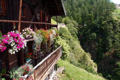
Hochganghaus is serving great food. B&B at 25euros, allowed me to pitch the tent in the vincinity for free. 2euros for a 6mins hot shower.Great view on the Dolomites Catinaccio/rozengarten from there
Mountain Girl - 2012-10-16
"Pirchhof" is another lodging option, just before Gasthaus Grub. It's super clean & friendly, and features homemade pies and milk fresh from cows in a barn nearby. A charming spot!
Philippe - 2010-08-05
Attention, horaire assez optimiste. Je recommande de rajouter 2 bonnes heures.
Automatic translation
[Google]
Attention, rather optimistic times. I recommend adding a good 2 hours.

 |
3h50 |
16 km
|
2037 m
|
2490 m
|
3h50 |
16 km
|
2037 m
|
2490 m


Favourites, criticisms ? Make your personal comments on this stage. For more general notes please use the comments section of the page Over to the Via Alpinists.