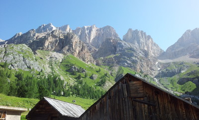
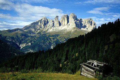
From the Contrin hut, a broad trail (648) climbs to the San Nicolò pass and hut, along the edge of a rock face that rises all the way to the peak of the Ombert pass. Then head north west (trail 613) along the ridge that divides the San Nicolò valley from Val di Contrin, passing the peak of Mt Varos along the way, with its ruins of fortifications that date from World War I. A little further on there is a fork. Take the trail on the right, along the eastern face of Mount Sas da Rocia, and up to the narrow pass between the peak and the Dantone tower. Guide ropes assist the walker across two short, rocky stretches and the trail heads straight west towards the Forcia Neigra pass at the foot of Mount Colac. From here the trail heads down rapidly into the Ciampac valley and, passing right under a number of cliff faces, (under no circumstances take a break here in case of rain or storms), leads to the ski resort, just below a ski lift. Follow a rough path through the grass towards the cable car to the track that leads towards the Tobià del Giagher hut. Head down along the track for a short stretch until, near some huts (and the beginning of trail 645) it turns left. Climb the steep grassy slope to Pian de Siele. On the Val de Grepa side the trail is steep initially but then becomes much gentler. It passes an old, renovated barn, crosses the stream and, after a few metres, continues along the flat bottom of the valley. It passes through a gate and quickly towards the Duin ridge and hut, where the road begins. The old paving stones can still be seen today. It winds down, the bends narrow and steep, to the bottom of the valley and the Avisio stream. Once over the bridge over the Avisio, a narrow road leads to the hamlet of Fontanazzo. Alternative: just before the Croda Nera cliffs, follow the signs for trail 613b to skirt round the southern face of Mount Sasso di Rocca along the Lino Pederiva trail, kitted out with guide ropes, until it rejoins the 613, just south of the Sella Brunech pass. At the pass, the trail heads down to the Ciampac plain along trail 644. From Fontanazzo take trail 645 up towards the Crepa valley. The trail emerges from the woods into the high valley plateau, where there are a number of pastures and barns. The ascent is then along the winding trail to Pian de Siele and then down towards the Ciampac valley. At the Tobià del Giagher pass, the trail then climbs the opposite slope to the Forcia Neigra pass. It then skirts around the eastern face of Mt. Croda Nera to reach Sasso Bianco and then, along the grassy ridge, to the San Nicolò pass. The route is then down into Val Contrin (trail 608) and the Contrin hut. (Provincia Autonoma di Trento)
Natural and cultural heritage
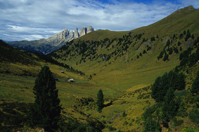
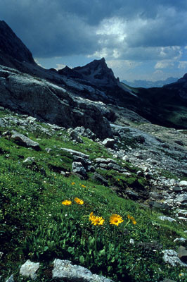
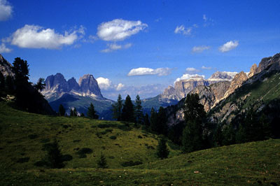
The view right across the two valleys of Contrin and Grepa, located side by side, is spectacular thanks both to the landscape and to the vegetation. From woodland the trail moves into pastures and back into woodland again, through the unusual colour of the magma rock and surrounded by the giant peaks of the Dolomites. It is interesting to note the different uses to which the valleys were put and the results of this today: Contrin is the haunt of day-trippers; Ciampac is full of ski lifts and hotels; Val di Crepa on the other hand is still used for livestock farming. (Provincia Autonoma di Trento)
Useful topographic maps
06 ~ Tabacco (1:25.000)
686 ~ Kompass (1:25.000)
8 ~ Lagiralpina (1:25.000)
Useful guidebooks
"Val di Fassa", Fabrizio Torchio e Enzo Gardumi (1996) ~ Kompass-Fleischmann (ISBN )
Favourites, criticisms ? Make your personal comments on this stage. For more general notes please use the comments section of the page Over to the Via Alpinists.
Jean-Louis GIRAUD - 2014-03-19
Fontanazzo est une étape touristique et le prix des hebergements est à un niveau relativement élévé.
Bon accueil à l'Hotel Ciamol à proximité des sentiers .
www.hotelciamol.com
Tel : +39 0462 767117
Petit supermarché dans le bourg de Campitello di Fassa
Automatic translation
[Google]
Fontanazzo is a tourist stop and the price of accommodations is at a somewhat elevated level. Welcome the Hotel Ciamol nearby trails. www.hotelciamol.com Tel: +39 0462 767117 Small supermarket in the village of Campitello di Fassa
Monaco - Trieste
in the vincinity of Rifugio Tobià del Giagher there is an opened clean all wood hut with electricity in the skiing area.
It is possible to sleep and eat at Passo S. Nicolò (better option than very touristic rifugio Contrin)
From Cointrin alm there is an alpinist way to reach lago di Fedaia on the other side without going down to Penia
Via Alpina International Secretariat - 2011-10-31
@Uwe & Schritt für Schritt: Die Höhenunterschiede für jeder Etappe werden anhand des Tracks berechnet, was für die meisten Etappen optimale Informationen liefert. Das führt aber hier, wo noch keine präzise GPS-Daten vorhanden sind und die Trasse noch sehr grob ist, zur Berücksichtigen falsch positionierter Punkte und zusätzlichem Auf- und Ab, daher die überschätzten Werte. Nathalie Morelle, Internationale Koordinatorin Via Alpina
Automatic translation
[Google]
@ Uwe & Step by Step: The height differences for each stage are calculated using the tracks, which for most stages provide optimal information. But this leads here, where no precise GPS data are available and the route is still very rough, to consider misplaced points and additional up-and, therefore, the above estimated values. Nathalie Morelle, International Coordinator Via Alpina
Schritt für Schritt - 2011-09-14
Die Höhenangaben stimmen wirklich nicht!
Das Rif.San Nicolo ist eine wunderbare Alternative zu, Rif.Contrin; am Abend sehr still, fantastische Aussicht und lange Sonnenscheindauer!
Automatic translation
[Google]
The elevation data are wrong really!
The Rif.San Nicolo is a wonderful alternative to Rif.Contrin; evening very quiet, fantastic views and long hours of sunshine!
Uwe - 2011-08-25
Bin in der letzten Woche u.a. die Etappe B23 in Gegenrichtung gelaufen. Die angegebenen Höhenmeter (2275 hoch u. 1655 runter) hatten mich erschreckt. Habe deswegen mit der Karte abgeschätzt und kam auf max. 1600 m Aufstieg und 850 m Abstieg. Der Führer von Evamaria Wecker gibt für die Etappe in Originalrichtung 740 hoch und 1360 runter an. Anhand eines Logs des Höhenmessers habe ich meine Schätzung überprüft. Von Fontanazzo bis zum Rif. Tobià del Giagher habe ich 942 m rauf und 194 m runter zurückgelegt. Geschätzt hatte ich bis dahin 1100 m hoch und 300 m runter. Meine Schätzung war also schon deutlich zu hoch. Woher kommen die deutlich höheren Angaben in der Etappenbeschreibung? Ist da ein Fehler oder rechne ich anders?
Automatic translation
[Google]
I inter alia in the last week passed the stage of B23 in the opposite direction. The specified altitude (2275 up, down and 1655) had scared me. Have therefore estimated using the card to hit max. 1600 m ascent and 850 m descent. The leader of Evamaria alarm is for the stage in the original direction 740 at high and 1360 down. Based on a log of the altimeter, I checked my estimate. Of Fontanazzo to Rif. Tobià del Giagher I up 942 m and 194 m back down down. I had previously estimated 1100 m high and 300 m down. My estimate was thus already far too high. Where do the significantly higher numbers in the stage description? There's a bug or I expect otherwise?
Bertrand - 2010-06-17
J'aimerais commencer la Via alpina jaune à Resuitta.J'ai déjà fait la traversée de la Slovénie.Pourriez vous me dire si je peux laisser mon véhicule à Fontanazzo pendant 15 jours et comment me rendre de Fontanazzo à Resuitta.(car etc......)Merci d'avance
Automatic translation
[Google]
I would like to start the Via Alpina yellow Resuitta.J have already made the crossing of the Slovénie.Pourriez you tell me if I can leave my vehicle for 15 days and Fontanazzo How do I get to Fontanazzo Resuitta. (Because so. .....) Thanks in advance
Via Alpina International Secretariat - 2009-11-24
@Greg - Indeed we found a technical problem in the database for this and a few other stages. It should all be correct now. Sorry and thanks for your interest! - Nathalie Morelle, Via Alpina International Secretariat
Hi,
I can't quite work out the times and distances for this stage in the Fontanazzo-rifugio Contrin direction. Is 3h20 the total time to climb from Fontanazzo to Pian de Siele and then go back down to the Tobia refuge?
Your experience of this stage is much appreciated
Regards,
Greg

 |
6h10 |
13.6 km
|
1655 m
|
2275 m
|
6h10 |
13.6 km
|
1655 m
|
2275 m


Favourites, criticisms ? Make your personal comments on this stage. For more general notes please use the comments section of the page Over to the Via Alpinists.