Create your own guidebook
Download track
Quality : rough
GPX KML CSV
Location
Italy
Veneto
Belluno
Domegge di Cadore - Calalzo di Cadore
Val Talagona - Val d'Oten - Gruppo Antelao

Key to symbols   
Stage point (start or end of stage)
Intermediate accommodation possibility
Summit
Pass
Town, village
Other locality

Catering
Doctor
Chemist
Bakery / grocery
Hardware / sports shop
Post
Bank / cash dispenser
Train
Coach
Taxi
Open automobile access

A Tarred or paved road
B Dirt track
C Mule trail
D Mountain trail
E Equipped trail (cables, ladders)
F No trail

Stroll / tourism (broad, non-exposed trail)
Hiking (mountain trail, in places narrow and exposed)
Alpine route (equipped or very exposed section, snow field, blocks)
B18 Rifugio Padova » Rifugio P. Galassi
  |   7h00   |   21.3 km   |   1892 m   |   1162 m

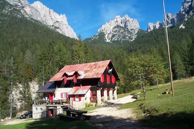
The Padova hut can be reached by car from the bottom of the valley. From the hut, the trail descends to the Piave river, which it crosses and then climbs again, up the Oten valley through the heart of the Cadore. The stage ends at the Galassi hut, under the imposing peaks of Mount Antelao.

Point Segment
Name Services Information Marking
Rifugio Padova
1287 m
| ABD  6.4 km / 2h00
Vallesella-Domegge
711 m
| A  0.9 km / 0h20
Grea
910 m
| D  3.2 km / 0h20
Rizzios
847 m
| A  3.4 km / 1h00
Praciadelan (Val d'Oten)
1044 m
| B  2.7 km / 1h30
Capanna degli Alpini
1395 m
| D  4.7 km / 1h50
Rifugio P. Galassi
2018 m
Detailed route description
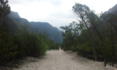
Other long-distance trails and alternative routes
Alta via trails nos. 4 & 5. The trail follows the Antelao glacier. Mountaineers can climb Mount Antelao (3264m).
Useful topographic maps
  • foglio 016 ~ Tabacco (1:25.000)
Useful guidebooks
  • Guida Monti d'Italia - Dolomiti orient. vol I parte 1^ ~ CAI-TCI (ISBN )
  • Dolomiti del Cadore, C. Berti e R. Tabacchi ~ Edizioni Panorama (ISBN )
  • Antelao-Sorapiss-Marmarole, L. Visentini ~ Athesia (ISBN )
  • Via Alpina Gelber Weg, Evamaria Wecker ~ Bruckmann (ISBN 978-3-7654-4858-7)
Comments

Favourites, criticisms ? Make your personal comments on this stage. For more general notes please use the comments section of the page Over to the Via Alpinists.


max. 1000 characters
  • Chilperic - 2023-08-09
    Le pont sur la Piave est de nouveau praticable (aux piétons et cyclistes, et théoriquement interdit de nuit), depuis le 17 juillet 2023.
  • Bruno - 2023-07-14
    The bridge between Calalzo di cadore and the other side of the river is now closed (so does the camping). I recommend to go through the bridge in Dommege di Cadore(3km longer).
  • Po & Ju - 2018-11-06
    La descente a Domegge vallesella est sur route, trop longue et peu intéressante. Nous avons fait du stop. La remonté dans le val d’oten est longue mais joli. C'est très rocailleux. La cascade de la Pille vaut vraiment le petit détour et son chemin d'accès aussi. Montée plus raide jusqu'au galassi. Le refuge est tenu par des bénévoles très sympa. Départ pour la course d'alpinisme du mythique et majestueux Mont Antelao dont la légende laisse pantois…
    Automatic translation [Google]
    The descent to Domegge vallesella is on the road, too long and uninteresting. We hitchhiked. The recovery in the valley of oten is long but pretty. It's very rocky. The cascade de la Pille is really worth the detour and its path too. Steep climb to the galassi. The shelter is run by very nice volunteers. Departure for the mountaineering race of the mythical and majestic Mount Antelao whose legend leaves you speechless ...
  • Jean-Louis GIRAUD - 2014-03-08
    Quelques magasins...sports et épicerie / boulangerie à Calalzo di Cadore. Accueil trés cordial au Rifugio P.Galassi, géré par une équipe de bénévoles du C.A.I. de Mestre. Aprés un interminable faux- plat dans le Val d'Olten
    la montée, puis l'arrivée au refuge, sous les pentes du Mont Antelao est longue mais magnifique. Beau coucher de soleil à la brèche Piccola...
    Automatic translation [Google]
    Some shops ... sports and grocery / bakery Calalzo di Cadore. Very cordial welcome to Rifugio P.Galassi managed by a team of volunteers CAI Mestre. After a false-ending flat in the Val d'Olten climb, then came to the shelter on the slopes of Mount Antelao is long but beautiful. Beautiful sunset in the breach Piccola ...
  • Thierry M - 2014-01-26
    The way down from rif Galassi is very long and boring, possible variante if good weather (check my blog day 60 for map and details)

    1400m Cascata de pille (5mins off the via alpina) just before Rifugio Capanna Degli Alpini
    1044m Praciadelan. There is an all year round opened restaurant here

    900m by the road, roof with no walls, BBQ place, water stream passing by

    After crossing bridge at Lago di centro cadore, 2h of boring road walk to reach rif Padova, on the way there is another rifugio called Cercena 1075m (half way in between the bridge and rif Padova)

    rif Padova offers warm bed for 12euros (3euros for a hot shower), familly runned place = good place to stay
  • M.Keller - 2013-04-06
    On peut dormir à Capanna degli Alpini. Accueil familial sympa. Refuge calme.
    Automatic translation [Google]
    We can sleep Capanna degli Alpini. Nice family home. Quiet refuge.
  • Via Alpina International Secretariat - 2011-08-15
    @ C. Tramontini: abbiamo aggiornato l'informazione, grazie per la notizia! Nathalie Morelle, coordinatrice internazionale Via Alpina
    Automatic translation [Google]
    @ C. Tramontini: we have updated the information, thank you for the news! Nathalie Morelle, coordinator of international Via Alpina
  • Claudio Tramontini - 2011-07-28
    All'indirizzo http://www.via-alpina.org/it/point/456 c'è l'indicazione del referente errata: dal 2010 il responsabile è il sottoscritto: Claudio Tramontini.
    Mentre l'indirizzo è corretto il CAP deve essere modificato in 30171.
    Grazie
    Automatic translation [Google]
    At http://www.via-alpina.org/it/point/456 is an indication of the referent wrong: from 2010 lies with the undersigned: Claudio Tramontini. The address is correct, the CAP should be changed to 30171. Thanks
Last update : 2011-08-15