Create your own guidebook
Download track
Quality : rough
GPX KML CSV
Location
Italy
FRIULI VENEZIA GIULIA
UDINE
LUSEVERA
VALLI DEL TORRE

Key to symbols   
Stage point (start or end of stage)
Intermediate accommodation possibility
Summit
Pass
Town, village
Other locality

Catering
Doctor
Chemist
Bakery / grocery
Hardware / sports shop
Post
Bank / cash dispenser
Train
Coach
Taxi
Open automobile access

A Tarred or paved road
B Dirt track
C Mule trail
D Mountain trail
E Equipped trail (cables, ladders)
F No trail

Stroll / tourism (broad, non-exposed trail)
Hiking (mountain trail, in places narrow and exposed)
Alpine route (equipped or very exposed section, snow field, blocks)
B9 Montemaggiore » Passo di Tanamea
  |   4h30   |   15 km   |   471 m   |   470 m

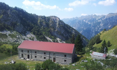
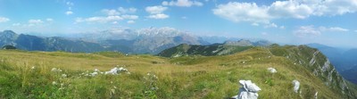
From the hamlet of Montemaggiore a mule track climbs to the top of Montemaggiore, providing good views along the way. After a steep grassy ridge, the trail winds its way down again through fields and pine woods to the Tanamea pass below. The accommodation is at Pian dei Ciclamini (Lusevera), 4km down the road to the west.

Point Segment
Name Services Information Marking
Montemaggiore
795 m
| E  6 km / 2h00
Punta di Montemaggiore
1613 m
| E  9 km / 2h30
Passo di Tanamea
857 m
Detailed route description
Natural and cultural heritage
Useful topographic maps
  • 026 ~ TABACCO (1:25000)
  • 026 ~ TABACCO (1:25000)
  • L'alta via delle Valli del Natisone ~ Club Alpino Italiano - Sezione di Cividale del Friuli (1:50000)
Useful guidebooks
Comments

Favourites, criticisms ? Make your personal comments on this stage. For more general notes please use the comments section of the page Over to the Via Alpinists.


max. 1000 characters
  • Stasa - 2019-12-15
    On the way B9 welcome to visit beautiful village Robidisce, just on the way. Sleeping facilities there!
  • DAVIDBOOTH - 2015-09-11
    THE ALBERGO CICLAMINI AT PASSO TANAMEA HAS BEEN CL:OSED FOR MORE THAN ONE YEAR
  • Jean-Louis GIRAUD - 2014-02-22
    Bel itinéraire de montée pour atteindre La Punta di Montemaggiore mais attention au balisage à la sortie du village. En effet, il faut assez rapidement quitter le chemin muletier pour emprunter sur la gauche un petit sentier qui monte dans les bois .
    Sur l'itinéraire de descente vers le Passo di Tanamea, j'ai noté la présence du refuge A.N.A. di MONTEAPERTA ouvert et entretenu par " L'Association Nazionale Alpini sezione di Udine ". A part quelques journées dans l'été, il n'est pas gardé mais le vaste batiment, correctement restauré,offre un confort certain dans une grande solitude !
    L'hotel du col est fermé mais il est possible de rejoindre l'auberge situé en bordure de route, quelques kilomètres a l'ouest du col, au lieu dit " Pian dei Ciclamini "
    Automatic translation [Google]
    Bel ascent route to reach La Punta di Montemaggiore but beware markup outside the village. Indeed, we must fairly quickly leave the mule track to borrow on the left a small trail that goes through the woods. On the route down to the Passo di Tanamea, I noted the presence of ANA refuge di Monteaperta opened and maintained by "The Nazionale Alpini Association sezione di Udine". Apart from a few days in the summer, it is not kept but the vast building, properly restored, offers some comfort in solitude! The hotel of the cervix is ​​closed but it is possible to reach the hostel located roadside, a few miles west of the pass, at a place called "Pian dei Ciclamini"
  • Thierry M - 2014-01-27
    Monaco - Trieste
    Rifugio Aperta (non CAI but kept by one friendly fellow summer season, ex military barracks) which is 2h from the Passo di tanamea road is available and open all year round (beds, gas, food, etc..)
    less than 30minutes to reach high point Punta di Montemaggiore.
    From that high point I will recommend to stay up and move towards Slovenia radther than going low to Montemaggiore and staying in the ugly & dense forest where you do not see anything (drived me crazy spending hours in that mess just to stay in ITALIA..FT...do not do the same mistake...cross the border, move on to beautiful and exciting Slovenia..do the Matajur and finish to Trieste in Slovenia on the red trail..
    NB : yes there are ticks and nasty ones, not only in the high grass..lots in the woods
  • Carol - 2013-11-01
    The meadows above Montemaggiore and along the ridge were infested with ticks in Aug. of 2013. Parts of trail 742 along the ridgetop (not 744 as indicated in the VA directions) were overgrown with chest-high grass, especially just before trail 711a, where we descended to the (closed) Rif. Monteaperto (probably the WWI hospital mentioned in the previous posting) rather than continue to 711.
  • EllieSektionBritannia - 2011-10-03
    Views from the ridge at Punta di Montemaggiore are magnificent, possibly to the Dolomites on a clear day. There is a restored WW1 field hospital just below the ridge on the northern side, which looked closed when we were there. Its name varies according to which edition of map you have.
  • EllieSektionBritannia - 2011-10-03
    At Montemaggiore we stayed at Casa Svetlana, which is the accommodation above the Trattoria Montecarlo, just downhill from the church. Try http://engine.xnotta.it/contatto.aspx which lists several small B&Bs in the area. The location of a B&B can be hard to find, as the address for all of them is based on the post town, not the village or hamlet. Our host spoke German and his wife Russian.
  • Joan Miller - 2010-07-26
    Pian dei Ciclamini and the accommodation is 4km along the road to the west of Tanamea Pass.
Last update : 2013-02-25