Create your own guidebook
Download track
Quality : rough
GPX KML CSV
Location
Italy
FRIULI VENEZIA GIULIA
UDINE
DRENCHIA
VALLI DELLO JUDRIO E DEL NATISONE / PREALPI GIULIE

Key to symbols   
Stage point (start or end of stage)
Intermediate accommodation possibility
Summit
Pass
Town, village
Other locality

Catering
Doctor
Chemist
Bakery / grocery
Hardware / sports shop
Post
Bank / cash dispenser
Train
Coach
Taxi
Open automobile access

A Tarred or paved road
B Dirt track
C Mule trail
D Mountain trail
E Equipped trail (cables, ladders)
F No trail

Stroll / tourism (broad, non-exposed trail)
Hiking (mountain trail, in places narrow and exposed)
Alpine route (equipped or very exposed section, snow field, blocks)
B6 Castelmonte / Stara Gora » Rif. Casoni Solarie
  |   5h30   |   19.5 km   |   461 m   |   94 m

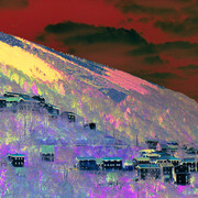
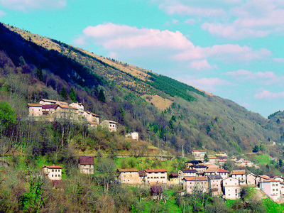
At Castelmonte, the Alta Via trail of the Natisone valleys begins. It follows the length of the right bank of the Judrio Torrent; there are a number of typical churches and villages along the way. Past the hilltop fortifications of Cum and the church of S. Volfgango, the stage ends at the Casoni Solarie Hut.

Point Segment
Name Services Information Marking
Castelmonte / Stara Gora
618 m
|   13 km / 3h30
Clabuzzaro
802 m
|   6.5 km / 2h00
Rif. Casoni Solarie
956 m
Detailed route description
Natural and cultural heritage
Useful topographic maps
  • 041 ~ TABACCO (1:25000)
  • L'alta via delle Valli del Natisone ~ Club Alpino Italiano - Sezione di Cividale del Friuli (1:50000)
Useful guidebooks
Comments

Favourites, criticisms ? Make your personal comments on this stage. For more general notes please use the comments section of the page Over to the Via Alpinists.


max. 1000 characters
  • Vaeltava tohtori - 2018-07-13
    Caseria Solaria has new owners, very hospitable and friendly. Good food!
  • Michael Andries - 2014-08-06
    I ran from Solarji to Castelmonte and back. Was a super nice training. Very quiet surroundings and lots of runable sections. Was an easyer day then runing in TNP. The Radler in Solarje was very cold! Kolovrat is also a must see!
  • Jean-Louis GIRAUD - 2014-02-19
    Longue et belle étape sur les flancs et les crètes de collines boisées chargées de souvenirs des combats de la première guerre mondiale. Sentier trés bien tracé qui évite parfaitement les petites routes et donc le goudron. Avec quelques dénivellées, la derniere partie de l'étape conduit au Mont Cum puis au Rifugio Solarie situé à proximité d'un col à 30 mn au dessus du village de Clabuzzaro. Accueil trés sympathique.Emouvante collection de photos anciennes de scènes de guerre sur cette zone frontière
    Possibilité d'hébergement intermédiaire au pied du Mont Cum :
    B and B "Alla Rosa dei Venti"
    Via Tribil Superiore, 50
    STREGNA
    Cellular +39334/1275353
    Email :allarosadeiventi@libero.it

    Rifugio SOLARIE
    33040 DRENCHIA
    Cell:+39334/1203924
    +39339/1676144
    Ouvert tous les jours durant les mois d'été. Bonne cuisine traditionnelle avec Gubana au dessert !
    Automatic translation [Google]
    Long and beautiful stage on the flanks and ridges of wooded hills full of memories of the battles of the First World War. Very well marked path that avoids the roads perfectly and therefore tar. With some dénivellées, the last part of the section leads to Mount Cum then to Rifugio Solarie near a neck 30 minutes above the village of Clabuzzaro. Home very sympathique.Emouvante collection of old war scenes photos on this border area Possibility through accommodation at the foot of Mount Cum: B and B "Alla Rosa dei Venti" Via Tribil Superiore, 50 Stregna Cellular +39334/1275353 Email: allarosadeiventi@libero.it Rifugio Solarie Drenchia 33040 Cell: +39334/1203924 +39339/1676144 Open daily during the summer months. Good food with traditional gubana dessert!
  • Elsa - 2012-07-15
    War am 11.6.12 unterwegs. Regen fast den ganzen Tag. Bis zur Kapelle San Nicolo auf bezeichnetem Weg gelaufen, der rutschig war und teilweise mit hohem Gras bewachsen. Ab dort bin ich bis San Wolfgango immer über die Strasse gelaufen (wenig Autos) Das Rifugio Solarie habe ich geschlossen vorgefunden. Es öffnet erst im Juni und nicht wie im Führer geschrieben im April. Habe wohl oder übel im Biwak Zanussi (nächste Etappe) übernachten müssen
    Automatic translation [Google]
    Was traveling on 11/06/12. Rain most of the day. Went to the chapel of San Nicolo on signified path was slippery and partly overgrown with tall grass. From there I went to San Wolfgango always on the road (few cars) Rifugio Solarie I found closed. It only opens in June and not written in the guide in April. Have better or worse, have to stay in the bivouac Zanussi (next stage)
  • EllieSektionBritannia - 2011-10-03
    A very long stage, with long stretches on roads, but thankfully there was hardly any traffic. Through woods and over meadows. We were the only guests at the hut, and the evening meal of wild boar was first rate and was greatly appreciated after the long journey.
  • Pascal - 2009-09-03
    La montée sur la crête n'est absolument pas linéaire mais présente de gros dénivelé avec notamment une montée très abrupte pour se rendre au sommet du Mt Cum. Il faut donc compter facilement 7 à 8 heures de marche
    Automatic translation [Google]
    Climbing the peak is definitely not linear but has large elevation including a steep ascent to reach the summit of Mt Cum. It is therefore easily count 7-8 hours walking
Last update : 2009-12-03