Hiking (mountain trail, in places narrow and exposed)
Alpine route (equipped or very exposed section, snow field, blocks)
B3
Villa Opicina (Sella di Opicina) / Opčine » Sistiana / Sesljan
|
6h40 |
22.5 km
|
8 m
|
204 m
From the Obelisk the Cobolli trail goes past the old town of Prosecco and meets trail no. 9, which leads down to Miramare. On the way to Santa Croce del Carso is the Liburnia tower. The "Sentiero della salvia" (Sage trail) leads to the Tiziana Weiss viewing point. The route then follows the SS. 14 Venezia Giulia road to Sistiana.
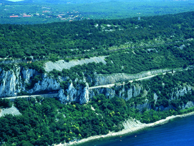
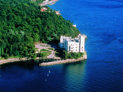
From the Obelisk the route continues downhill and then uphill, gaining in altitude along the Napoleonic road that passes below the Mariano di Monte temple. Grisa: From the terrace there are views across the whole city of Trieste and its Gulf. On clear days the view of the Alps stretches as far as Mount Grappa. The next village is Prosecco (249m). A detour of about 5km leads to the Grotta Gigante (giant cave) (geodesic pendulums that measure the tides). It is the largest cave open to the public in the world, a classic example of the Karst plateau phenomenon in a region that is largely defined by it. From Prosecco, follow trail 6/1 to the village of Santa Croce del Carso (207m). On the coast below the marble castle of Miramare stands out, perched proudly above the blue sea. This castle was the residence of Maximilian of Hapsburg, later Emperor of Mexico. A minor detour takes in the Vedetta Slataper lookout point (trail 7), and the Liburnia Tower. This route however follows the lower “Sentiero della Salvia" (Sage route) to Aurisina (144m), with its Roman quarry of precious marble. The steep trail 23/1 leads up to the Tiziana Weiss Belvedere and down again to the SS14 road below. Trails 6, 7 and 23 wind along the edge of the Karst plain, perched above the Adriatic. This route affords views of the entire Gulf of Trieste, from the bay of Capodistria and the Punta Salvore to Monfalcone, the mouth of the river Isonzo and the Grado and Marano lagunes. To the right are the last foothills of the Alps of the Giulia and Carnia regions and, fading into the distance to the west, the peaks of the Belluno Dolomites, towering above the Venetian, Treviso and Vittorio Veneto plains. The stage ends at Sistiana, in the administrative area of Duino-Aurisina. (Regione Friuli Venezia Giulia)
Natural and cultural heritage
This stage follows the Karst ridge. From Prosecco/Prosek, a detour of about 5km leads to the Grotta Gigante (giant cave) (geodesic pendulums that measure the tides). The quarries are open to the public. Above is the Miramare castle, set in magnificent parkland, overlooking the Miramare marine reserve – a visit is a must. Archduke Maximilian of Austria, brother to Emperor Franz Joseph, commissioned the castle. Designed by architect C. Junker, the sumptuous building was begun in 1856 but finished only in 1870, after the death of the archduke in 1867 in Mexico. It was built out of white Istria stone. After changing hands a number of times it became property of the Italian state in 1955. It was made a museum and opened to the public. In some of the castle rooms the dominant theme is the sea: the bedroom and the study in particular are done out in the style of a ship’s cabin. Many of the pictures depict the history of Miramare and the life of the archduke. The park, for which many expert gardeners’ services were recruited, covers an area of 22 hectares. The soil was brought to the site from Stiria and Carinthia while the different tree species come from all around the world: fir trees from Spain and the Himalayas, Cypresses from America and Lebanese cedars. The park is embellished with Greek and roman statues. The castle is the seat of the Miramare marine reserve. It is managed by the WWF and is also home to a marine laboratory. Aurisina/Nebrezina has been known the world over since ancient times for its Roman quarries. Marble from Aurisina was in fact used in a number of buildings in Vienna, Paris, Budapest, Prague, America and Egypt. (Regione Friuli Venezia Giulia)
Favourites, criticisms ? Make your personal comments on this stage. For more general notes please use the comments section of the page Over to the Via Alpinists.
vaeltava tohtori - 2018-07-06
Started hiking yellow route end of May this year from Opicina. Stayed in Opicina at camping place right at the route. Very nice, and the food was great at the restaurant.
Route from Opicina to Sistiana almost all the route on tarmac road, not nice.
Jean-Louis GIRAUD - 2013-11-20
Itinéraire parfois imprécis et qui se partage avec d'autres sentiers arrivant sur une plage ...Malheureusement, j'avais oublié mes palmes et je suis reparti !
A SISTIANA j'ai dormi dans une auberge, située sur la route principale à proximité du Sentiero RILKE qui conduit à DUINO..
HOTEL alla DOLINA-SISTIANA 54/F DUINO
www.hoteldolina.it
info@hoteldolina.it
Supermarché en bordure de route, 2km plus loin,en direction de DUINO .
Automatic translation
[Google]
Sometimes vague itinerary and which shares with other trails arriving on a beach...Unfortunately, I forgot my palms and I left!
At SISTIANA I slept in a hostel, located on the main road near the Sentiero RILKE, which leads to DUINO..
HOTEL alla DOLINA - SISTIANA 54/F DUINO
www.hoteldolina.it
Info@hoteldolina.it
Supermarket on the edge of road, 2km further on, in the direction of DUINO.
Segretariato internazionale Via Alpina - 2013-02-05
@Zuffi Nicolò: correzione integrata, grazie per la notizia.
Automatic translation
[Google]
@ Nicholas Zuffi: integrated correction, thanks for the news.
Zuffi Nicolò - 2013-02-04
Prego sostituire il testo con il seguente: I sentieri 6 - 7 e 23 si snodano sulla dorsale carsica a picco sul mare Adriatico e offrono la possibilità all’escursionista di spaziare con lo sguardo su tutto il golfo di Trieste, dal golfo di Capodistria a Punta Salvore, sino a Monfalcone, le foci del Fiume Isonzo e le lagune di Grado e Marano. Sulla destra si ammirano invece le ultime propaggini delle Alpi Giulie e delle Carniche per perdersi ad Ovest sui contrafforti delle Dolomiti bellunesi sovrastanti la pianura veneta, del trevisano e di Vittorio Veneto.
Automatic translation
[Google]
Please replace the text with the following: The trails 6-7 and 23 meander on karst ridge overlooking the Adriatic Sea and offer the possibility hiker to gaze out over the Gulf of Trieste, from the Gulf of Koper in Punta Savudrija, up to Monfalcone, the mouth of the River Isonzo and the lagoons of Grado and Marano. On the right you can admire instead the last layers of the Julian Alps and Carnic to get lost in the west in the foothills of the Dolomite overlying the Veneto plain, the trevisano and Vittorio Veneto.
Elsa - 2012-07-15
Bis Prosecco wunderschöner Weg oben entlang der Küste. Anmerkung zum Bruckmann Führer: Wenn man in Santa Maria di Salvia wieder auf die Hauptstrasse gelangt, muss man dieser links folgen. Nach ca. 50 Metern sieht man das nächste Zeichen. In Santa Croce muss man sich links halten (nicht bis zur Autostrasse runter). Empfehlenswert in Sistiana: gleich am Anfang des Ortes: Osteria Tre Noci
Automatic translation
[Google]
Prosecco to beautiful way up along the coast. Note to Bruckmann leader: If Santa Maria di Salvia again gets on the main road, you have to follow these links. After about 50 meters you can see the next character. In Santa Croce one has left (not down to the highway). Recommended Sistiana: right at the beginning of the place: Osteria Tre Noci
EllieSektionBritannia - 2011-10-03
Magnificent views out to sea the whole day, and the paths along the cliff top were very good. Some parts were poorly signed, eg around San Gerolamo and Santa Croce. We went on to Duino, and stayed at the Albergo Garni Aurora on Via Trieste, which was very good. The proprietor spoke excellent English, having lived in the UK, and willingly helped us out by contacting one of the later B&Bs.

 |
6h40 |
22.5 km
|
8 m
|
204 m
|
6h40 |
22.5 km
|
8 m
|
204 m


Favourites, criticisms ? Make your personal comments on this stage. For more general notes please use the comments section of the page Over to the Via Alpinists.