|
|
|
A61
|
Linderhof » Kenzenhütte
|
|
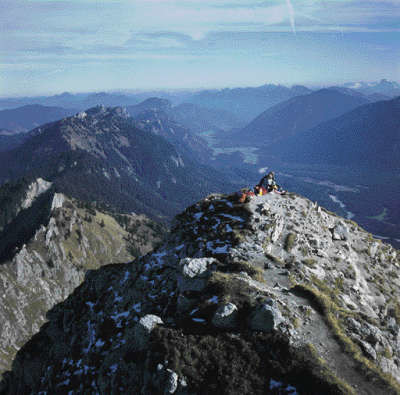
After the last long stage, this one from Linderhof to the Kenzen hut is rather short and invites you to linger, relax, and let your mind roam free. The trail leads steadily upwards along the Sägertalbach stream to the Bäckenalm pasture. From there, it then becomes steep to climb the 1,536m high Bäckenalmsattel pass. On the western side, the trail leads down across alpine meadows to the Kenzen hut.
Detailed route description

From Linderhof take the wide forest road to the south west until almost reaching the main road, then head along the Lindergrieß valley. Next, continue to on another forest road, keeping to the right in a north-westerly direction along the Sägertalbach stream up to the Sägertal service hut. Follow the hiking trail from the service hut. At the turnoff, keep to the right and follow the trail through the wood up to the Bäckenalm meadow. Cross the pastureland and once again head for a short distance through woodland to the west, now on a steep uphill course to the Bäckenalmsattel pass at 1,536m. On the other side of the Bäckenalmsattel pass, the descent to the hunting lodge is just as steep as the earlier uphill climb. At the lodge, you will come across the forest trail coming from the west. Keep to the left now in a southward direction. The walk along the forest path to the Kenzen Hut is an easy one.
From the Kenzen Hut, start off with an easy walk to the Kenzen hunting lodge. Here, keep to the right and follow the track up to the Bäckenalmsattel pass. On the eastern side, the trail again leads steeply down to the Bäckenalm meadow and through the wood down to the Sägertal service hut.
(Christina Schwann, OeAV)
Natural and cultural heritage
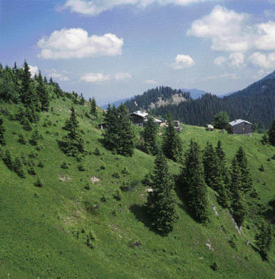
“The Kenzen area is without a doubt the most impressive mountain district in the Bavarian Prealps. A dozen summits form a 270º circle. From soft grass hilltops like the Feigenkopf to the famous and popular climbing peak, the Geiselstein, everything is on offer here” (Dieter Seibert). The Kenzenkopf stands exactly to the north of the Hochplatte plateau and part of its forms a sharp ridge with steep walls on both sides, as the Wetterstein limestone here stands in an exactly perpendicular position. Below the Kenzenkopf and Geiselstein lies the Kenzen Hut. This does not owe its existence to the Alpine Club but has been used since the 16th century as accommodation for woodcutters and hunters. Today, the privately run hut is open for hikers. The abundance of scree in the valleys and the deeply carved ravines are reasons for the impassable nature of this range, which is therefore sparsely populated. Even meadowland is relatively rare. The Ammergebirge mountains, formerly the royal hunting ground, is now the biggest nature reserve in Germany. The part that belongs to Germany is completely under nature protection, even down to the narrow peripheral areas. The numerous forest roads are closed to public traffic. Even mountain railways and lifts are rare here, which is very seldom the case on the northern Alpine periphery.
The fora in the Ammergebirge mountains is diverse, reflecting the geological conditions. Calcicolous and calcifugous plants can be found growing alongside each other, and mention must be made of the numerous types of gentian that bloom here in the mountain summer. In the pastureland area, the alpine buttercup follows the crocus and the soldanella in the course of the year. Columbine, alpine clematis and aconite also occur frequently, while edelweiss only makes a rare appearance. In addition to these there are also numerous other alpine plants that can develop undisturbed here due to the strict protection regulations (any type of intervention in the plant world is prohibited). Chamois, marmots and a large number of red deer live in this nature reserve of the Ammergau Alps covering a total of 27,600 hectares. The populations of mountain cock, black grouse and rock runners should also be mentioned.
(Michael Kleider)
Other long-distance trails and alternative routes
The trail over the peaks to the Kenzen Hut is an alternative route for mountaineers who are sure of foot and free of vertigo, but only in dry weather conditions. At Linderhof, follow the signs for the Brunnkopf houses and head up to the top of the ravine. The path is often very narrow and exposed, although the views are much better. Walking time of approx. 5h. Maximiliansweg, E4
Useful topographic maps
-
WK 352 Ehrwald - Lermoos - Reutte - Tannheimer Tal ~ Freytag & Berndt (1:50.000)
-
Werdenfelser Land ~ Bayerisches Landesvermessungsamt München (1:50.000)
-
Nr. 5. Wettersteingebirge, Zugspitzgebiet ~ Kompass (1:50.000)
Last update : 2011-08-17

 |
3h10 |
9.9 km
|
613 m
|
253 m
|
3h10 |
9.9 km
|
613 m
|
253 m


Favourites, criticisms ? Make your personal comments on this stage. For more general notes please use the comments section of the page Over to the Via Alpinists.