|
|
|
A57
|
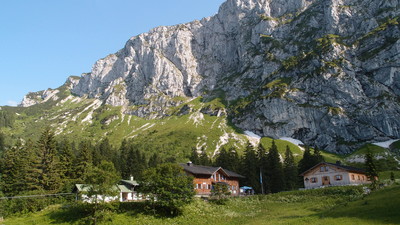
Tutzinger Hütte » Herzogstand
|
|
The stage leads from the Tutzinger hut on a leisurely hike across the many alpine meadows to the Jochbergalm pasture. From here, there is a steep descent to the Kesselberghöhe pass, where you cross the road coming from Walchensee. The well-known Herzogstandhäuser lodges, a popular excursion destination from Walchensee, is the destination point for this stage.
Detailed route description

The trail leads from the Tutzinger Hut on the Benediktenwand "Westweg" trail to the turnoff with the sign for Jachenau. Follow the turnoff to the south and then the west in hairpin bends down to the Glaswandscharte pass. Here, head for a while longer to the south down in the direction of Jochbergalm/Kochl, afterwards taking the turn to the right and heading westward. The trail stretches out along the Glaswand crest mainly on a level course and takes you into the Pessenbacheralm area. A cross and memorial stone stand here in memory of the members of a Penzberg ski club who fell during the war. The trail curves to the west on a lovely and in parts rugged track, finally turning onto a meadow road to the Staffelalm meadow. From the Schrofenalm meadow, the trail leads downhill to the southwest to the Kochleralm meadow. Cross several little streams on a forest road to reach open terrain on an almost level course. Shortly afterwards, the trail turns left to the Jocheralm meadow. It takes you to the Kotalm meadow, where you must keep left along the meadowland towards the west, until the mountain path turns right to the Jocherlam meadow, which lies on the south side of the Jochberg. Continue westward through the pastureland and follow the Jochberg trail through the forest down to the Kesselberg mountain. Here, cross the main road and once on the opposite side start immediately on the "Reitweg" track. This initially leads through woodland on a relatively flat course and later across open terrain over the Schlehdorfer meadow and straight along the south-eastern slope of the Herzogstand peak up to the Herzogstand houses. It is essential to make reservations in advance, as hikers have been turned away before!
From the Herzogstand, follow the trail downhill and cross the main road B11 (Kesselbergstrasse). Then head through the wood to the Jochbergalm meadow.
(Michael Kleider, Christina Schwann, OeAV)
Natural and cultural heritage
In the years 1508-1550, Duke Wilhelm of Bavaria often went hunting on the Farchenberg mountain with his brother, Duke Ludwig. The ducal residence was therefore established on the Farchenberg. King Ludwig II also stayed here frequently, and the current guesthouse used to be a royal residence, which he had built. Two lakes lie at the foot of the ducal residence: The Walchensee lake, 7 kilometres in length, 5 kilometres in width and up to 196 metres deep, making it the biggest and deepest mountain lake in Germany, and the smaller Kochelsee lake with a maximum depth of 66 metres. Between the Walchensee and Kochelsee, there is a good 200 metres’ difference in altitude (Kochelsee 599m, Wachensee 802m). This difference in altitude between the two lakes is used to generate electricity. The Walchensee power station on the banks of the Kochelsee was built under the management of Oskar von Miller, the founder of the German Museum in Munich, between 1918 and 1924. With an output of 124 megawatts, it is still one of the largest high pressure reservoir power stations in Germany. The water streams from the Walchensee down to the Kochelsee through six pipes, each with a diameter of two metres, thus driving eight turbines in the process. Their rotating movement is transferred to generators that produce the electrical current. On the northeastern bank of the Kochelsee lies the Kochel climatic spa resort and not far from here stands the Upper Bavarian Glentleiten open-air museum in Großweil, founded in 1976. With a surface area of 25ha, on which stand around 30 individual rural buildings from the preindustrial era, it is one of the largest complexes of its kind in Bavaria and is the largest open-air museum in the alpine zone. The area can claim yet another superlative with Germany’s oldest mountain road, the Kesselbergstrasse built in 1492 between the two lakes. The first road was laid down for ore mining. In 1893, work had started on the construction of the new Kesselbergstrasse road, which became famous as a mountain race track in the early 20th century. The “blacksmith of Kochel” has gone down in history as a legendary figure. He became a folk hero as the leader of the farmers’ rebellion on Christmas Eve 1705 (“Sendlinger Mordweihnacht”). This rebellion was the struggle for freedom of the Upper Bavarian rural population against the imperial Austrian occupation. A memorial to the Blacksmith of Kochel has been set up in Kochel town centre.
(Michael Kleider)
Other long-distance trails and alternative routes
Ascent of the Jochberg mountain leaving from the Jochbergalm meadow. The Herzogstand can also be reached from Walchensee lake with the Herzogstand cable car. Maximiliansweg, E4
Useful topographic maps
-
Nr. 7 Murnau - Kochel - Staffelsee, Nr.6 Walchensee - Wallgau - Krün ~ Kompass (1:50.000)
-
Bad-Tölz Lenggries u. Umgebung ~ Bayerisches Landesvermessungsamt München (1:50.000)
-
BY 11 Isarwinkel, Benediktenwand ~ Alpenverein (1:25.000)
Useful guidebooks
-
Kompass Wanderbuch, Heinz Fleischmann ~ (ISBN )
-
Wochenendtouren Bayrisches Hochland ~ Bergverlag R. Rother (ISBN )
-
AV- Führer ~ Bergverlag R. Rother (ISBN )
-
Der Maximiliansweg ~ GeoCenter Medienservice Stuttgart (ISBN 3-930187-08-6)
-
Voralpiner Weitwanderweg 04 ~ OeAV-Sektion Weitwanderer (ISBN )
-
Die stillen Pfade der Via Alpina, Evamaria Wecker ~ Bruckmann (ISBN 978-3-7654-4857-7)
Last update : 2011-08-17

 |
6h45 |
19.7 km
|
1327 m
|
1084 m
|
6h45 |
19.7 km
|
1327 m
|
1084 m


Favourites, criticisms ? Make your personal comments on this stage. For more general notes please use the comments section of the page Over to the Via Alpinists.