Hiking (mountain trail, in places narrow and exposed)
Alpine route (equipped or very exposed section, snow field, blocks)
A54
Sutten » Kreuth
|
4h50 |
13.1 km
|
823 m
|
1038 m
This stage is above all characterised by its expanse of woodland. As of the Riedereckalm pasture, however, this thins out, giving a view of the Risserkogel and the Grubeneck. From the Risserkogel, enjoy a fantastic view over to the Tegernsee lake. But you soon dip back onto shady woodland and follow the hiking path into the village of Kreuth.
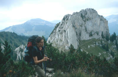
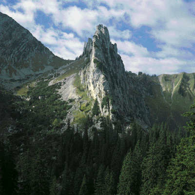
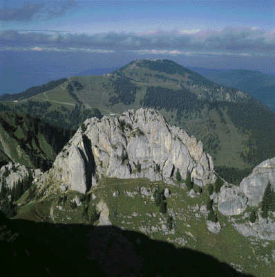
From the Sutten area, and after crossing the very unapparent Rottach stream, follow the signs to the Risserkogel peak. At the start, the trail leads along an asphalt road up through the wood. After approx. 15min, turn left towards the Sieblialm meadow. Above the Riedereckalm, which you will soon reach, the plattenkalk limestone reef of the Blankenstein peak becomes visible with the ridge of the Risserkogel behind it. You will reach a grassy basin on a level with the marshy Riederecksee lake. A wayside shrine here stands in memory of an avalanche accident in the 1950s. Next comes the steep track to the pass between the Blankenstein and Risserkogel peaks, which then leads to the ridge of the Risserkogel. After reaching the ridge, turn left towards the summit (secured in places, but easy). Just below the summit, a trail to the right turns off to the Wallberg peak, but do not follow it. At the hollow that follows (approx. 1,600 m), follow the signs to Kreuth. From the Grubereck peak, follow the path downhill to the north. The trail turns left into the wood. Follow it to later reach a forest road, whose hairpin bends can be cut across by taking a marked track through the wood. At the end, head directly on the forest road via Riedlern into the village of Kreuth. From Kreuth, cross the stone bridge over the Weißach stream and follow the signs for the Risserkogel. Head to the ridge near a hollow and then turn right. The next ridge point is the Grubereck (1,664m). Follow the panoramic ridge until you are just below the summit of the Risserkogel, where a turnoff leads to the pass below the Blankenstein peak (plattenkalk limestone reef). The Risserkogel can also be climbed if you continue to follow the ridge (secured trail, easy). (Michael Kleider, Martin Scheib, DAV-Tegernsee)
Natural and cultural heritage
Just 10km from Kreuth and easily accessible from there lies the renowned Tegernsee lake. It is 6.5km long, up to 2.5km wide and over 70m deep. It is surrounded by forest and a wreath of mountains. Its was created by a small, local glacier (the Tegernsee glacier) that due to its slight length left the end moraines behind directly on the edge of the alps. The Benedictine monastery of Tegernsee, founded in 746, was responsible for the settlement of the entire Tegernsee area. “Bavaria has no other monastery that has been so deeply embedded in world history and that has fed German spiritual life as the Tegernsee monastery. To tell its story would be to reveal how Bavarian culture has developed.” (Virgil Redlich). Generously supported by emperors and kings, this important monastery had in return to generate natural produce and payments, and provide servicemen for the numerous war crusades. The monks cultivated the countryside with arable farming and cattle breeding and were also able to greatly develop artistic and cultural life around the monastery. For example, the glass windows for Augsburg cathedral were made in the workshops of the monastery at the start of the second millenium, while in the 11th century the “Ellinger style”, well-known in medieval bookmaking circles, was created here. Moreover, by the end of the Middle Ages, the monastery library comprised over 2,000 manuscripts and 4,000 early printed books, “incunabula”. This is the term for the Latin word for “cradle of printing”, which refers to the oldest (approx. 1450-1500) books and one-page prints, printed with individual metal letters. In addition to the first primary school ever recorded (1301) in the monastery, the Tegernsee monks were also responsible for the establishment of the Church of St. Peter in Munich (1050-1055, even before the city was actually founded one hundred years later). Thus the Tegernsee monastery was until its secularisation in 1803 (seizure of the church property by secular force) a centre for art and science for more than one thousand years. In 1817, the Bavarian King Maximilian I purchased the disbanded monastery and had the convent building converted into a summer residence, which brought great renown to the Tegernsee area and many visitors, including writers and artists. The community area of Kreuth was also cultivated by the Tegernsee monastery. It owned woodland, meadows, farmsteads and chapels in the Weißachtal valley. The sulphurous springs of Wildbad Kreuth were likewise used in the late Middle Ages by the monastery. The people of Wittelsbach have been mining in the Weißachtal valley since the 19th century. King Maximilian Joseph I purchased Kreuth and Wildbad Kreuth in 1818 and set up a spa centre, which has since been closed. In October and November, Saint Leonhard is celebrated in processions in numerous towns in Upper Bavaria as the protector of house and stable and as the patron saint of farmers. The so-called “Leonhardiritt” procession also takes place in Kreuth. (Michael Kleider, Martin Scheib, DAV-Sekt. Tegernsee)
Other long-distance trails and alternative routes
It is also possible not to hike directly down to Kreuth from the pass after the Grubereck but to follow the trail northward (alpine theme trail from here). Head up over the Setzberg (1,706m, beautiful plunging view to the Tegernsee lake) and head down on the other side to the Wallberghaus lodge (overnight accommodation offered). From here, a trail leads down to the valley station of the Wallbergbahn funicular (bus to Kreuth). The Wallbergbahn mountain station is situated somewhat higher up, and can be used for the descent. From the valley station, take a bus to Kreuth or to the Tegernsee lake. It is also possible to walk the few remaining kilometres to Kreuth along the Weißach river (nature reserve).
Useful topographic maps
Tegernsee-Schliersee ~ Bayerisches Landesvermessungsamt München (1:25000)
Nr. 8 Tgernsee - Schliersee -Wendelstein ~ Kompass (1:50.000)
ÖK 50 88 ~ Bundesamt für Eich- und Vermessungswesen (1:50.000)
Useful guidebooks
Bayerische Voralpen Ost ~ Rudolf Rother, München (ISBN 3-7633-1120-3)
Favourites, criticisms ? Make your personal comments on this stage. For more general notes please use the comments section of the page Over to the Via Alpinists.

 |
4h50 |
13.1 km
|
823 m
|
1038 m
|
4h50 |
13.1 km
|
823 m
|
1038 m


Favourites, criticisms ? Make your personal comments on this stage. For more general notes please use the comments section of the page Over to the Via Alpinists.