This stage contains everything that could be close to the hiker’s heart: from alpine landscape that requires you to be sure of foot, to the Taubenstein mountain and the delightful Spitzingsee lake, the wonderful alpine meadowland of the Stümpflingalm, and down to Sutten. Several overnight and stop-off possibilities leave you free to plan your own route.
Detailed route description

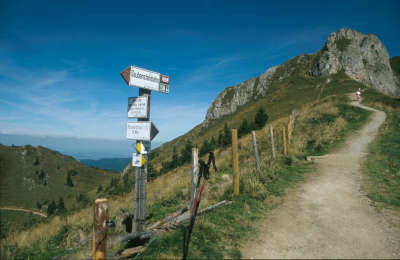
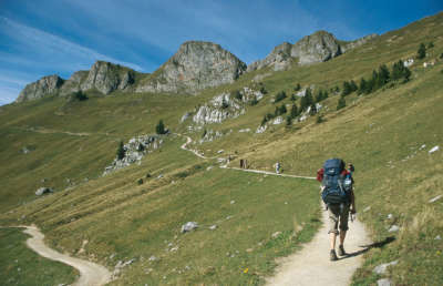
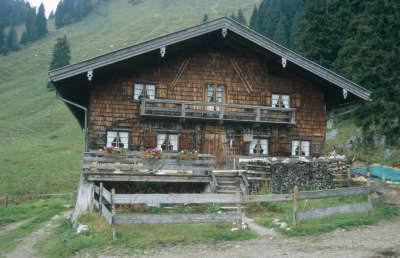
Several trails lead away from the Rotwandhaus lodge. Via Alpina follows the middle one that leads northward to the Taubenstein peak. It starts off on a gentle incline, then levels out and in places heads slightly downhill below the Rotwand peak (to the west) and the Lempersberg past the Taubenstein. Just after this, you will come to the Taubenstein mountain station (approx. 35min). For those who wish to save themselves the descent, it is of course possible to take the Taubenstein lift to the Spitzingsee lake, although the trail over the Schönfeldalm meadow is much more beautiful. From the mountain station of the Taubenstein lift, the trail leads left towards the northwest down to the Obere and Untere Schönfeldalm meadows, where the Schönfeld hut of the German Alpine Club offers accommodation and catering. Head over the pastureland and later through the wood on an easy, slightly downhill course to the Spitzingsattel pass (approx. 1h 20min from the Taubenstein mountain station). Here, follow the road southward to the lake for a short distance. On the western bank, head directly to the south in the lovely setting of the Spitzingsee lake. At the southernmost end of the lake, Via Alpina swings to the right to head westward, for a short distance following a road that soon becomes a path again, which winds its way up alongside the ski slope. Continue uphill to finally reach a dip approx. 150m to the right below the Stümpfling mountain station (1,464m). Then follow the red marks downhill along the ski slope. The trail leads over the Suttenalm and Bäckeralm meadows to Sutten, where the Sutten mountain inn and the Monialm offer accommodation facilities.
From Sutten, head either on foot or with the chair lift to the Stümpfling ski area. From there, walk over the meadowland down to the Spitzingsee lake. Head along the western bank to reach the Spitzingsattel pass, where you must keep to the right to reach the Schönfeldalm meadow.
(Michael Kleider, Christina Schwann, OeAV)
Natural and cultural heritage
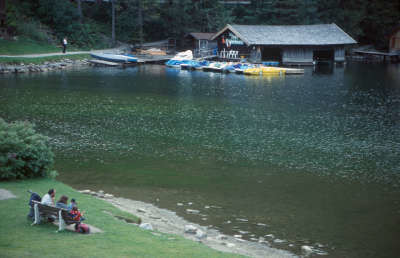
The Spitzingsee lake and the vilage by the same name on its shore are a popular holiday destination in both summer and winter. The lake is surrounded by a wreath of foothills, which are easy to climb in the summer and in winter are suitable for skiing. Spitzingsee belongs to the community of Schliersee, whose origins date back to a monastery founded in the 8th century (“Slyrse”). The parish church of St. Sixtus in Schliersee, which was rebuilt after a fire in 1348, is one of the most beautiful in the region and holds valuable art treasures, such as the carved Gothic throne of grace by Erasmus Grasser and a painted “Schutzmantelmadonna” (the Madonna in her protecting mantle) by Jan Polack (1494). Johann Baptist Zimmermann was responsible for the ceiling frescos and the beautiful stucco work. At the southern end of the Suttenalm meadows, whose terrain is a valuable damp biotope, lies a little artificial lake that was built for the purposes of “Holzdrift” (as the transport of tree trunks by water was called). Raft manufacturing used to be an actual profession that was widespread in the Bavarian alps, but has since died out. The raft-makers used either unbound trunks (“Wilddrift”), or trunks tied together (“Floße”).
(Michael Kleider, Martin Scheib, DAV-Sekt. Tegernsee)
Other long-distance trails and alternative routes
Valley trip from the Taubenstein on the Taubensteinbahn funicular to the Spiztingsee lake, mountain trip from the Spiztingsee lake on the Stümpfling chair lift to the Stümpling, valley trip from the Stümpfling on the Sutten chair lift; ascent of the Rotwand (1,884m), the Roßkopf (1,580m) or the Suttenstein (1,398m)
Useful topographic maps
-
Tegernsee-Schliersee; Mangfallgebirge ~ Bayerisches Landesvermessungsamt München (1:25.000)
-
ÖK 50 89 ~ Bundesamt für Eich- und Vermessungswesen (1:50.000)
-
Nr. 8 Tegernsee - Schliersee - Wendelstein ~ Kompass (1:50.000)
Last update : 2010-11-30

 |
4h00 |
12.4 km
|
500 m
|
1234 m
|
4h00 |
12.4 km
|
500 m
|
1234 m


Favourites, criticisms ? Make your personal comments on this stage. For more general notes please use the comments section of the page Over to the Via Alpinists.