|
|
|
A52
|
Brünnsteinhaus » Rotwandhaus
|
|
This easy but nevertheless quite long stage leads from the much trodden paths of the Wendelstein mountains into the heart of the Schliersee mountains. The initial leisurely hike over the alpine pastures of the Himmelmoosalm is followed by a climb to the Traithen mountain. Then the route leads down into the Ursprungtal valley and on the other side, upwards once more to the Rotwandhaus lodge.
Detailed route description

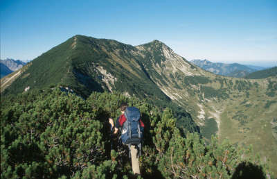
From the Brünnsteinhaus lodge, Via Alpina follows the path westward over the Himmelmoosalm meadow. The trail then branches off to the right to the Brünnstein, which can be climbed in approx. 45min. The last 100m are secured with a rope, but otherwise the trail can be described as easy. Follow the trail westward in the Himmelmoosalm meadow to reach a fork in the road. Here, keep to the right, immediately afterwards following a little track on the left towards the west on a slight incline to the Steilnerjoch pass. From here, continue uphill to 1,747m. At the fork in the road, follow the left-hand track to reach the Steintraithen (summit cross) and head up to the Unterbergjoch pass at 1,828m. Then keep following the uphill track to the Großer Traithen, which at 1.852m is the highest point in this stage. From the Großer Traithen, the trail starts off on a very steep uphill course. Be careful, especially in damp conditions. At the fork in the road, keep to the left to reach Fellalm. Immediately before the meadow, the trail turns left towards the southwest and leads over pastureland, then dipping down into the wood. A long downhill walk follows. Ignore the turnoff to the Benebrandalm meadow on the left. Further downhill, the trail widens out into a little gravel road. This finally leads to another gravel road, on which you must turn right and head westward, after a few hundred metres reaching the main road to the village of Bayrisch Zell at the Schweres Gatter car park. On the other side of the road (direction Bayrisch Zell), walk for around 15 minutes to reach the Silberghaus car park, from where a road leads steeply up to the Silberghaus lodge. From there, a road to the northwest leads further uphill and then meets a forest road. Take this road to the left and immediately afterwards turn right onto another gravel road into the wood (Rotwandhaus inn) to reach the Sandbichleralm meadow, where the little road diminishes into a trail. Then head over the pastureland first on a level course and later on an ascent to a pass on the Maroldschneid mountain. Here, either head over the Auerspitz peak (straight ahead to the north, beautiful view) to the Kümpfelscharte pass, or turn left just after the Maroldschneid to arrive over pastureland at the Kümpfelscharte pass. Then keep to the left to reach the Rotwandhaus lodge.
(Michael Kleider, Christina Schwann, OeAV)
Natural and cultural heritage
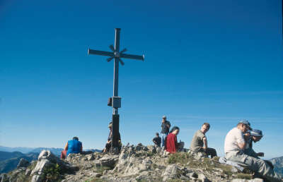
The Rotwand area takes on a special status in the Bavarian Alps, as many various sediment layers were folded and raised there during orogenesis. The differences in the constitution of the individual strata result in the diversity that we can admire today. The reddish colour – caused by dogger pebble limestone on the southeastern side of the summit – gave the mountain its name, while other sediment strata such as the lias (black Jura, predominantly composed of clay and marl) form the many dips in the Rotwand area. The various outcropping rocks of the Rotwand cause variations in the ground formation and are the cause of the enormous plant diversity in such a small space. Thus the following species, among others, find a habitat there: alpenrose, almrausch, yellow bellflower, purple saxifrage, milkvetch and Hungarian gentian. The Rotwand and the neighbouring Hochmiesing are two of the most popular Bavarian prealpine summits, and their ascent can be considerably shortened on the Taubensteinbahn funicular. After a spectacular summit view, the nearby Rotwandhaus lodge to the south below the summit is a popular stopover. (Michael Kleider)
Other long-distance trails and alternative routes
Ascent of the Rotwand (1,884m) in approx. 30min, easy
Useful topographic maps
-
Nr. 8 Tegernsee - Schliersee - Wendelstein ~ Komapss (1:50.000)
-
Mangfallgebirge ~ Bayerisches Landesvermessungsamt München (1:50.000)
-
ÖK 50 90, 89 ~ Bundesamt für Eich- und Vermessungswesen (1:50.000)
Websites relative to natural and cultural heritage
Last update : 2011-08-17

 |
7h05 |
17.8 km
|
1482 m
|
1079 m
|
7h05 |
17.8 km
|
1482 m
|
1079 m


Favourites, criticisms ? Make your personal comments on this stage. For more general notes please use the comments section of the page Over to the Via Alpinists.