Hiking (mountain trail, in places narrow and exposed)
Alpine route (equipped or very exposed section, snow field, blocks)
A47
Marquartstein » Kampenwand Bergstation
|
4h35 |
11.8 km
|
1235 m
|
328 m
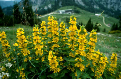
This is a stage with a thoroughly alpine character. At the start, it goes uphill through mixed mountain woodland – alternatively, treat yourself to a trip up with the Hochplatte lift – whereupon the track soon becomes more rocky and somewhat exposed. Via Alpina moves along below the Hochalpkopf and the rocky Raffen, before the little Steinlingalm pasture invites you to have a rest.
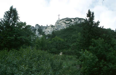
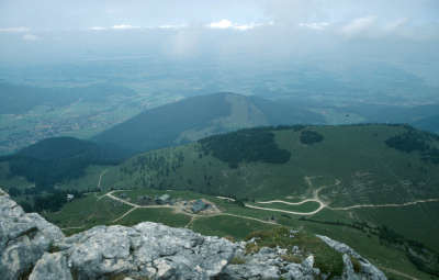
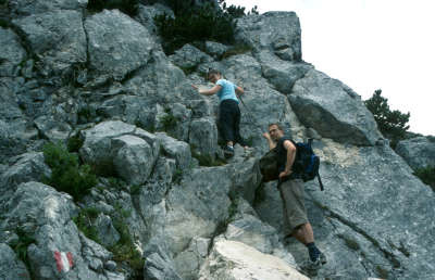
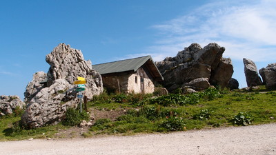
From Marquartstein, the trail leads over the towns of Piesenhausen and Niedernfels to the valley station of the lift to the Hochplatte plateau. This runs from 9am onwards. A trip up is especially recommended if you also wish to tackle the next stage, A48, to the Priener Hut on the same day. Walk to the left above the mountain station (at the public toilets) along the roadway towards the South West and follow the signposting on to the Kampenwand. The roadway leads past the Hochplattenalm meadow, turns to the West and after crossing a little pass reaches the Piesenhausener Hochalm meadow after approx. 3h (without taking the cable car). Via Alpina follows the lovely, open ridge trail, which stretches along past the Grassauer Haus refuge, passing below the Hochalpenkopf to the South and the rocky Raffen peak. Continue northwards then to the eastern foothills of the Kammpenwand. Via Alpina leads along a rocky track – two areas are secured with cables – into the little wind gap between the highest and outermost outlying eastern summit with the Chiemgau summit cross, and heads to the North West once on the other side down to the Steinlingalm meadow (1,550m). For the descent from the summit through the so-called “Kaisersäle” (imperial rooms), you must be sure of foot and free of vertigo. It would be better to stash your hiking sticks in your rucksack, as in parts you will need your hands to help you. The Steinlingalm meadow has catering facilities during the summer months but does not offer accommodation. Once on the promenade, walk along the northern side of the Kampenwand to the “Berggasthof Sonnenalm” mountain inn (reservation for overnight accommodation is advised). (Michael Kleider, Christina Schwann, OeAV)
Natural and cultural heritage
The history of Marquartstein begins with the story of the castle. It was built in the 2nd half of the 11th century by Count Marquart II., and restored in 1857 so as to give an idea of the medieval fortress. Over the centuries, the castle has often changed hands. At the moment, it is in private possession and cannot be visited. According to legend, the architect Marquart died from after being wounded by arrow when he was out poaching on the hunting ground. An expiatory chapel called the Schnappenkirche was erected at the place where he was found. Marquartstein gained renown due to the fact that Richard Strauss composed his most important works here between 1890 and 1908 and wed Pauline de Ahna in 1894 in the castle church. A commemorative plaque in the St. Veit castle church serves as a reminder. Is there a Bavarian who does not know the saying “I gang so gern auf d´Kampenwand, wann i mit meiner Wamp´n kannt”? The Kampenwand peak clearly gives the image of the Chiemgau mountains its character. In Bavaria, a ridge is referred to as a “Kampel”, which is why the jagged ridge rising over the Chiemsee lake is called the Kampenwand.The perpendicular sheer southern precipices of Wetterstein limestone tower steeply out of the roundish, already weathered Flysch mountains and offer outstanding climbing opportunities. Most of the rocks are therefore also reserved for climbers, while the other eastern summit and its 12-metre high Chiemgau cross, which is reached on this stage, left for mountain hikers. However, expect it to be very crowded on good days, when entire armies of people ramble around on the summit. At places secured with cables, there can even be waiting times. Nevertheless, this mountain with its charming paths, meadows and rock faces is well worth the climb, especially as you will quickly find peace and quiet again away from the “Kampenwand mountain station – Steinlingalm meadow – eastern peak” trail. (Michael Kleider)
Other long-distance trails and alternative routes
Detour to the peak of the Kampenwand (trail type E), approx. 90min. If you take the chair lift, this stage can be shortened by approx. 45min. Maximiliansweg, E4
Useful topographic maps
L 8340 Ruhpolding ~ Bayerisches Landesvermessungsamt München (1:50.000)
L 8240 Marquartstein ~ Bayerisches Landesvermessungsamt München (1:25.000)
Nr. 10 Chiemsee - Simssee ~ Kompass (1:50.000)
Useful guidebooks
Der Maximiliansweg ~ GeoCenter Medienservice Stuttgart (ISBN 3-930187-08-6)
Favourites, criticisms ? Make your personal comments on this stage. For more general notes please use the comments section of the page Over to the Via Alpinists.
DAV-Achental - 2013-06-03
Der Weg Nr. 66, E 4, Maximiliansweg und Via Alpina ist zwischen Piesenhauser Hochalm und Raffen an zwei Stellen abgerutscht. Einmal ca. 10m und einmal ca. 50m. Eine Begehung ist möglich, das Risiko abzurutschen ist aber hoch. Eine Reparatur ist frühesten im Juli möglich da die Stelle durch den Dauerregen sehr nass und die Instandsetzung auch nicht einfach ist.
Automatic translation
[Google]
The way No. 66, E 4, and Maximiliansweg Via Alpina is slipped between Piesenhauser mountain pasture and shirring in two places. Once again 10m and 50m. An inspection is possible, but slipping the risk is high. A repair is possible in July since the earliest point is not simply due to the continuous rain very wet and repair.
cr3149 - 2012-06-11
Der Weg ab der Piesenhauser Hochalm ist nach wie vor sehr schlecht und mit einzelnen Schneefeldern, teilweise auch gefährlich, weil er wirklich sehr abschüssig ist. Die anschließende Etappe wie empfohlen zu Priener Hütte an einem Tag zu schaffen, ist meiner Meinung nach nicht möglich, auch nicht mit Lift.
Automatic translation
[Google]
The path from the Piesenhauser Hochalm is still very poor and with isolated snow fields, sometimes dangerous because it is very steep indeed. Create the subsequent stage as to Priener Hut in a day is recommended, in my opinion, not possible, not even with a lift.
Liebl Georg - 2009-08-10
für Dienstag, den 02.06.09 hatten wir uns mit 3 Erwachsenen u. 1 Kind beim Etappenziel Berggasthof Sonnenalm zum Übernachten angemeldet. Leider mußten wir bei unserer Ankunft um 18 Uhr feststellen, dass alles zugespert war. Ein Etappenziel sollte auch ohne Anmeldung geöffnet sein.
Außerdem war der Weg von der Piesenhauser Hochalm zur Kampenwand in einem nicht zumutbaren Zustand. Der Weg bestand meist nur aus einem steilen "Letten-Hang", der auch mit Stöcken äußert schwer zu begehen war. Eine Wegsanierung ist hier unbedingt erforderlich.
Liebl Georg
Automatic translation
[Google]
for Tuesday, 02/06/09 we had registered with 3 adults and 1 child in milestone Berggasthof Sonnenalm to stay. Unfortunately we discovered when we arrived at 18 clock that everything was zugespert. A milestone should be opened without registration.
Moreover, the path of the Piesenhauser Hochalm the Kampenwand was not in a reasonable state. The trail consisted mostly of a steep "Letten-slope" which was difficult to commit even with sticks expresses. A Wegsanierung is essential.
Georg Liebl

 |
4h35 |
11.8 km
|
1235 m
|
328 m
|
4h35 |
11.8 km
|
1235 m
|
328 m


Favourites, criticisms ? Make your personal comments on this stage. For more general notes please use the comments section of the page Over to the Via Alpinists.