Hiking (mountain trail, in places narrow and exposed)
Alpine route (equipped or very exposed section, snow field, blocks)
A34
Theodor-Körner Hütte » Lungötz
|
5h50 |
19.2 km
|
334 m
|
968 m
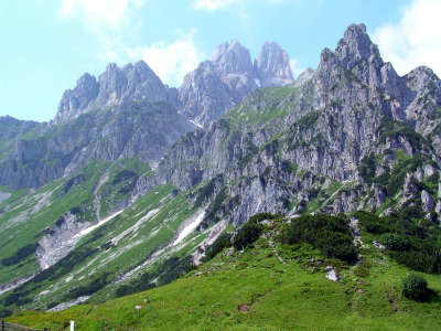
Still in the mighty Dachstein mountains, with the Gosaukamm ridge on your left-hand side, the well-known Bischofsmütze (2,458m) soon comes into sight. Once the climb to the Stuhlloch has been completed, the pace gets more comfortable upon reaching the turn-off to the Hofpürgl hut, where you can have a rest. The trail then continues across alpine meadows and through woodland down into the Lammertal valley.
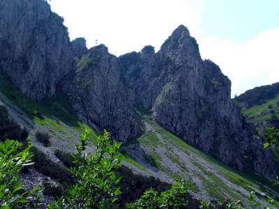
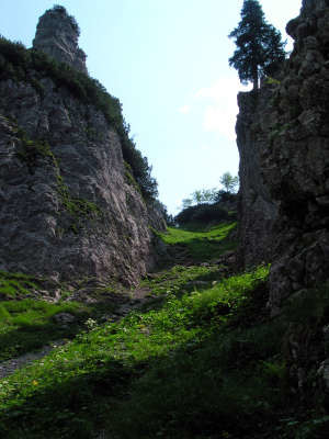
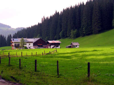
From the Theodor-Körner-Hut, go back a little to the Stuhlalm meadow and keep to the right at the fork in the road in the direction of the Hofpürgl Hut. The track first leads downhill a little and then through the pines following the sloping ridge until entering into the Stuhlloch rift. The trail continues in very narrow, very steep bends – it is secured with wire cables – up wooden steps anchored painstakingly in the gravely earth. Once this steep stretch of the way is behind you, there is a lovely walk to the West of the Gosaukamm ridge that is characterised everywhere by the impressive mountain panorama of the Große and Kleine Bischofsmütze peaks. Walk at a leisurely pace over the Mahdalm meadow, where not only cows but also horses enjoy the summer months. Finally, you will reach the "Sulzkaralm" turnoff, but continue straight ahead and follow the path to the Hofpürgl Hut. Soon after this, you will arrive at the "Lungötz" turnoff, which should first of all be ignored, if you wish to make the detour to the Hofpürgl Hut. This little detour of approx. 1h there and back is by all means worth while, as the refuge stands directly in front of the Dachstein mountains and offers the ideal starting point for numerous alpine outings (approx. 2h 30min). After some hearty refreshments at the refuge, follow the path back to the "Lungötz" turnoff. Here, turn left across the alpine meadowland until reaching the edge of the wood, where you must keep to the right. The trail leads downwards through the wood until coming to the Arzbergalm meadow after approx. 1h. Here, turn left through the cattle gate and then immediately right along the fence. The route again goes down through woodland until reaching a forest path. Follow this now outwards until you have left the entire Neubachtal valley. From Neuhaus, the gravel road turns into an asphalt road. Opposite the little ski lift, Restaurant "Wiesenalm" invites you to stop for afternoon coffee before reaching the little village of Lungötz after a total of 3h 30min from the Hofpürgl Hut. On arriving at the Arzbergalm meadowland, turn sharply to the left, walk through the cattle gate and then head immediately uphill to the right. (Christina Schwann, OeAV)
Natural and cultural heritage
On the trail to the Hofpürgl Hut, just after the steep ascent through the Stuhlloch valley, you will come across a sign for the Arnoweg trail. This long-distance trail in the province of Salzburg was built on the occasion of the 1,200 year anniversary of the Archbishopric of Salzburg. The trail bears the name of Bishop Arno, who in 798 was promoted by the Pope to Archbishop on the instruction of Charlemagne. The trail route, however, not only focuses on the church history but also ties in numerous countryside specificities, from the summits of the Dachstein to the cultural historic highlights of the province of Salzburg. While this 6th section of the Arnoweg trail leads from the Theodor-Körner Hut to the Hofpürgl Hut and on to Annaberg, Via Alpina heads downhill to Lungötz. But once in Werfen on the way to the Mitterfeldalm meadow, the Arthur Haus lodge and the Erich Hut, the route once again follows the Arnoweg trail. A short detour takes you to the Hofpürgl Hut. The well-known photographer Karl Wurm, member of the Linz section, encouraged the construction of this hut at about the turn of the century. Located at the Hofpürgl, a verdant foothill of the Mosermandl, the hut offers an ideal starting point for climbing the Große and Kleine Bischofsmütze peaks. In the 100-year history of the hut, the 15 September 1993 remains in all mountaineers’ memories as a fateful day. 100,000 tonnes of rock thundered down from the peak of the Bischofsmütze. One of the most popular climbing tours on the peak was thereby relegated to history books. Today, the Austrian Alpina Club offers professional climbing courses right beside the hut – directed mainly at young people. Deadly mountain accidents, as occurred very frequently in the past, are now a rare occurrence. Alongside the breathtaking summits, the Dachstein-Rieseneishöhle and Dachstein-Mammuthöhle caves are certainly among the major natural wonders of the Dachstein region. The Rieseneishöhle cave is one of the biggest ice caves on Earth. With approx. 30,000m³ of ice, which in the Tristan Dome reaches a thickness of 25m, it is the main touristic point of attraction in the Salzkammergut district. The second very well-known cave is the Mammuthöhle, a passage system of over 60km in length. 1km is accessible to visitors and offers an insight into the life of the mining community, with a journey back in time from the beginning of speleology until today. At then of this day of hiking, the trail reaches the hamlet of Lungötz, which belongs to the community of Annaberg-Lungötz. The little hamlet is situated at an altitude of 850m. Nestled between the Dachstein and Tennengebirge mountains, the hamlet was already mentioned in the year 1124 by the deed of donation, in which Archbishop Konrad I transferred the left bank of the Lammer river to the monastery of St. Peter. (Christina Schwann, OeAV)
Other long-distance trails and alternative routes
north alpine long-distance hiking trail 01, from the Neusiedlersee lake to Lake Constance. Arnoweg
Favourites, criticisms ? Make your personal comments on this stage. For more general notes please use the comments section of the page Over to the Via Alpinists.
Wir sind den Weg zur Hofpürglhütte gegangen, fanden ihn aber überflüssig , die Hütten ist unpersönlich, eine Massenabfertigung. Die Aussicht ist schön, doch dafür 1Stunde hin und zurück????. Besser gleich dem Hinweis nach Lungötz folgen
Automatic translation
[Google]
We went the way to the Hofpürglhütte, but found it superfluous, the huts are impersonal, a mass processing. The view is nice, but for 1 hour round trip ????. Better to follow the hint to Lungötz
Da wir in Lungötz kein Zimmer fanden fuhren wir mit dem Bus nach St. Martin (ca.4 km) und fanden in der Pension Edelweiss, 0664 2528784 ein nettes Zimmer. Auf Empfehlung des Wortes stiegen wir nächsten Tag über die Buttermilchalm zum Oistermaisspitz auf und gingen über den Frommer Kogel wieder auf den original Weg der Via Alpina.
Automatic translation
[Google]
Since we did not find a room in Lungötz we went by bus to St. Martin (about 4 km) and found in the Pension Edelweiss, 0664 2528784 a nice room. On the recommendation of the word we climbed the next day on the Buttermilchalm Oistermaisspitz and went over the Frommer Kogel back on the original path of the Via Alpina.
Mountain Girl - 2013-10-26
In Lungoetz I recommend the rooms for rent at Haus 126 (big yellow house on left as you're coming into Lungoetz). Roswitha & Georg Schwarzenbacher are wonderfully warm, kind people.

 |
5h50 |
19.2 km
|
334 m
|
968 m
|
5h50 |
19.2 km
|
334 m
|
968 m


Favourites, criticisms ? Make your personal comments on this stage. For more general notes please use the comments section of the page Over to the Via Alpinists.