S.I.C. M. Toraggio-M. Pietravecchia, Gouta-Testa d'Alpe-Valle Barbaira
Key to symbols
Stage point (start or end of stage)
Intermediate accommodation possibility
Summit
Pass
Town, village
Other locality
Catering
Doctor
Chemist
Bakery / grocery
Hardware / sports shop
Post
Bank / cash dispenser
Train
Coach
Taxi
Open automobile access
A
Tarred or paved road
B
Dirt track
C
Mule trail
D
Mountain trail
E
Equipped trail (cables, ladders)
F
No trail
Stroll / tourism (broad, non-exposed trail)
Hiking (mountain trail, in places narrow and exposed)
Alpine route (equipped or very exposed section, snow field, blocks)
R157
Colla Melosa » Saorge
|
6h40 |
22.9 km
|
565 m
|
1655 m
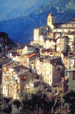
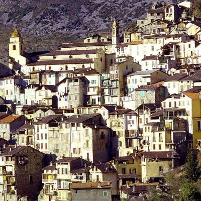
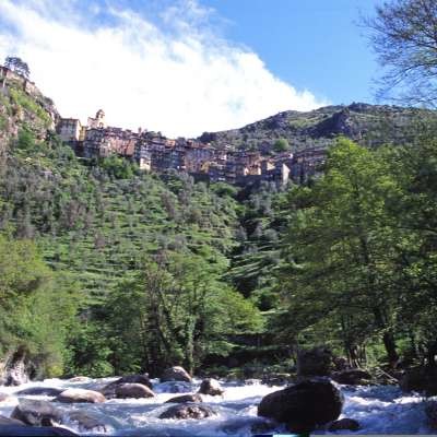
Leaving the Melosa pass, the trail climbs to the Valletta pass. It flirts with the border crest on the French side, apart from a brief return to Italy in the vicinity of Mt Toraggio with its straight, dolomite-like rock faces. At the Corvo pass, Via Alpina enters France once and for all, descending after the Muratone pass through woodland to the beautiful hanging village of Saorge.
From the Melosa pass, follow the road as it climbs northwards for about 300 metres, and then take the bridleway that turns right up the southern slopes of Mount Grai until it meets the road again, just below the Grai hut. Turn left onto the road and follow it a short way to the Sella d'Agnaira pass, (B. Vallette, 1880m). Turn right onto the track that climbs towards the peak of Mount Pietravecchia all the way to the Valletta Pass (1909m) on the border. Follow the red and white signs of the Alta Via dei Monti Liguri trail down the French side of the border, past a rocky patch and circling Mt Pietravecchia to the west, to reach the Gola dell'Incisa pass (1684m). The trail then forks. To the left lies the Sentiero degli Alpini trail (see alternative routes). Instead, continue along the French slopes of Mount Toraggio, along a bridleway that cuts across the slope through larches. Once over the Fonte Dragurina Pass (1821m) we are in Italian territory once again. The bridleway winds dramatically through fields and rocks. It then turns westwards sharply, cutting straight across a rock face to the Gola del Corvo pass (1404m), hewn out of the rock. From the Gola del Corvo pass the trail heads east on the Italian side of the mountain. It then forks. To the right is the Sentiero degli Alpini trail (see alternative routes). Instead, take the other fork that climbs to the Fonte Dragurina Pass. It circles Mounts Toraggio and Pietravecchia on the French side and then climbs to the Valletta Pass (1909m). The trail then descends briefly on the Italian side only to climb again towards the Grai hut. Finally take the fork on the right, a bridleway that descends to the Melosa pass. (Regione Liguria)
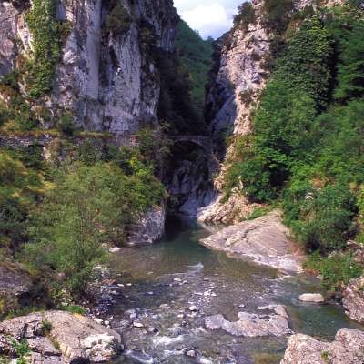
Take the track on the French side of the border in a westward direction, marked in yellow. It winds its way through a beautiful pine forest, crosses the little Casagionna valley and climbs back up to reach a little pass where the Madonina wayside shrine is situated (marker 169). Leave the track in favour of the path that descends to the north, winding along a steep slope in the forest (marked in yellow). Cross the little Madonina valley to pass onto its left-hand bank and about 300m further, at marker 166, continue in the same direction, leaving the path that descends into the valley on your right. The path overlooks the little Bendola valley, before crossing it on the Castou bridge to reach a road. Keep following the yellow markings and take the path that leaves to the right above the road. It runs above it for about 2km and then joins it after the Pranier valley. Continue along the road in a westward direction, cutting across the first hairpin bend on a short pathway and then continue until reaching a tarmac road that joins the GR® 52A trail, marked in red and white. Follow the road to the north east, passing in front of the cemetery and continuing to the north to enter the village of Saorge. The entrance to the village is at Rue Perrissol, in the direction of the post office. (Paul Guglielmi, CDRP 06)
Natural and cultural heritage
The position of Mounts Toraggio and Pietravecchia, placed as they are between the Alps and the Mediterranean, means that they are blessed with a rich diversity of plant life. Mediterranean species are to be found alongside alpine varieties or even arctic plants that became established here eons ago when most of the Alps were covered by glaciers. In late spring and early summer the hills are a vision of flowering blooms. In the autumn it is the turn of the larch forests to dazzle the walker with colour. And you might just catch a breath-taking glimpse of a chamois, framed by the backdrop of the sea. (Regione Liguria)
Other long-distance trails and alternative routes
Alta Via dei Monti Liguri. Climb to Monte Toraggio (for expert hikers). Variant on the Sentiero degli Alpini (for expert hikers).
Favourites, criticisms ? Make your personal comments on this stage. For more general notes please use the comments section of the page Over to the Via Alpinists.
Lange, landschaftlich sehr eindrückliche Etappe. Vom Passo della Valletta bis über den Col de Muraton erfordert der Weg über weite Strecken erhöhte Aufmerksamkeit, da ein Stolpern folgenschwer wäre. Ich würde den Schwierigkeitsgrad eher auf Stufe 3 setzen. Beim Col de Muraton war der Pfad im September 2022 an einigen engen Stellen unangenehm zugewachsen. Auf Schlangen achten, wir haben zwei gesehen. Das Tagesziel Saorge ist ein sehr eindrückliches, wunderschönes Bergdorf.
Hinweis: Die detaillierte Wegbeschreibung (Stand 2022) ist fehlerhaft und irreführend, da mittendrin - in kursiver Schrift - plötzlich wieder die Gegenrichtung beschrieben wird.
Klaus - 2019-08-11
Hallo Wanderfreunde,
nach unserer Rückkehr von der VA Rote Garessio > Monaco folgende Bemerkung:
Die Beschreibung der Etappe R157 ist korrekt bis auf Gehzeit und kumulative An/Abstiege.
Basierend auf dem gpx-Track lt. Website beträgt der Anstieg 1249 m (nicht 565 m) un der Abstieg 2287 m (nicht 1655 m); daraus ergibt sich eine Gehzeit deutlich über 6h40 (wir haben (ohne Pausen) 8h00 gebraucht).Start Colle Melsa/Rif. Franco Allavena, Ziel Saorge/ GdE de Bergeron.
Soolte man für die Planung wissen.
Gruß
Klaus
Automatic translation
[Google]
Hello hikers, on our return from the VA Red Garessio> Monaco following remark: The description of the stage R157 is correct except for walking time and cumulative on / off. Based on the gpx track according to the website, the climb is 1249 m (not 565 m) and the descent is 2287 m (not 1655 m); this results in a walking time well over 6h40 (we used (without breaks) 8h00) .Start Colle Melsa / Rif. Franco Allavena, destination Saorge / GdE de Bergeron. Soolte you know for the planning. Greetings Klaus
Le sentiero degli alpini est à flanc de montagne avec de belles vues sur l'horizon, à certains endroits jusqu'à la mer. Après le col du corbeau on passe en France, il y a peu d'indication, et c'est très long pour arriver au beau village de Saorge, terme de cette traversée commencée au refuge de Vens dans la haute Tinée.
Automatic translation
[Google]
The Sentiero degli Alpini is a mountainside with beautiful views of the horizon, in some places to the sea. After we pass raven neck in France, there is little indication, and it is very long to reach the beautiful village of Saorge, the end of this journey began in Vens refuge in the upper Tinée.
Very pretty walk, from begin to end! I walked from Saorge to Melosa.
You can split the walk in two. Near Passo Muratone there is a very nice refuge / restaurant / bar: Passo Gouta Bar Ristorante. Open in summer. It's a 40-minutes flat walk from Passo Muratone. Check 335 539 3560 or 0184 241 068 or 0184 241 016 (village).

 |
6h40 |
22.9 km
|
565 m
|
1655 m
|
6h40 |
22.9 km
|
565 m
|
1655 m


Favourites, criticisms ? Make your personal comments on this stage. For more general notes please use the comments section of the page Over to the Via Alpinists.