Hiking (mountain trail, in places narrow and exposed)
Alpine route (equipped or very exposed section, snow field, blocks)
A33
Gosau » Theodor-Körner Hütte
|
4h05 |
13.1 km
|
844 m
|
156 m
Via Alpina alternates here between woodland and alpine pastures, taking the hiker on the so-called Herrensteig walking trail to the Gablonzer hut, which not only offers an impressive view over the Vorderer Gosausee lake, but is also a starting point for the climb up to the vantage point of the Großer Donnerkogel (2,055m), and also for numerous climbing routes in the Gosaukamm ridge.
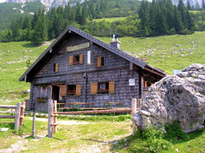
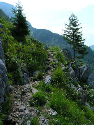
In Gosau, go up to the Kalvarienkirche church. To the left behind the chapel, a little track leads to the so-called "Herrensteig" track bearing the numbers 611 and 601A (also the indication "Austriaweg"), which leads to the Zwieselalm meadow on the left and the Gablonzer Hut. The track starts off winding through woodland on a slight incline, then becomes flatter and follows the sloping ridge for a considerable distance, occasionally crossing little wooden bridges. The forest path must be crossed once, although the turn-off into the wood is well marked and cannot be missed. Finally, walk for a short while along the forest path. The Gosaukamm ridge is already within reach and then turn right over several wooden steps again on an uphill track. You will be tempted to linger at a comfortable resting place offering benches and tables and an impressive view over the Gosaukamm ridge and the deep green Gosausee lake. Continue along the track further up through the wood, cross the ski slope and just afterwards you will first reach the Lutgebalm meadow, then the forest road and the Falmbergalm meadow. You must walk for a while along the forest road, but a path into the wood soon branches off to the right again. Cross marshy meadows and little wooden bridges before reaching the Gosau ski area. Here, cross the ski slope and keep to the left following the signposting for the Gablonzer Hut, while the path to the Zwieselalm meadow continues straight ahead. Until arriving on a small roadway, the trail is once again quite steep but the view over the Gosaukamm ridge is fascinating. The Gablonzer Hut can already be seen now, with its summer terrace which offers the best view over the Gosausee lake. After a short distance and approx. 2h 50min, you will reach the alpine club refuge. Leaving from the refuge, follow the signposting uphill in the direction of "Donnerkogel" and "Theodor-Körner-Hut". The Donnerkogel can be accessed via a climbing track, but cannot of course be used without the correct equipment. After the cattle gate, the trail leads downwards and bends off to the left. West of the Donnerkogel, on its softer side so to speak, the track now continues along the slope. Initially, the vegetation is surprisingly luxuriant and the stones are mostly moist and slippery. Then the character of the terrain changes and you will be crossing uncultivated land covered in loose gravel, until heading down again into the wood. Shortly afterwards comes the Stuhlalm meadowland, on which the Theodor-Körner-Hut stands rather hidden away to the right behind a little copse (approx. 1h to 1h 30min). In front of the Gablonzer Hut, follow the footpath to the left and then turn off downhill to the right. You must soon turn to the right off the broad path and onto a narrow track that leads steeply downwards. (Christina Schwann, OeAV)
Natural and cultural heritage
The Dachstein-Gosaukamm mountain region is situated in the federal provinces of Upper Austria, Salzburg and Styria. In the north, the area reaches as far as the Gosautal valley, the Trauntal valley with the Halltättersee lake and the Aussee area, and in the south to the Ennstal valley, while the western neighbour is the Tennengebirge range, which Via Alpina also touches on at a later stage. The Gosaukamm ridge thus stretches out over 20km in a north-south direction and over 50km in an east-west direction. The Gosaukamm ridge is composed of Dachstein reef limestone and rises up to 2,279m on the Mandlkogel peak, 2,415m at the Großwand, reaching its greatest height at its southern end on Salzburg territory in the Bischofsmütze double peak; the Große Bischofsmütze at 2,458m and the Kleine Bischofsmütze at 2,430m. The newly built via ferrata to the Donnerkogel peak is very impressive, but must only be used by experienced mountaineers with the appropriate equipment. The beautiful setting of the Theodor-Körner Hut with a glorious valley view and a mountain panorama on the Stuhlalm meadow was awarded the environment quality mark by the Austrian Alpine Club in 2003. Many little details such as the dry toilets, the water treatment method and the solar energy panels led to this great distinction. And, incidentally, you will rarely find another hut serving food as good as the food in the Theodor-Körner Hut, which can be enjoyed on the lovely sunny terrace in one of the pleasant basket chairs. (Christina Schwann, OeAV)
Other long-distance trails and alternative routes
"Donnerkogel" via ferrata, only for experienced hikers, possibly also with a mountain guide. Information and reservations in the Gosau tourist office. north alpine trail 01
Useful topographic maps
Nr. 14 Dachstein ~ Oesterreichischer Alpenverein (1:25.000)
Favourites, criticisms ? Make your personal comments on this stage. For more general notes please use the comments section of the page Over to the Via Alpinists.

 |
4h05 |
13.1 km
|
844 m
|
156 m
|
4h05 |
13.1 km
|
844 m
|
156 m


Favourites, criticisms ? Make your personal comments on this stage. For more general notes please use the comments section of the page Over to the Via Alpinists.