|
Create your own guidebook
Location
Key to symbols

|
 |
6h55 |
15.55 km
|
1560 m
|
879 m |
6h55 |
15.55 km
|
1560 m
|
879 m
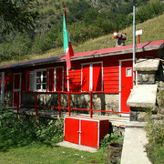
From Pontebernardo the trail heads westwards, about halfway up the slope, through a dip near the Becchi Rossi peaks, and then down to Prati di San Lorenzo, on the banks of the Forneris stream. Once over the Stau pass it leads back down to the Ponte Bernardo valley and near the Talarico hut. The trail then leads up the opposite slope to the Sottan delle Scolettas pass, followed by a brief descent to the Zanotti hut. This leg is practicable by mountain bike, too from Zanotti Refuge to Pontebernardo (don’t go up to Stau pass; once you get to Malarico you’ll have to go down directly along the valley of Pontebernardo; Zanotti refuge can be reached through the military road from Pietraporzio).
Other long-distance trails and alternative routes
Sentiero Italia trail. Useful topographic maps
Useful guidebooks
Websites relative to natural and cultural heritage
Tourist offers
Last update : 2019-12-17
|
|||||||||||||||||||||||||||||||||||||||||||||||||||||||||||||||||||||||||||||||||||||||||||||||||||||||||||||||||||||||||||||||||||||||||||||||||||||||||||||||||||||||||||||||||


Favourites, criticisms ? Make your personal comments on this stage. For more general notes please use the comments section of the page Over to the Via Alpinists.