Hiking (mountain trail, in places narrow and exposed)
Alpine route (equipped or very exposed section, snow field, blocks)
A30
Pühringer Hütte » Loserhütte
|
7h10 |
19.7 km
|
740 m
|
841 m
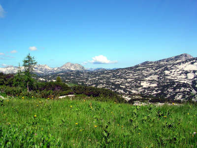
This stage is likewise heavily influenced by the karstic landscape of the Tote Gebirge mountain range. The first part up to the Albert-Appel Haus lodge leads across rocky, open terrain, broken up in parts by expanses of mountain pine. Only after this does the route head downhill, reaching the edge of the woods and dipping into the shadows of the trees.
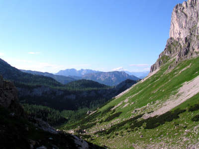
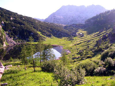
From the Pühringer Hut, walk alongside the Elmsee lake and then slightly uphill to "Emils Tränenhügel" hill. From there, go through a pretty mixed mountain wood with larches and cembran pines and thick undergrowth to the Elmgrube, on which several little alpine huts are situated. Just behind the first hut, the trail branches off sharply to the right towards the Albert-Appel-Haus refuge. From here, the trail leads steadily uphill, first through pines and later increasingly over open terrain at the foot of the Salzofen Cave. It takes a good 45 min to walk from the Elmgrube to the Abblasbühel mountain. At the Abblasbühel, the trail flattens out again and leads over sometimes marshy meadows with cotton grass and marsh marigolds. Finally, the trail reaches the turn-off to the Wildgößl mountain, although Via Alpina opts for the trail that circumvents it. The view over the vast terrain of the Tote Gebirge mountain range is wonderful and a little further down, the Wiesenlacke rift, to which the trail now descends, can already be seen (approx. 1h from the Abblasbühel). From here, walk along a gently undulating route past the "Schlund" (chasm) that opens up on the right-hand side to the Jägerbründl spring, which eventually offers another chance to fill your water bottles. Now, the “Redender Stein” (talking stone) can already be seen with its summit cross and the trail heads downhill into the "Katzenmoos", where several alpine huts are situated. Only a little stretch further to the Albert-Appel-Haus refuge, which is already waiting with lunch (approx. 4h from the Pühringer Hut). The refuge is in a very lovely setting and initially offers a view over the Dachsteingletscher glacier. From the refuge, continue downwards, where you must keep right at the first turn-off in the direction of "Loser". Head through sparse mixed woodland with larches, cembran pines and spruce trees down over boulder rocks, until the "Augstwiesenalmen" meadows appear. Follow the trail downwards and across the "Augstwiesen" meadows until reaching the other side and heading uphill to the Hochklapfsattel pass (approx. 1h 30min from the Albert-Appel-Haus). Directly at the pass, the "Karl-Stöger-Steig" trail branches off to the right. It continues for a while up through mountain pines and over several ledges, until you arrive on a track that is partially secured with wire cables alongside the rock faces of the Vorderer Schwarzmooskogel peak at a more or less even altitude with a wonderful view over the Altausseer lake (you must be sure of foot and free of vertigo). A large hole in the rock face heralds the nearby ice caves, as an ice-cold gust of air flows from the opening, causing you to shiver even on hot days. A short uphill walk will finally take you to the Loser area. Here, keep somewhat to the right and follow the path towards Augstsee and not directly to the upper car park in the self-service restaurant. The trail then passes the lake above the panoramic road directly down to the Loser Hut, which belongs to the Alpine Club, and not only offers all the comforts of a hotel but also a splendid view (2h 40min from the Hochklapfsattel pass). (Christina Schwann, OeAV)
Natural and cultural heritage
In order to preserve the unique landscape of the Tote Gebirge range with its highly diverse flora and fauna in the long term, the part of the Tote Gebirge situated in the communities of Altaussee and Grundlsee was declared a nature reserve on decree of the Styrian provincial government of 27 May 1991. After the first point on this stage, the Albert-Appel-Haus refuge, the trail reaches the Augstwiesenalm meadow, which consists in a total of 20 little pastureland huts. The name could possibly derive from the Roman term "Augusta", as the Roman mining settlement at the Michlhallberg on the southern side of the Sandling and numerous dispersed discoveries testify to considerable human activity in Roman times. On the meadows of the Tote Gebirge, however, no discoveries from this era have been found as yet. From the stage destination of this tour, the Loser Hut, a fantastic view over the Dachstein and the Altaussee lake can be enjoyed. The Aussee region has obviously always held astonishing powers of attraction over artists of all sorts. The Via Artis trail in Altaussee allows hikers to experience their creative skills. Altaussee has been a climatic health resort since 1989. A visit to the Altaussee spa house with the drinking well of the Glauber salt spring, open-air brine inhalation complex and graduator can only be beneficial to one’s health. (Christina Schwann, OeAV)
Other long-distance trails and alternative routes
north alpine trai l 01, European long-distance hiking trail E4; Alternative: turn left before Abblasbühel, climb to the Wildgößl (2,062m). Just after the Wiesenlucke, the trail meets Via Alpina again. Ascent of the Loser (1,837m)
Useful topographic maps
15/1, Totes Gebirge West ~ Oesterreichischer Alpenverein (1:25.000)
WK 082, Totes Gebirge ~ Freytag&Berndt (1:50.000)
Nr. 19 Almtal, Steyrtal, Totes Gebirge ~ Kompass (1:50.000)
ÖK 50 96, 3212 ~ Bundesamt für Eich- und Vermessungswesen (1:50.000)
Favourites, criticisms ? Make your personal comments on this stage. For more general notes please use the comments section of the page Over to the Via Alpinists.
bergziege - 2012-09-10
Abzweigung zum Wildgößl links nicht rechts wie es mir passiert ist. Dadurch bin ich am Almsee gelandet
Automatic translation
[Google]
Turnoff to the left Wildgößl not right as it happened to me. As a result I ended up at the mountain lake

 |
7h10 |
19.7 km
|
740 m
|
841 m
|
7h10 |
19.7 km
|
740 m
|
841 m


Favourites, criticisms ? Make your personal comments on this stage. For more general notes please use the comments section of the page Over to the Via Alpinists.