Hiking (mountain trail, in places narrow and exposed)
Alpine route (equipped or very exposed section, snow field, blocks)
R118
Cérellaz » Valgrisenche
|
6h00 |
19.013 km
|
870 m
|
334 m
The trail descends rapidly from Cérellaz down the slope of the central valley of Aosta Valley. It passes through a number of villages, crosses the Dora Baltea river and climbs Valgrisenche valley. It passes through fields, woods and villages and the Lac Lolair nature reserve. Look towards the end of the valley for a glimpse of the imposing Beauregard dam.
From Cerellaz the trail heads rapidly down into dense woods, through the villages of Le Pré, La Forge and La Ravoire, and on along a stretch of road to Avise. Carry on through the town and from just below the church the old road to Runaz begins. It is now nothing more than a trail. Cross the old bridge over the Dora Baltea stream. This is now the western slope of the main valley of Aosta Valley. The trail passes the main road, the railway station and then Runaz. From Runaz, carry on along a farm road to Pesse and, after a couple of bends, a sign marks the beginning of trail 20. The trail cuts through fields, woods and the villages of Rochefort and La Ravoire. It then enters the Lake Lolair nature reserve, a beautiful natural oasis. The trail then passes through carefully cared for fields, woods, some scree slopes, a rocky area and the villages of Baise Pierre and Milliéry to reach the area of Baulin. Then on to La Clusaz and, from here to Planaval, following the Alta Via no. 2 trail in Aosta valley. It passes through Revers, Prariond, Céré, La Béthaz and Planté. Some of the time the route follows the road, at others there is a trail running alongside the main road to Valgrisenche valley. At the bottom of the valley is the imposing wall of the Beauregard dam. (Regione Autonoma Valle d’Aosta)
Natural and cultural heritage
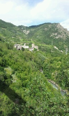
Avise belonged to the noble family of Avise, one of the most important families of Aosta Valley, throughout the middle ages and until 1729. There are three castles here: first of all Avise (dating from the end of the 15th century) notable for its square tower and a series of twin lancet windows; the second is that of Blonay (1100m), which sits strategically atop a rocky outcrop; the third is that of Cré, a 10th century stronghold of which only the crumbling outer walls remain. After Avise there is Runaz, home to the quarry from where the rock was taken for the building of the Roman road to Gaul, which went over the Piccolo San Bernardo pass. At Runaz is Maison de Mosse, an exhibition centre which usually hosts exhibitions related to the mountains and the cross-border character of Aosta Valley. The trail cuts through the Lolair nature reserve and the lake. This is a low mountain ecosystem containing marshlands, home to reptiles such as the grass snake (natrix natrix) and the western whip snake, some amphibians and a wide variety of insects; and an arid steppe like area, home to the extremely rare Pontentylla pensylvanica. This reserve is the alpine area where it is most found. It contains dwarf pine, juniper bushes and rare examples of sedge. The valley of Valgrisenche, where this stage ends, is an extremely ancient settlement. In the middle ages it belonged to the Avise family and was a mining centre thanks to the copper mines in the village of La Béthaz. Today the main activities are cattle rearing, handicrafts and tourism. Visit the Cooperativa Les Tisserands, where draps, traditional wool fabric, is woven on ancient looms. It is available for sale on site. There are two unmissable events: the Tour du Lac, a walking race around Lake Beauregard, in August, and the Bataille des Reines (tussle between pregnant cows), which usually takes place on the second Sunday in September. The Beauregard dam was begun in the 1950s. in order to complete the work, in 1952, 7 villages had to be evacuated and were covered by the water. Five of them are still under water and the remaining two (due to geological problems which led to the artificial lake being partially emptied) have reappeared and are now spooky ghost villages. The dam is over 100 metres high and encloses a lake that is 4 km long. It provides water mainly for the Avise power station in the central part of Aosta valley.
(Regione Autonoma Valle d’Aosta)
Other long-distance trails and alternative routes
Alta Via trail 2; Haute route des Glaciers trail.
Useful topographic maps
Gran Paradiso ~ Kompass (1:50.000)
Parco Nazionale del Gran Paradiso ~ Istituto Geografico Centrale (1:50.000)
Carte n° 2 e n° 3 ~ L'Escursionista editore (www.escursionista.it) (1:25.000)
Useful guidebooks
Guida n° 4-Le Valli del Gran Paradiso e la Valgrisenche ~ Guide dell'escursionista (ISBN )
I laghi della Valle d'Aosta, Sergio Piotti. ~ Ferrari editore (ISBN )
Picture gallery
Add your own pictures!
Comments
Favourites, criticisms ? Make your personal comments on this stage. For more general notes please use the comments section of the page Over to the Via Alpinists.
Berta - 2018-07-28
In Planaval gibt es ein Hotel welches sehr nett und einladend ausschaut, wir haben in Valgrisenche im Le Vieux Quatier ( Tel: 0039016597199) genächtigt, sehr angenehm, ruhig und freundlich. Der Wirt hat sogar für uns im Refuge l'Archeboc angrufen und die Reservierung gemacht. Lager + Halbpension 45€
Automatic translation
[Google]
In Planaval there is a hotel which looks very nice and inviting, we stayed in Valgrisenche in the Le Vieux Quatier (Tel: 0039016597199), very pleasant, quiet and friendly. The host even called for us in the Refuge l'Archeboc and made the reservation. Camp + half board 45 €
Attention !!! Sur le tronçon entre Avise et Runaz, le passage est devenu particulièrement risqué et périlleux suite à un éboulement des rochers surplombant la Doire... Dans l'attente de travaux de sécurisation, il vaut mieux quitter Avise et rejoindre Runaz par la route. Mon passage date du 02/11/2016. Photos sur demande.
Automatic translation
[Google]
Warning !!! On the section between Avise and Runaz, the passage became particularly risky and perilous following a rockslide overhanging the Dora ... While waiting for security work, it is better to leave Avise and join Runaz by road. My visit dates from 02/11/2016. Photos on request.
michel S - 2016-06-25
le sentier entre Planaval et Valsigranche est une immense farce. des troncs d'arbres des rochers tombés des herbes hautes et plus souvent pas du tout de chemin. Originalité des rares marques de toutes les couleurs. Au sommet une ligne droite de 200 m et une marque quasiment à chaque arbre et après plus rien mais tout ceci est argement compensé par la gentillesse des italien (nes)
Automatic translation
[Google]
the path between Planaval and Valsigranche is a huge joke. tree trunks of rocks fallen from tall grass and more often not at all. Originality of rare brands of all colors. At the top a straight line of 200 m and a mark almost every tree and after nothing but all this is decidedly offset by the kindness of the Italian (nes)
michel S - 2016-06-24
A vALGRISENCHE, le gîte le vieux quartier très sympathique
Automatic translation
[Google]
A VALGRISENCHE, the cottage the old neighborhood very friendly
I would rate the quality of the gps-track 'near to useless', and the description is missing needed details. There is a footpath from Cerellaz to Avise, but I could not find it. So I ended up walking down the winding motor-way... In Avise, cross the *new* bridge, not the old one! From Runaz onward the track is well marked.
In Valgrisenche stay at the 'Vieux Quartier' up behind the church. They have dorms for E 45 demi-pension. Good food. These are the old barracks of the former border police. The next day track starts right behind this place, *not* at the church. Ask the warden where exactly.
Alpinisten - 2015-08-16
In Valgrisenche wohnten wir im Hotel Foyer de Montagne Tel.:(+33.)0165974106. Viele Gruppen, aber saubere Zimmer und gutes Essen.
Automatic translation
[Google]
In Valgrisenche we stayed at the Hotel Foyer de Montagne Tel.: (+ 33) 0165974106th Many groups, but clean rooms and good food.
Travelling north to south this was a stunningly beautiful stage.
Leaving the Hotel des Alpes, we ignored the guidance below and followed the first sign post to Avise. After about 10mins the path ended in a field of cows, close to an electricity pylon. We asked the local woodcutter's wife who told us to follow a trail to the left until we reached the next electricity pylon, at which point we rejoined the main trail to Avise.
The Hotel Maison des Myrtilles was an absolute gem. Since Oct 2014 the hotel has been owned by the former sommelier of the 5* Royal Golf hotel in Courmayeur. Needless to say his selection of wines was outstanding. The owner is fluent in English, and the hotel is clearly his passion. He did everything he could to make us welcome. The food was superb. The gewürztraminer with the cheese delightful, the multiple espressos with breakfast were delicious, and the fresh mozzarella and tomato sandwich for lunch devine. We will certainly be back.
In June 2013, the GPX file was nto accurate at all and the trail are not well marked, combination of road and forestal trail for a while, did get in the wrong direction. Many different trail possible to reach Avise.
There is a restaurant in Planaval. 1h15 from Valgrisenche.
If going to Monte Colombo there is an old opened house that can be used as a shelter if needed (30min down from Monte Colombo towards Runaz)
2 trails are going down to Runaz from Monte Colombo, the left one is passing by the open house (ruin but good roof and walls, no windows,no water but wood)
Avise have a nice camping right near the village
1-1h15 to reach Cerellaz up on steep but short trail 18
Cerellaz Hotel des alpes familly runned Hotel-restaurant : 25euros for B&B.12euros for nice dinner (great value for money). Great to stop by this familly runned place.Really worth stopping by.
Tippel - 2011-07-30
I can highly recommend Hotel des Alpes in Cérellaz!
From Cérellaz: second yellow sign to "Avise" points in the wrong direction (to the right) - you will end in the middle of grazing cows. You have to go straight for about 20 min. and then follow the path to the right.
In Runaz we couldn't see any signs... Finally found the path leading into the forest above the museo. In the forest you can follow the sign 20a that is a bit shorter than all the way over Rochefort/Ravoire.
(The path via Rochefort/Ravoire is nice and pretty flat - but finally going very steep to Baulin (1700m.a.s) via Lac Lolair.)
The accommodations in Valgrisenche are quite expensive.
There's also a hotel in Bonne (Perret).
After a little bargaining, they offered me an accommodation and half board for 50 euro which is quite cheap for this area.
When standing directly in front of the dam, there's a hiking path on your right side up to Bonne. This path wasn't printed in my hiking map.
Via Alpina International Secretariat - 2009-08-05
Buongiorno e grazie per l'interesse! I partner Via Alpina responsabili per la Valle d'Aosta La contatteranno in breve. Buon estate! Nathalie Morelle, segretariato internazionale Via Alpina
Automatic translation
[Google]
Hello and thanks for your interest! The Via Alpina partner responsible for the Valle d'Aosta will contact you shortly. Happy summer! Nathalie Morelle, International Secretariat of Via Alpina

 |
6h00 |
19.013 km
|
870 m
|
334 m
|
6h00 |
19.013 km
|
870 m
|
334 m


Favourites, criticisms ? Make your personal comments on this stage. For more general notes please use the comments section of the page Over to the Via Alpinists.