Hiking (mountain trail, in places narrow and exposed)
Alpine route (equipped or very exposed section, snow field, blocks)
A29
Prielschutzhaus » Pühringer Hütte
|
6h00 |
14 km
|
704 m
|
503 m
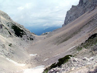
The trail from the Prielschutzhaus refuge to the Pühringer hut runs entirely along high-alpine terrain. At approx. 1,900m above sea level, below the 2,216m high Rotgschirr, cross the border between Upper Austria and Styria. Bearing in mind the karstic nature of this plateau, you should already be thinking about taking enough water supplies with you in Hinterstoder.
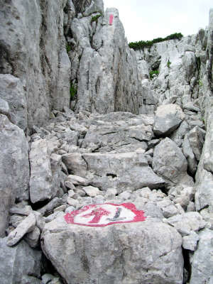
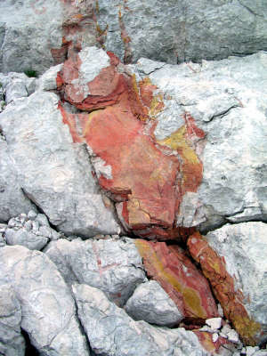
The first climb after leaving the refuge is still very steep. Follow the signposting for the Pühringer Hut, and the path will turn right to the Großer Priel mountain, with the track leading along the sloping ridge on an almost even course. Just below the entrance to the Klinserschlucht ravine between Spitzmauer on the left and Brotfall to the right, the trail becomes steeper and winds uphill in tight bends. The distinctive entrance to the ravine can, incidentally, even be seen from the valley floor. Even in the warm summer months, you will repeatedly come across remaining snowfields in this part of the Tote Gebirge mountain range, but they are not steep and are therefore easy to cross. The trail through the Klinser Schlucht ravine climbs steadily and, here at the latest, you will feel grateful to the trail builder for his good work, as even in good weather you will mostly be dependent on the red-white-red marks, as footprints cannot be seen on the stone trail. (In snow, it is only possible to use this trail with great difficulty, as the marks are not visible!) The Tremlbergsattel pass is reached after an approx. one-hour walk through the ravine (approx. 2h 45min from the Prielschutzhaus refuge). The route from the Tremlbergsattel is initially mainly downhill. It leads to the Ausseer Weg trail, coming from the Welser Hut. Follow the trail uphill again, whereupon red ore deposits can be seen every so often in the stones. The Rotkogelsattel pass is reached on a partly rather laborious route over large boulders and isolated snowfields. Here, a wonderful view over the western Tote Gebirge can be enjoyed, which is considerably greener than the middle section (approx. 2h from the Tremlbergsattel pass). There is a steep descent from the pass. The pines can help you on the descent along the smooth stone surfaces. You will reach a narrow passage that is clearly marked as such and jokingly bears the traffic sign "Give way to traffic from the opposite direction". After this steep climb, there is a leisurely, almost flat walk to the Pühringer Hut in the lovely setting of the Elmsee lake (approx. 1h 10min from the Rotkogelsattel). (Christina Schwann, OeAV)
Natural and cultural heritage
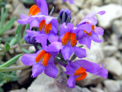
While the eastern foothills of the Tote Gebirge (“dead mountains”) around the Warscheneck are still quite green, the middle section around the Große Priel, the Spitzmauer and the Klinserschlucht ravine rather deserves this name. This section – with a surface area of 20km² the largest karstic plateau in the northern Limestone Alps – is to a large extent free of any vegetation and extremely short of water. It displays numerous typical karst formations such as dolines, shafts, gullies and caves. The Gaßel-Tropfsteinhöhle cave, the Bärenhöhle cave near the Salzöfen (salt cave) or the little Eishöhle (ice cave) at the Schönberg are particularly worth mentioning. The Gaßel-Tropfsteinhöhle can be reached from Ebensee. Although the entrance to this cave was already known for a long time to foresters and hunters, explorations into it only started in 1918, as a deep abyss is located just behind the entrance. The first time it was entered, the "Olymp" was reached and the second time the "Große Abgrund" in the "Kanzelhalle". With a depth of around 90m, it was a great challenge at the time to go down to the Große Abgrund and was only achieved in 1924 within the framework of an expedition with eight participants and 30 carriers. The Leopoldstrom, the biggest space in the cave, was discovered as well as the Wasserhalle (water hall), "Pollanschützgang" passage and the "Kleine Tropfsteinhöhle" cave – parts of the cave that match those open today in terms of beauty and fascination. So far, these parts have nevertheless remained closed due to major technical difficulties. Most of the cave, however, can be visited in the summer months. As the temperature in the cave is only approx. 6.5°C and is hardly subject to any yearly fluctuations, warm clothing is always advisable. In spite of the scarcity of water, there are still remarkable plants living in this austere part of the Tote Gebirge range that have adapted perfectly to the harsh climate. Examples of this limestone flora are the widely dispersed twoflower violet (viola biflora) and the magnificent alpine toadflax (Linaria alpina), which in the Limestone Alps is relatively common. The further the trail heads in the direction of the Pühringer Hut, the greener the high plateau becomes. More and more mountain pines cover the bare rocks and just before the hut, the trail crosses meadows with rich vegetation, including the monkshood (aconitum napellus) and the dwarf valerian (valeriana montana). (Christina Schwann, OeAV)
Other long-distance trails and alternative routes
Ascent of the Rotgschirr (2,261m) from the Pühringer Hut in 3h. Hochkogel (2,094m) from the Pühringer Hut in 1h; outer trail; north alpine trail 01
Useful topographic maps
15/2, Totes Gebirge, Mitte ~ Oesterreichischer Alpenverein (1:25.000)
ÖK 50 97, 3212 ~ Bundesamt für Eich- und Vermessungswesen (1:50.000)
WK 082, Totes Gebirge ~ Freytag&Berndt (1:50.000)
Nr. 19 Almtal, Steyrtal, Totes Gebirge ~ Kompass (1:50.000)
Favourites, criticisms ? Make your personal comments on this stage. For more general notes please use the comments section of the page Over to the Via Alpinists.
bergziege - 2012-09-10
Es gab sehr viele Schneefelder Juli 2012. Man muss nicht nur auf die Markierungen achten sondern auch auf Steinmandel, da manchmal auch die Markierungen nicht mehr vorhanden waren
Automatic translation
[Google]
There were many snowfields July 2012. One must not only respect but also markings on stone almond because sometimes the marks were no longer available

 |
6h00 |
14 km
|
704 m
|
503 m
|
6h00 |
14 km
|
704 m
|
503 m


Favourites, criticisms ? Make your personal comments on this stage. For more general notes please use the comments section of the page Over to the Via Alpinists.