Hiking (mountain trail, in places narrow and exposed)
Alpine route (equipped or very exposed section, snow field, blocks)
R97
Mund » Gampel / Steg
|
9h55 |
26.9 km
|
645 m
|
1200 m
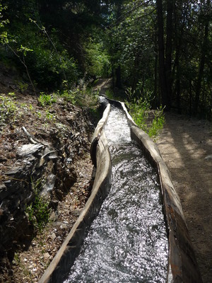
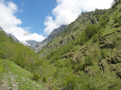
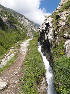
From Mund, head on a gentle descent down the valley to Eggerberg. Here, climb for a short distance to follow the "Gorperi-Suone" (open water channel). At its source in the Baltschiedertal, change to the "Niwärch-Suone" water channel and follow it to Niwärch. From Ausserberg, the high-altitude trail leads along the south ramp of the Lötschberg railway past Hohtenn to the destination at Gampel/Steg.
Easier alternative route
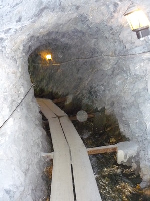
Niwärch water channel: alternatively, the tunnel can be used. But you will need a torch for this!
Leave Mund in a westward direction. Pass Färchu, a hamlet with a little chapel and continue along the farmland path to Ober Birch. Just before this lies one of the numerous herb gardens that line the trail on this stage. Here, leave the meadows and pastureland behind and walk down through the wood to the hamlet of Brand and on to Eggen. The trail leads alongside the Gorperi suone (historical water channel) into the Baltschiedertal valley, which contains many suones. On the other side of the valley, walk alongside the Niwärch suone, which due to the dizzying precipice requires you to be particularly careful and also inspires respect and admiration for the bold suone structures. For those who do suffer from vertigo, a torch is necessary, as the alternative involves a 1.6km-long, unlit tunnel, which it takes around 20min to walk through. Having passed the dizzying precipice or the tunnel, continue high above the Wallis valley floor winding your way alongside the Niwärch suone in the direction of Niwärch, from where a descent to Ausserberg starts. From here, the route continues on the ridge trail along the southern section of the Lötschbergbahn cable car. This hiking trail is very popular as it leads past rushing mountain streams that flow into the plunging side valleys and past imposing viaducts of the Lötschbergbahn cable car, which in themselves are a piece of railway history. Not only this, but also many extraordinary steppe grasses and other plants that thrive in dry conditions attract many people to hike in the unique, sunny location of the Rhonetal valley. Next, at the Hohtenn railway, walk down to the village of Hohtenn and then to Gampel/Steg, which lies on the Rhonetal valley floor. (Schweizer Wanderwege).
Natural and cultural heritage
“Suone” water channels Even 1,000 years ago, the inhabitants of the Wallis region were diverting the melted ice and mountain water from the streams using wooden channels and narrow water canals, the so-called “Suone” channels, to their meadows and arable land, as the people in the Wallis region have always suffered from drought. Many “Suone” channels along the steep slopes are stabilised with planted banks. However, on the steep rock walls, great wooden hooks were first of all anchored in the rock, into which “Chänla”, i.e. channels carved out of logs, were lodged. This work was very risky and many young men lost their lives in the process. The precious water was not freely available, and so entitlements indicating the corresponding water ration had to be distributed exactly and recorded in official documents. Such documents date far back to the 14th century, when a system of notches was used, which were carved on pieces of wood, so-called “Tasseln”. The irrigation duration of a water entitlement lasted from 2 to 3 weeks. Today, water for irrigating the meadows in the Wallis region is still much sought-after, but people have also found the means and methods to capture and channel it safely. Many “Suone” water channels have now been laid in pipes or even in tunnels, such as the Niwärch Suone of Ausserberg, which in especially exposed places today leads through a 1,680 metre-long, accessible tunnel. In many places, the irrigation system has now been replaced by sprinkler irrigation systems. (Schweizer Wanderwege)
Useful topographic maps
274T Visp ~ Swisstopo (1: 50'000)
Lötschental Lauchernalp 3-259-00327-4 ~ Hallwag Kümmerly und Frey AG, Urtenen BE (1: 25'000)
Aletsch Goms Brig Simplon ~ Hallwag Kümmerly und Frey AG, Urtenen BE (1: 60'000)
Useful guidebooks
Brig Simplon Aletsch Goms / Chrisitan Fux ~ Rotten Verlag AG Philipp Mengis (ISBN 3-907624-52-1)
20 Bergwanderungen Region Wallis / Luc Hagmann, Franz u. Brigitte Auf der Maur ~ Tamedia AG Werd Verlag (ISBN 3-85932-305-9)
Oberwallis / Waeber/Steinbichler ~ Bergverlag Rudolf Rother GmbH (ISBN 3-7633-4127-7)
Picture gallery
Add your own pictures!
Comments
Favourites, criticisms ? Make your personal comments on this stage. For more general notes please use the comments section of the page Over to the Via Alpinists.
Pascal - 2024-09-08
A Rarnerchumma, 2 chemins possibles en direction de Riedgarto-Ausserberg : par le Bietschal (cf. itinéraire décrit dans le topo), OU par le tracé de l'ancien chemin de fer de chantier et le pont ferroviaire du Bietschal (raccourci, sans montée, 30 minutes de moins. Avec un peu de chance, on peut croiser le train sur le pont !)
Berta - 2018-07-08
In Ausserberg gibt es die Möglichkeit einer Übernachtungen: Hotel Bahnhof , Zimmer mit Frühstück: 147 CHF
Automatic translation
[Google]
In Ausserberg there is the possibility of an overnight stay: Hotel Bahnhof, room with breakfast: 147 CHF
nspangler - 2016-07-28
Hiked into Gampel-Steg on a Saturday night in July 2016 to find no open hotels and only one restaurant serving dinner. Locals not very friendly. Advise skipping or passing through.
Clemens - 2015-07-08
Zum Kommentar von Elisabeht: Das ist wahr. Quert man den Bach und denkt jetzt geht es wieder links herum, muss man aber rechts laufen ins Tal hinein für ca. 5-10 Minuten. Man sieht einen tollen Wasserfall, und kommt zu Hütten und einer weiteren Brücke. Man geht aber nun links hoch zu den linken Hütten und trifft auf die Niwärch-Suone
Automatic translation
[Google]
To comment on Elisabeht: That's true. You cross the stream and now thinks it goes left again around, but you have to run right into the valley for about 5-10 minutes. We see a great waterfall, and comes to huts and another bridge. However, it is now left up to the left and strikes the huts Niwärch-Bisse
Clemens - 2015-07-08
Achtung: Der Weg ist aus Ausserberg hinaus am Bahnhof schlecht ausgeschildert. Man läuft schnell Richtung St. German also nach unten, man muss aber rechts bei den Bahngleisen hoch.
Automatic translation
[Google]
Caution: The road is from Ausserberg addition at the station poorly signposted. One runs quickly toward St. German so down, but you have to turn right up at the train tracks.
Elisabeth - 2014-12-05
Hélas, au fond de Blatschiedertal, il n'y a aucune indication pour le bisse Niwärch ! J'ai suivi le bisse Undra qui est aussi un bisse historique.
Automatic translation
[Google]
Alas, at the bottom of Blatschiedertal, there is no indication for Bisse Niwärch! I followed the Undra Bisse is also a historical Bisse.
Martine - 2014-09-01
Steg/Gampel - Il semblerait que le seul hébergement possible soit l'hôtel du Pont et il n'y a personne sur place. Porte fermée et un numéro de téléphone à appeler.
Automatic translation
[Google]
Steg / Gampel - It seems that the only possible accommodation is the Hotel du Pont and there's nobody there. Closed door and a phone number to call.
SPYD - 2012-09-23
Dénivelé erroné... Nous avons eu +510m et -1010m !
Les suonen valent vraiment le détour.
Plutôt que d'aller jusqu'à Naturbrücke, nous avons coupé par le pont de chemin de fer.
Aprés Brägji, nous avons suivi l'indication du pont suspendu, trés jolie descente dans la gorge et nous avons continué jusqu'à Hohten par Lüogjiu.
A Steg, trés bon accueil à l'hotel du Pont (+41279321129 - info@hotel-dupont.ch)
Automatic translation
[Google]
Elevation wrong ... We had 510 m and 1010m! The Suonen truly worth. Rather than going up Naturbrücke, we cut through the bridge rail. After Brägji, we followed the indication of suspended very pretty descent into the gorge and we continued to Hohten by Lüogjiu bridge. A Steg, very welcome at the hotel du Pont ( 41279321129 - info@hotel-dupont.ch)
Daniel - 2010-10-17
The 1.5km long watertunnel with footpath cuts off a very fantastic part of the route. Steep slopes along a at parts very narrow path along the Suonen (water-canals). Beautiful views. I saw some mountain-goats here. Imagine the amount of labor those 14th century mountain people had to do and the dangers they had to face, just to bring water to their village.
Daniel - 2010-10-17
In Aussenberg near the train station there is a hotel with dormitories. In the center of town at Pension Lötschberg there are some rooms for CHF 65.
Daniel - 2010-10-17
In Gampel the Hotel Garni du Rhone (CHF 68) has a very friendly warden who even knew about the Via Alpina!

 |
9h55 |
26.9 km
|
645 m
|
1200 m
|
9h55 |
26.9 km
|
645 m
|
1200 m


Favourites, criticisms ? Make your personal comments on this stage. For more general notes please use the comments section of the page Over to the Via Alpinists.