Hiking (mountain trail, in places narrow and exposed)
Alpine route (equipped or very exposed section, snow field, blocks)
A24
Trieben » Admont
|
3h25 |
11.7 km
|
441 m
|
509 m
The walk from Trieben to Admont over the Kaiserau is leisurely and not very long. The pass, which was already used many years ago to transport salt from Hall to the south, is now also being used by Via Alpina. The Nagelschmiede inn, managed today as it was then, invites you for a rest before continuing on into the national park village of Admont with its world famous monastery library.
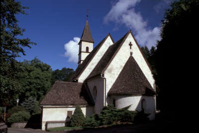
Until reaching the vicinity of Dietmannsdorf, Via Alpina follows the 08 trail on the main road and crosses the Murtal valley motorway. In Dietmannsdorf, keep to the right – past the beautiful little church and follow the street uphill, which soon opens onto a forest path. Follow this forest path without turning off it through the Obersonnberg area. After a short climb across meadowland, you will come to a roadway at the Hof Egger farm and reach a little chapel. The road leads gently downwards through the wood until coming onto the Kaiserau main federal road. Here, the path branches off to the Schloss Kaiserau castle, but this is private property and therefore cannot be visited. Take care not to miss the onward path to the Gasthof Nagelschmiede inn (approx. 2h). Immediately behind the inn on the left-hand side of the road, a track leads steadily somewhat downhill along the Lichtmeßbach stream. Finally, it comes across a forest path that again leads to the Kaiserau main road. This seldom used road soon brings you to the sign for Admont, which indicates the village to be not only a European community, but also a national park community. Walk at a leisurely pace through the Paradies area until coming directly into the centre of Admont (approx. 1h 25min from Gh. Nagelschmiede). A hiking trail branches off to the right of the road and leads along the Lichtmessbach stream up to the Gasthof Nagelschmiede inn. The trail to Trieben is well marked. (Christina Schwann, OeAV)
Natural and cultural heritage
Admont lies in a wide valley basin of the Ennstal valley. The market community in the Upper Styrian region has been a Europe community since 1977 due to its communal achievements and numerous European contacts. Since 1970, Admont has maintained a partnership with the Hessian town of Pohlheim in the Gießen district. Admont is also called the “Gate to the Gesäuse”, as it only lies a few kilometres further east of the start of the Gesäuse group. This area benefits from permanent protection with the Gesäuse national park. Furthermore, Admont can boast the most beautiful flower-covered mountain in Styria, the Grabenstein, and also the biggest monastery library in the world at the Admont monastery. The first settlers were presumably Celts. They opened up salt springs in Hall, dug for iron and copper ore and lived as hunters, fishermen and woodcutters. Christanisation took place after 600 A.D. In about 800 A.D., Arch Bishop Arn of Salzburg established the parish church, dedicated to St. Amandus. The first documentary evidence of the current name Admont goes back to the year 859. This wild area, at the time still part of Bavaria, was so fortified by the surrounding nature that it was ideal for the seclusion of the earlier Benedictine monastery. The rich but unhappy Hemma von Gurk donated the land to the Archbishopric of Salzburg, with the wish to set up a Benedictine monastery here. On the advice of a deaf mute, whose practically incomprehensible words were taken as a sign from God, the monastery was built on the south side and was thus sheltered from flooding and started in 1074 with 12 monks. Despite damage caused by fire on several occasions, the Benedictine monastery remained the spiritual cultural centre of the entire Ennstal valley and for centuries, even in present times, the development of the valley went hand in hand with the history of the monastery. Gesäuse national park is the sixth and most recent national park in Austria. The ceremonial signing of the State treaty and the subsequent foundation ceremony took place on 26 October 2002. But the process of establishing the national park was a long one. Although the entire Gesäuse region and parts of the northern foothills had already been declared as the first nature reserve in Styria in 1958, this legal situation allowed for the opening of an industrial plant and the zone shrunk to approx. 11,500ha. It was only when the Limestone Alps national park was introduced in 1997 that the discussions returned to the issue of the Gesäuse national park. An 11,300ha zone between Hieflau and the start of the Gesäuse region, the northern area of the Buchstein and the southern slopes of the Hochtor group now stands under this strict protection. Its special feature is the extraordinarily high number of natural habitats, created by the high relief energy and the related rich structural variety in a very narrow space. Visitors to this area will appreciate the stillness along the hiking trails, the dreamy spots by the Enns river and the flowering splendour of the meadows around the Sulzkarsee lake. (Christina Schwann, OeAV)
Other long-distance trails and alternative routes
Alternative from the Nagelschmiede inn past Kaiserau Castle to the Oberst-Klinke-Hut and over the Riffelgrat ridge and Kreuzkogel group to Kematen and Admont. Trail no. 601, high-altitude variation, only suitable in good weather and only for experienced mountaineers. You are advised to stay overnight at the Oberst-Klinke-Hut. Nordalpenweg trail 01, Eisenwurzenweg trail 08
Favourites, criticisms ? Make your personal comments on this stage. For more general notes please use the comments section of the page Over to the Via Alpinists.
Mountain Girl - 2013-10-21
Ghf. Nagelschmiede appears permanently closed (as of June 2013). Trail markings also very poor to get here.

 |
3h25 |
11.7 km
|
441 m
|
509 m
|
3h25 |
11.7 km
|
441 m
|
509 m


Favourites, criticisms ? Make your personal comments on this stage. For more general notes please use the comments section of the page Over to the Via Alpinists.