Hiking (mountain trail, in places narrow and exposed)
Alpine route (equipped or very exposed section, snow field, blocks)
R49
Weißenbach am Lech » Prinz-Luitpold-Haus
Trail crossing
|
8h30 |
26.8 km
|
1429 m
|
474 m
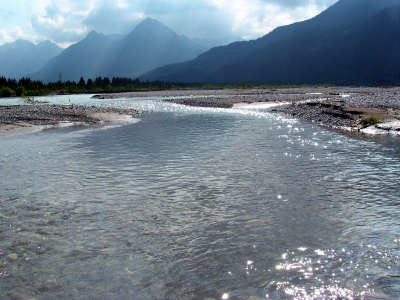
This stage is dominated by the Lechtal valley in Tyrol, the last great wild river landscape in Europe, a Natura 2000 site and a future nature park. Leave the vast gravel banks of the River Lech behind and follow the course of the Schwarzwassertal valley through picturesque flood-plain woods, to the door of the Allgäu mountain world, where the Hochvogel sits in majestic splendour above all the other peaks.
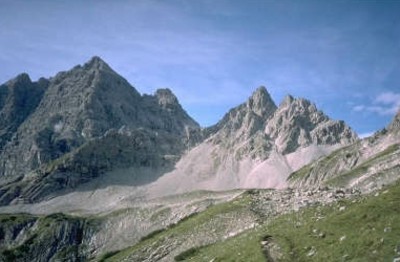
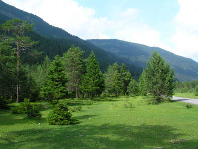
In Weißenbach, follow the road past the church and post office and keep to the left, following the cycle path signs. The main road crosses this path and takes a turn to the right at the open-air pool. After a short stretch along a narrow gravel path, you will reach the actual cycle path and follow it along the bank of the Lech. Between the trees, it is possible now and again to have a view over the romantically wild river landscape, the turquoise water and the white gravel banks. At a fork in the road, you can take a detour to the Baggersee lake, a favourite excursion destination for locals and guests alike and very suitable for bathing in summer. Just before the "Johannesbrücke" bridge, follow the signs for "Vorderhornbach". Cross the bridge and thus the main road, keeping to the right. An interesting illustrated chart complements the wonderful view over the Lech, explaining all there is to know about this unique landscape and Natura 2000 site. Follow the gravel path to reach the narrow asphalt road, which you must follow to the left further into the valley. Another interesting vantage point is the suspension bridge to Forchach. The small detour down to the bridge is by all means worth while. Continue along the cycle path, shortly afterwards reaching the "Geisterstein" (or ghost rock) and a little well. The path leads to the lovely Radsperrboden meadowland, which is almost park-like in character and is crossed by numerous watercourses. You will soon reach the hunting lodge, finally crossing the bridge over the Scharzwasserbach stream. Immediately afterwards, the forest road into the Schwarzwassertal valley branches off to the right. There is then a gentle incline up through this completely unpopulated and densely wooded valley until reaching the Jagdhüttenalm meadow. Follow the trail here through the Saldeiner wood and cross the northern slope of the wild Roßzahn group, crossing the Schwarzwasserbach stream just before the Eibles Hut (3h 40min). A narrow, signposted path starts at the end of the forest road at the Fuchswald hunting lodge, which leads to the Oberen Lichtalpe meadowland. Follow the track further uphill until coming to a path crossing the slope, which must be followed to the right. Pass the Bergwachthütte refuge to reach the "Jubiläumsweg" trail and thereby also the Purple Trail of Via Alpina. Together, the Red and Purple Trails lead to the left between the Glasfelderkopf and Kesselspitze peaks steeply upward to the Bockkarscharte wind gap. On the other side of the wind gap, the track leads less steeply downward to the Prinz-Luitpold-Haus lodge (4h 30min from the Eibles Hut). (Christina Schwann, OeAV)
Natural and cultural heritage
The extensive, sparsely populated area of gravel beds along the Lech river is not the result of a "degenerated river", nor is it either hostile or useless, but rather the work of well functioning river dynamics. Numerous animal and plant species depend on these dynamics, including the German tamarisk and the little ringed plover. The little bird broods on the gravel and searches for its food in the littoral drift. Overgrown areas as breeding grounds are out of the question for it. On the trail from Weißenbach to the Johannesbrücke bridge, it is possible to admire the junipers up to 10m in size, which do not occur in this form anywhere else in Tyrol. There have been efforts since 1970 to place parts of the Lech with its water meadows under nature protection. Numerous attempts by the “Verein für Heimatschutz and Heimatpflege in Tirol" (association for heritage protection and maintenance in Tyrol) did however not succeed because of the great interest shown by energy companies. Reutte electricity works planned a dozen new power stations, the first at the Streimbach stream, a Lech distributary, which is classified by specialists as unique above all due to its numerous gravel islands and troughs where rush skeletonweed, alpine butterbur and hoary willow grow and the stable areas with a pine forest rich in species. These power stations would not only have robbed the Lech of its boulder supply, but the populations living on its banks would finally have been wiped out by the water torrents rising up several times a day. The interception of large volumes of water would have prevented the gravel bed areas from being flooded, which would have caused the land to become overgrown and thus displaced the animal and plant species dependent on these areas. The people of Tyrol mounted opposition to the planned power station just on time und the idea of a national park began to take form. While the discussion on the national park continued, the Lech river was registered with the European Union as a Natura 2000 site, which was in any case already a step in the right direction. A national park would however also be of major interest from a touristic angle for the little known Außerfern region. Unfortunately, nothing came of it. The mayors of the Lechtal valley voted against the national park and in favour of the Wild River Landscape of the Tyrolean Lech nature park, which is continued in the High Alps of the Allgäu nature reserve. This was ordered on 24.01.1992 by the government of Swabia in a bid “to protect the outstanding beauty, diversity, uniqueness and tranquillity in its entirety" (extract from the decree). Human interventions in the form of the construction of new trails, buildings or lifts and ski slopes are thus prohibited. The natural potential is to be maintained and protected for future generations. (Christina Schwann, OeAV)
ÖK 50 115, 114 ~ Bundesamt f. Eich- u. Vermessungswesen (1:50.000)
Picture gallery
Add your own pictures!
Comments
Favourites, criticisms ? Make your personal comments on this stage. For more general notes please use the comments section of the page Over to the Via Alpinists.
Thorsten - 2022-09-13
On the route to Forchach we recommend not staying on the bicicle road. Instead, right after the Lechsteg (near the public swimming pool), take the small footpath to the left, which is very quiet and right by the Lech, and passes some interesting private leisure huts that are open to the public!
We can confirm what Piet Clerinx wrote about the path above the Obere Lichtalpe. It is not really visible any more, so we too had to use the GPS track.
Piet Clerinx - 2022-08-04
Between the Obere LichtAlpe and the path crossing the slope at about 1800m there is no track anymore, let alone way markings or signposts. You have to search your way up. Luckily I had the gpx of this route downloaded on my smartphone, so I knew where they trail was supposed to be.
POPEYE GG - 2019-02-03
Mardi 26 juin 2018
Longue étape avec grande marche d'approche le long du Lech. La deuxième moitié de la montée est plus difficile, d'autant qu'il y a encore de la neige avant d'arriver à la Bockkarscharte, où nous avons pu admirer des chamois.
Automatic translation
[Google]
Tuesday, June 26, 2018 Long stage with great walk along the Lech. The second half of the climb is more difficult, especially since there is still snow before arriving at the Bockkarscharte, where we could admire chamois.
Martin - 2018-08-15
Die Warnung von Tentorini Chantal muss man nicht berücksichtigen, da man sich am Trinkasserbrunnen auf der Terasse des Prinz-Luitpold-Hauses jederzeit kostenlos Wasser abfüllen kann.
Bei schwierigen Wetterverhältnissen erhielten wir kompetente Informationen zum Wetter und Weg vom Hüttenpersonal.
Automatic translation
[Google]
The warning of Tentorini Chantal you do not have to take into account, because you can at the Trinkasserbrunnen on the terrace of the Prinz-Luitpold-house at any time free water to fill. In difficult weather conditions we got competent information about the weather and the way from the hut staff.
I hiked via Brocksee and Landsberger Hütte, probably on the purple trail (?). Beautiful panorama route, a few small "climbs," with steel cables, very good views. Not much water though.
The track to the Bockkarscharte is hard to find. Grass has overgrown it, and cows made their own alternative tracks. But the GPS track is quite good here, use it and you will be OK. Watch the memorial on the Scharte, erected for an officer in 1939; with a nazi symbol still clearly visible.
Tentorini Chantal - 2015-09-25
Attention, le verre d'eau du robinet est facturée à 2,50 € au refuge Prinz Luitpold. Voilà un prix bien royal pour un verre d'eau!!!
Automatic translation
[Google]
Warning, the glass of tap water is charged at € 2.50 at the shelter Prinz Luitpold. This is a very royal price for a glass of water !!!
Michael - 2013-08-21
If you are walking from Prinz Luitpold Haus to Weissenbach be aware that the point where the red trail leaves the purple trail is not signposted. To find it, look for a rock with the letters "P.L.H." and an arrow pointing the way you came. That is to tell walkers going the other way where Prinz Luitpold Haus is. The trail is not clear on the ground but you should soon see red marks on rocks identifying it.
Elisabeth - 2012-12-29
Je confirme : le sentier est très mal indiqué dès le début, même si, de loin en loin, on voit un signe de la Via Alpina. Cela empire après la dernière barrière. La première mention du refuge Prinz Luitpold se trouve au niveau de Bergwarchthütte (!) et encore il s'agit d'un poteau cassé posé par terre dont l'écriteau aurait dû se trouver à la jonction avec le sentier Jubiläumsweg !
Automatic translation
[Google]
I confirm: the trail is very poorly marked from the beginning, even though from time, we see a sign of the Via Alpina. It gets worse after the last barrier. The first mention of refuge Prinz Luitpold is located at Bergwarchthütte (!) And yet it is a broken pole lying on the ground that the notice should have been at the junction with the trail Jubiläumsweg!
Alpinisten - 2012-09-24
Der Weg ab der Oberen Lichtalpe Richtung Prinz-Luitpold-Haus ist schlecht markiert. Für diese Etappe in Weißenbach gut mit Proviant eindecken, unterwegs keine Einkehrmöglichkeit.
Automatic translation
[Google]
The path from the upper light Alpe direction Prinz Luitpold house is poorly marked. For this stage in Weissbach well stock up on supplies, road no refreshments available.
Margy - 2012-02-07
25/6/11 Long hike to Prinz-Luitpoldhaus...the final pass in protected by cables and steps. The hut is very well organized and very crowded. Many gemsen near the pass.
Ulrich Aellig - 2009-07-14
Was sollen denn die blauen Dreiecke (Gipfel)? Es sieht jan ein blinder mit dem Stock vom Schiff aus, dass es sich nicht um Gipfel handeln kann.
Automatic translation
[Google]
What then are the blue triangles (top)? It looks jan a blind with a stick from the ship, that it can not act to top.

 |
8h30 |
26.8 km
|
1429 m
|
474 m
|
8h30 |
26.8 km
|
1429 m
|
474 m


Favourites, criticisms ? Make your personal comments on this stage. For more general notes please use the comments section of the page Over to the Via Alpinists.