Hiking (mountain trail, in places narrow and exposed)
Alpine route (equipped or very exposed section, snow field, blocks)
R46
Reintalanger Hütte » Coburger Hütte
|
6h00 |
17.3 km
|
1173 m
|
668 m
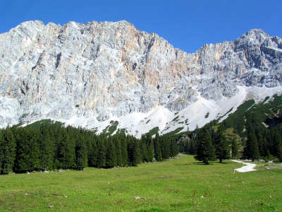
A beautiful stage full of great contrasts lies ahead. It starts off on an uphill course to the threshold of the barren Zugspitzplatte plateau, where you must cross the Gatterl gap over to the Austrian side of the border. Below the impressive Wetterwand ridge, walk over meadows to the Sebensee lake and the Coburger Hut.
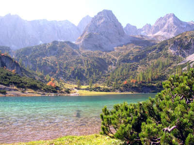
From the Reintalanger Hut to the Knorr Hut, Via Alpina still follows trail 801, the North Alpine Trail, which then continues at the Knorr Hut further to the North West to the Münchner Haus lodge. From the refuge, start off still on an almost flat course across the sheep pasture to the Obere Anger. Then, however, it gets steeper. The trail winds its way upward in sharp bends, turning to the North and heads for the Brunntalkopf peak. At the fork in the road, take the right-hand trail with the sign "Felsensteig" (rocky track) leading upward across boulder-strewn terrain. The left-hand trail heads to the "Veitlbrünndl" and bears the sign "Muliweg", which also leads to the Knorr Hut. After a steep climb of approx. 2h, you will reach the Knorr Hut of the Munich DAV (German Alpine Club) Section, which like the Reintalanger Hut is a designated “non-smoking refuge”. At the refuge, Via Alpina now leaves the Nordalpenweg (north alpine trail) and keeps directly to the South. The trail leads along the "Plattsteig" track on an almost flat course over the barren Zugpsitzplatt plateau. Only at the end does the trail head down a little until reaching the "Gatterl" ski run (local word for “little gate”), the border between Germany and Austria (approx. 45min from the Knorr Hut). From the Gatterl, head upward through rocks again to the Feldernjöchl pass at 2,045m. At the fork in the road, keep to the right in the direction of "Hochfeldernalm, Pestkapelle". Moving out of the cirque, the trail heads below the Gatterlköpfe and the Plattspitzen peaks down onto greener land. Leave the precipitous and desolate rocks behind you and continue straight ahead towards the South at the fork in the road, until reaching the Hochfeldernalm meadow, where you must turn left on the track through mixed mountain forest down to the “Pestkapelle”, Chapel of the Black Death, (approx. 1h 15min from the Gatterl). Here, cross the Geißbach stream and follow the track through the wood up to the road, which must be followed to the left. At the crossroads, continue straight ahead in the direction of the "Seebenalm" meadow. Follow the road, with a track branching off on the left to the Iglsee lake, then take a forest road that comes to a dead end. At the next fork in the road, keep to the left and follow the trail on an almost level course through the wood to the Seebenalm meadow (accommodation facilities) and to the picturesque Seebensee lake with a glorious view over the Wetterwand peak (approx. 1h from the Pestkapelle chapel). The trail continues on an even course a little further, although it then becomes steep again and – to the right at the fork in the road – heads upward in many sharp bends to the Coburger Hut above the Drachensee lake. (Christina Schwann, OeAV)
Natural and cultural heritage
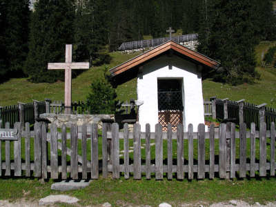
This very long stage leads over the impressive Zugspitzplatt plateau. This western section of the Wettestein mountains is bordered in the south by the Gatterl, an easy pass crossing. Via Alpina also runs just above this Gatterl, leading downhill to the Pestkapelle (chapel of the plague). The construction of the little chapel dates back to a solemn pledge in the year 1634, when the plague was claiming a great many victims. Below the mighty Wetterwand face, walk over the beautiful Ehrwalder Alm meadowland to the Seebenalm meadow, just before which a wonderful view into the valley basin with the typical Tyrolean town of Ehrwald can be enjoyed. The wide valley basin is above all charming due to its distinctive Moos nature reserve, a vast reedy landscape on the valley floor. Farmers already used this area long ago as grazing ground for cattle, and for harvesting hay and cereals. About 400 years ago, a project idea was suddenly developed, which people still clearly remember today. In 1577, the sovereign Archduke Ferdinand II decided to convert the Moos area into a lake again, in emulation of Duke Siegmunds and Siegmundsburg, his pleasure castle, and to build a castle in the middle on the so-called Duhme-Bühel island. The area was to be flooded with the help of a dam close to today’s train station. The farmers of Ehrwald, Lehrmoos and Biberwier sent a desperate petition to the sovereign ruler, for without the Moos they would not be able to survive. Furthermore, they pointed out that such a large area of water would bring a lot of mist and frost with it and change the climate for good. Whether it was due to financial reasons, the petition from the population or even a request from his wife, we don’t know. But Archduke Ferdinand II abandoned the hare-brained plan at the last minute. Close to this vantage point, the trail changes from the Wetterstein to the Mieminger chain. The Drachenkopf peak over the Seebensee lake and the Coburger Hut at the Drachensee lake are displayed from a very impressive angle here. Both lakes are crystal clear and surrounded by wonderful vegetation of larches, pine and the rowan trees with their striking red tones in autumn. The mountain range of the northern Limestone Alps is bordered by the Oberinntal valley in the south, the Fern pass in the west, the Gaistal valley in the north and the Seefelder Sattel pass in the east. The highest summits are the Hochplattig at 2,768m and the Hohe Munde at 2,662m in altitude. (Christina Schwann, OeAV)
Favourites, criticisms ? Make your personal comments on this stage. For more general notes please use the comments section of the page Over to the Via Alpinists.
POPEYE GG - 2019-02-03
Samedi 23 juin 2018
Magnifique étape, malheureusement les nuages s'accrochent à la Zugspitze, ne la dégageant pas complètement.
Comme déjà signalé, il ne faut pas compter sur une place à la Coburger Hütte, aussi nous poussons jusqu'à la Biberwiererscharte, d'où nous "plongeons" (descente assez raide dans les éboulis) jusqu'à Bieberwier où nous occuperons la dernière chambre disponible au sympathique hôtel Regina.
Le soir, nous avons pu y admirer des traditionnels feux de la Saint-Jean dans la montagne, dont un justement allumé dans la Biberwiererscharte.
Automatic translation
[Google]
Saturday, June 23, 2018 Beautiful stage, unfortunately the clouds cling to the Zugspitze, not releasing it completely. As already mentioned, do not count on a place at the Coburger Hütte, so we push to the Biberwiererscharte, where we "dive" (steep descent in the scree) to Bieberwier where we will occupy the last room available at the friendly Regina hotel. In the evening, we were able to admire the traditional fires of St. John in the mountains, including a fair in the Biberwiererscharte.
SPYD - 2017-08-11
Malgré la fin de nuit rude (je rejoins l'avis de Daniel) c'est une superbe étape. Pause café à KnorrHutte puis picnic à Hochfeldernalm. Pause à Seebenalm (pour laisser passer l'orage). Très bonne ambiance et confort à CoburgerHutte.
Automatic translation
[Google]
Despite the late night hard (I agree with Daniel) it's a great step. Coffee break at KnorrHutte then picnic at Hochfeldernalm. Break in Seebenalm (to let the storm pass). Great atmosphere and comfort at CoburgerHutte.
Biberwier Camping Mariencamp is super, 10,- for a night, friendly staff and great showers. In Biberwier is a supermarket, open from 7.30 until 18.30. The path through the forest between Biberwier and Biberwier Scharte is well marked now.
Horrible night at the Reintalanger Hut, which was packed full with Zugspitze climbers. I heard the same about the next Coburger Hut (long holiday weekend in Germany). So I inquired at the Hochfelder Alm, and it turned out that since 3 weeks they had accommodation. Three very luxurious multi-bed rooms, showers, WLAN, all. €48 HP, dinner a la carte, and wine included. Very well recommended.
Margy - 2012-02-07
22/6/11 Yesterday we climbed the Zugspitze from Knorrhutte--worth the climb just to see all the mobs at the top. Many gemsen on the trail to Seebeealm where we ate good studel. The climb to Coburger Hut is steep, and after a break here we continued over the Biberwierer Scharte wind gap to Lermoos.
Janek - 2011-07-21
From Knorrhütte it's only few hours to the Zugspitze. One has to ascend about 600 meters to reach the ski lifts and from there it's possible to take the cable car to the top or ascend another 300m on foot. Of this last 300 the first 100m or so are not very easy 'cause it's rather steep and covered in loose scree, but it's still manageable. Highly recommended although the top itself is festered with restaurants and stuff like that. Cool museum though.

 |
6h00 |
17.3 km
|
1173 m
|
668 m
|
6h00 |
17.3 km
|
1173 m
|
668 m


Favourites, criticisms ? Make your personal comments on this stage. For more general notes please use the comments section of the page Over to the Via Alpinists.