Hiking (mountain trail, in places narrow and exposed)
Alpine route (equipped or very exposed section, snow field, blocks)
R37
Ginzling » Finkenberg
|
2h15 |
9.6 km
|
204 m
|
355 m
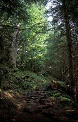
A leisurely hike from Ginzling across the meadows on the valley floor of the Zemmtal valley outwards along the "Lass dir erzählen... von Karlsteg nach Breitlahner" theme trail (“Let us tell you...”), past the Gamsgrube snack-bar and Karlsteg inn. Continue on a narrow woodland path up to Finkenberg - Dornau. Here, the "Glocke" (“bell”) nature trail leads into a beech wood, which is a rarity in the Central Alps!
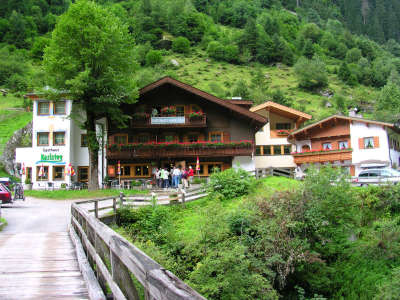
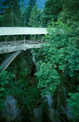
In Ginzling, walk past the church and the little grocery shop. Stay on the left-hand side of the stream, walking through the village of Dornauberg and soon arriving at a flat path that leads across the meadows. Follow it until Hof Strahnbach farmstead, where you must continue straight on along the road on a now upward course to the Gamsgrube inn. Continue the gentle climb to reach a fork in the road. While the trail turns off to the Gams Hut, Via Alpina follows the track straight on across the meadows. A gently undulating course finally takes you to the Karlsteg inn, which also marks the end of the “from Karlsteg to Breitlahner” theme trail in the "Lass dir erzählen!” nature park series (approx. 1h 15min). Cross the road from Ginzling to Mayrhofen and follow a track on the right-hand side over the avalanche defence structure into which the road disappears. On coming down again, cross the road and also the Zemmbach stream once more and follow a steep, sharply bending track uphill through the wood. The track soon becomes flatter, however, and a leisurely walk takes you through the mixed mountain woodland strewn with block stones to Finkenberg. In the village of Dornau, keep to the right and follow the “Glocke Rundwanderweg” hiking trail through beautiful surroundings for a while before arriving at the little graveyard, where the Tuxbach stream must be crossed to arrive directly in the centre of Finkenberg. Where the trail meets the road to Ginzling, cross immediately to the other side onto a track that leads over the tunnel in the road. It would be too dangerous to take the road into the tunnel. (Gudrun Wallentin, Christina Schwann, High Alpine Zillertal Alps Nature Park, OeAV)
Natural and cultural heritage
In the middle of the 19th century, the Zillertal valley became a new discovery for mountain tourism. The first mountain guides were not in fact official guides but rather farmers from the valleys who were thoroughly familiar with the mountains around them. One of them was Georg Samer, and his name was known far beyond the Zillertal valley. He was not only one of the best mountain guides of his time – he also drew on the frequent occurrence of rare minerals that exist thanks to the central gneiss zone (crystalline inner core of the Tauern window). As a collector of minerals, he was able to boost his income and several of his samples can even be admired in the Natural History Museum in Vienna. In 1865, Paul Grohmann was the first man to climb the Hochfeiler, which at 3,510m is the highest mountain on the main Zillertal ridge. His guides were Georg Samer and Peter Fuchs. In 1884, F. Dych together with local Dornauberg inhabitant and first ever authorised mountain guide Hans Hörhager were the first to climb the 300-metre high and 60° steep ice wall, the "Hochfeiler-Nordwand". A total of far more than 20 first climbs are attributed to Hans Hörhager. Even in recent times, Ginzling is seen as the quintessential mountaineering village, even though the popularity of mountain climbing has somewhat diminished. And even today, it is the locals of Ginzling and Mayrhof who have attained world fame as mountain guides and climbers, such as Gerhard Hörhager, who founded the climber’s paradise "Die ewigen Jagdgründe" (the eternal hunting ground) on the trail from the Breilahner to the Kaserleralm meadow. He belongs to the world elite of top free climbers and is the leading figure of the sports climbing scene in the Zillertal valley. Peter Habeler, also born in Mayrhofen in 1942, is likewise a well-known mountain guide, who in 1978 climbed Mount Everest together with Reinhold Messner without oxygen, which at the time went against the accepted doctrine. (Christina Schwann, OeAV, Gudrun Wallentin, Zillertal Alps Nature Park)
Useful topographic maps
35/2 Zillertaler Alpen, Mitte und 35/1 Zillertaler Alpen, West ~ Oesterreichischer Alpenverein (1:25.000)
Favourites, criticisms ? Make your personal comments on this stage. For more general notes please use the comments section of the page Over to the Via Alpinists.
Carsten - 2022-01-10
Via Horribile Anti-Alpina
Highlight is the 150m climb to an electricity python before descending again to Finkenberg. Potable water faucet at fountain c.30m before supermarket Spar in Finkenberg. Supermarket is smaller than in Sexten but well-stocked.
Lolo - 2019-07-29
Pour info, si cela peut servir à d'autre randonneur, pour ne pas me perdre j'utilise l' appli Maps.me. Gratuite, fonctionne avec les satellites, pas besoin de reseau. Pratiquement tous les chemins de randos y sont. Il faut juste télécharger les cartes des lieux où lon se trouve. Elle marche dans tous les pays. Pas besoin d'acheter toutes les cartes de randos. Sert aussi de GPS voiture piétons train et vélo. J'ai chargé la trace de la Via Alpina avec les infos du site et plus aucun pb de direction. Seul pb elle consomme de la batterie...il faut juste l'utiliser pour verification et avoir une batterie externe.
Automatic translation
[Google]
FYI, if it can be used for other hikers, not to lose myself I use the app Maps.me. Free, works with satellites, no need for network. Almost all the hiking trails are there. Just download the maps of where you are. She walks in all countries. No need to buy all the hiking maps. Also serves as GPS car pedestrian train and bike. I loaded the track of the Via Alpina with the info of the site and no more pb of direction. Only pb it consumes the battery ... it should just be used for verification and have an external battery.
POPEYE GG - 2018-06-13
12 juillet 2017
35ème et dernière étape pour cette année.
Pas très intéressante, il faut bien l'avouer, car il y a des travaux sur le chemin. Le mieux aurait été que je suive la route pendant 4 à 5 kilomètres (à la sortie du pont env. 1 petit km après le Gastaus Karlsteg). Le chemin monte alors dans la forêt, et c'est ici plus sympa.
En arrivant, je suis allé directement sur Mayrhofen, en laissant Finkenberg de côté, pour rejoindre le joli train touristique de la Zillertal qui mène à la vallée d'Innsbruck.
A l'année prochaine!
Automatic translation
[Google]
July 12, 2017 35th and last stage for this year. Not very interesting, it must be admitted because there is work on the way. It would have been better if I followed the road for 4 to 5 kilometers (at the exit of the bridge about 1 km after Gastaus Karlsteg). The path then climbs into the forest, and it's more fun here. Arriving, I went directly to Mayrhofen, leaving Finkenberg aside, to join the pretty Zillertal tourist train that leads to the Innsbruck valley. See you next year!
The Ginzling hiking path to Gasthaus Karlstag is partly gone due to an avalanche, you have to hike the road. The supermarket in Ginzling is permanently closed. Several people told me that there's a campsite in Ginzling, well there is not, but apparently it happens often that hikers camp near the information centre. I asked around and got a nice place near the music theatre thingy.
Dorian - 2016-11-12
If the weather is nice and you want a less boring day with far better views: Ginzling -> Gamsgrube [Georg-Herholz-Weg] -> Gamshutte [lunch: Specknodelsuppe] -> [Hermann-Hecht-Weg] Finkeberg. It's about 1,000m up and down, perhaps 3 hours up and 2 hours down along very well constructed trails.
In Finkenberg, the Balthasarhof (nr 126) you will be welcomed with a schnapps. B&B €35pp. Recommended, I had dinner in nearby Hotel Eberl, where locals sang some beautiful authentic Jodl music.
berta - 2014-08-02
haben in finkenberg in der pension balthasarhof genächtigt. sehr angenehm, schöne große zimmer u gutes frühstück
Automatic translation
[Google]
have slept in finnish in the pension balthasarhof. very pleasant, nice big room and good breakfast
Elisabeth - 2012-12-24
Pas de ravitaillement à Ginzling mais il y a tout ce qu'il faut à Finkenberg.
Automatic translation
[Google]
No refueling Ginzling but there is everything you need to Finkenberg.
Jean-Louis GIRAUD - 2012-03-29
Etape déroutante s'il en est !
L'itinéraire est court, trés court ...Mais c'est aussi un moment de respiration pour observer le travail des hommes et la descente du foin dans des pentes impossibles au dessous d'immenses lignes electriques car plus haut les barrages turbinent ...eux aussi !
Pour autant je n'ai pas échappé à la pluie ...A FINKENBERG j'ai trouvé assez facilement un hotel :
HOTEL DORNAUHOF
Familie KROLL
308 DORNAU / 6292 FINKENBERG
Tel 00 43 (0)5285 62696
email: info@dornauhof.at
www.dornauhof.at
Trés bon accueil et grande cordialité des propriètaires fidèles à la réputation de l'Autriche.Prix correct et buffet impressionnant mème pour un Via Alpiniste !
Automatic translation
[Google]
Step confusing indeed!
The route is short, very short ... But it is also a moment of breathing to observe the work of men on and off the slopes impossible hay beneath huge power lines as above dams turbinent .. . too!
So far I have not escaped the rain ... A FINKENBERG I found a hotel quite easily:
Hotel Dornauhof
Familie KROLL
Dornau 308/6292 FINKENBERG
Tel 00 43 (0) 5285 62696
email: info@dornauhof.at
www.dornauhof.at
Very welcome and cordiality of the owners loyal to Austria's reputation. Correct and impressive buffet price for Via meme Mountaineer!

 |
2h15 |
9.6 km
|
204 m
|
355 m
|
2h15 |
9.6 km
|
204 m
|
355 m


Favourites, criticisms ? Make your personal comments on this stage. For more general notes please use the comments section of the page Over to the Via Alpinists.