Hiking (mountain trail, in places narrow and exposed)
Alpine route (equipped or very exposed section, snow field, blocks)
R36
Pfitscherjoch / Passo Vizze » Ginzling
|
5h40 |
24.6 km
|
86 m
|
1358 m
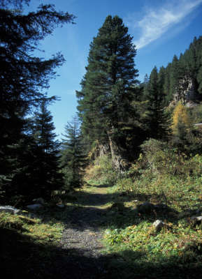
Coming from the Pfitscher Joch pass, walk through the lovely Zamser Grund valley to the Schlegeisstausee reservoir. The popular outing destination is usually very busy, but behind the retaining wall it gets more peaceful. Past Breitlahner, Via Alpina takes you along the “Lass dir erzählen” (“Let us tell you...”) discovery trail, which places many forgotten special features of the Zillertal valley into the limelight.
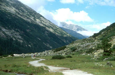
At the Pfitscherjoch pass, cross the Italian-Austrian border at 2,246m. The hiking trail leads downhill into the Zamser Grund valley. The Zamserbach stream and numerous little watercourses flowing down from the mountainsides wind their way along this almost flat valley floor and must be jumped over. A little chapel stands by the Zamsgatterl inn. A few cars park to the left of it, having driven up on the toll road to the Schlegeisstausee reservoir, which is a tourist attraction in summer months. Along the shore road, the Dominikus Hut soon comes into sight, located a little higher up on the left-hand side. At the last car park just before the tunnel, into which the road now disappears, the hiking trail leads downhill to the right towards Breitlahner, just behind the dam wall. The trail leads downward in sharp bends and the impressive dam wall rises overhead, casting you into its shadow. A pleasant hiking trail leads along a gentle downward route out of the valley. Where the trail meets the road, cross the road and continue on the other side to the right along the hiking trail. The track leads leftward up to the Friesenberghaus lodge and Olperer Hut. Continue along the meadowland path until you are above the toll house, after which there are still a few sharp bends through the wood to tackle before the road and then immediately after that the Alpengasthof Breitlahner alpine inn to the right come into view (3h 40min from the Pfitscherjoch-Haus lodge). The route from the Breitlahner inn to the Kaserleralm meadow must still be taken along the road, because no official trails exist on the eastern side of the stream. This could soon change however. After approx. 30min, a little road branches off to the left just after the Kaserleralm meadow. Follow it (not the uphill path on the left to the Birgelbergalm meadow) on a slightly undulating route. The Roßhag inn invites you to take a rest before coming out onto the broader road at the Roßhag power station. Keep heading to the left, however (not right over the bridge), before continuing on to Ginzling. In Ginzling, stay on the western side of the Zemmbach stream (do not cross the bridge) and pass the church, the multipurpose building and also the little hunting chapel. At the Kaserleralm meadow, stay on the road and follow it until reaching Breitlahner. The trail turns off uphill into the wood just behind the toll house. Follow it until the turnoff for the Friesenberghaus lodge, cross the road here and continue your walk on the other side. (Gudrun Wallentin, Christina Schwann, High Alpine Zillertal Alps Nature Park, OeAV)
Natural and cultural heritage
The Zillertal Alps Nature Park stretches over an area of 372km². Together with the Hohe Tauern National Park and the Nature Park Rieserferner-Ahrn of South Tyrol, these three nature reserves form the largest connected nature reserve area in the Alps. All three reserves pursue the same goals: 1. protection and exploration of the natural landscape, 2. information and environmental education, 3. encounter with nature and the countryside 4. sustainable regional development and maintenance of the cultural landscape. The Zillertal Alps Nature Park, which has enjoyed reserve status since 1991 as a “Ruhegebiet” (rest area), is situated in the municipalities of Mayrhofen, Finkenberg and Brandberg and in the Ginzling section of the district of Schwaz. The trail from the Pfitscherjoch pass to the Schlegeisstausee reservoir leads directly through this high-alpine nature reserve. Via Alpina then continues along its border zone to Ginzling. The electricity generation possibilities in the Zillertal Alps were discovered at a very early stage: the Gerloskraftwerk power station was established in 1939, the Durlaßboden reservoir in 1963, and the Nevesspeicher reservoir in 1964. In 1972, the dam wall of the Schlegeisspeicher reservoir was completed after almost 5 years under construction. When the reservoir is full, the 131m-high and 725m-long wall can contain 126.5km³ of water. The Dominkus Hut that existed at the time was flooded and had to be rebuilt a little higher up. Today, the nature park prevents any further major industrial developments, such as the “Alemagna” motorway: in the 1970s, there were plans for the alpine road from Italy to Germany to cross through the Zillertal and Ahrntal valleys. Now, the construction of such a road on Austrian territory is legally prohibited by the Alpine Convention. In spite of this, the Alemagna is by no means off the drawing board, as it already runs from Mestre via Treviso and Vittorio Veneto to Belluno and Pieve di Cadore. The nature reserve nevertheless not only services a politically important purpose but also represents a large ecological area to balance out the intensively exploited tourist resorts of the Zillertal valley. Sheer rock faces, expansive stretches of cembran pine woodland, large populations of alpine rose and colourful alpine meadows: this still intact natural landscape of the high mountains offers a habitat for a multitude of animal and plant species. You can observe eagles, marmots and chamois here and with a bit of luck catch a glimpse of a still rather rare but regular guest: the bearded vulture, a carrion-eater with a wing span of over 2.5m. (Christina Schwann, OeAV, Gudrun Wallentin, Zillertal Alps Nature Park)
Other long-distance trails and alternative routes
From the Dominikus Hut, take the turn-off to the Friesenberghaus lodge, where there is a Jewish memorial and a glorious panorama. You come back again to Via Alpina at Breitlahner.
Useful topographic maps
35/2, Zillertaler Alpen, Mitte und 35/1, Zillertaler Apen, West ~ Oesterreichischer Alpenverein (1:25.000)
Favourites, criticisms ? Make your personal comments on this stage. For more general notes please use the comments section of the page Over to the Via Alpinists.
Raphael - 2023-09-26
After reading the previous comments on R36 and R37, I decided to replace them by two legs of the „Berliner Höhenweg“ (check: https://www.tirol.at/reisefuehrer/sport/wandern/wandertouren/a-wanderung-berliner-hoehenweg). I replaced R36 with hiking to the Friesenberghaus and R37 by going from the Friesenberghaus to the Gamshütte. Both were very nice trips, which were not too demanding at most parts but included large boulders again, which were difficult in the rain. Still, the tours had very scenic views on the Zillertal and the Schlegeisspeicher and the huts were nice and with friendly service. From the Gamshütte I descended to Mayrhofen, which takes around 3h. If you want to avoid walking roads down in the valley I strongly suggest taking this option!
Carsten - 2022-01-10
(2) Half a dozen buses a day run from the dam of the Schlegeis reservoir (about 5km into this stage) to Ginzling and on to Mayrhofen (resupply). I did not see a shop in Ginzling (or anything else of interest). Restaurants were closed, and I didn't look for and didn't see accommodation.
In good weather, from near the dam of the Schlegeis Reservoir (or perhaps where one first reaches the reservoir) it’s possible to follow signposts for sections of the Berliner Hoehenweg via the Olperer Huette and the Gams Huette to Finkenberg (a worthy highline trail). Google Berliner Hoehenweg for more information. Probably really nice.
Carsten - 2022-01-10
(1) WARNING R36 starting from the Schlegeis Reservoir through halfway of R38 is a Via Horribile Anti-Alpina (low-level valley walk, on or near asphalt roads (with cars), nothing to see...)
Default: Take the bus from the Schlegeis Reservoir to Mayrhofen (full resupply, affordable hotels), and then a bus from Mayrhofen to Moesl (the Finkenberg-Moesl leg is a pointless up and down in a non-satisfying environment). From Moesl, it’s possible to walk to Schwaz (end of R40) in one day (R39 and R40 double-count the ascent to Kellerjochhuette, and one may well bypass the final climb to that hut). Schwaz (also) has excellent resupply. -- I am not in favor of taking buses to shorten the distance walked, but the situation here is different from Pragser Wildsee to St Martin, which gave me a nice impression of the changing landscape. Here, in R36-R38, there is nothing worth to be experienced; the routing is plain offensive.
Lolo - 2019-07-29
Passage en Autriche. Descente le long du mur du barrage. Descente le long de la rivière. Suivre le chemin balisé car il y a des tunnels à passer par la route. A Ginzling je décidé de continuer jusqu'à Finkenberg 10 km de plus. Balisage moyen...
Automatic translation
[Google]
Passage to Austria. Descent along the wall of the dam. Descent along the river. Follow the marked path as there are tunnels to pass by the road. In Ginzling I decided to continue until Finkenberg 10 km more. Average markings ...
POPEYE GG - 2018-06-13
11 juillet 2017
Aucune difficulté pour cette étape malgré la grande dénivelée en descente (1400m).
Toujours de beaux panoramas avec ici une multitude de cascades.
Le chemin passe au pied d'un barrage, équipé d'une impressionnante via ferrata.
A Ginzling, pour l'hébergement, le plus simple est d'aller voir l'office du tourisme: je recommande l'hôtel Schwarzenstein: pour plus de détails, voir aussi mon blog "vivelaretraitesurlaviaalpina.blogspot.com".
Automatic translation
[Google]
July 11, 2017 No difficulty for this stage despite the big drop in descent (1400m). Always beautiful panoramas with here a multitude of waterfalls. The path passes at the foot of a dam, equipped with an impressive via ferrata. In Ginzling, for the accommodation, the easiest way is to go to the tourist office: I recommend the hotel Schwarzenstein: for more details, see also my blog "vivelaretraitesurlaviaalpina.blogspot.com".
Between Ginzling and Breitlahner is an official Bivouac field. It's next to the road and full of rockclimbers :-) People might call it a campsite (and they might say it's in Ginzling), but in both cases you'll be disappointed.
Domenikus Hütte is a very nice place indeed. They have no problem with camping for 1 night as long as you ask. Super friendly staff who love to "help" hikers. Warmly recommended!
gianadda marie-jo - 2015-08-17
Sommes descendues jusqu'à Hôtel Breitlahner. Itinéraire de fond de vallée encore assez sympa.
Automatic translation
[Google]
Got off to Breitlahner Hotel. Cross-route still pretty cool valley.
When you arrive at the newly rebuilt Pfitscherjoch Hut, you instantly feel the urge to move on!
The privately owned Dominikushutte is great. Owners are very friendly, and they have a free laundry service!
Elisabeth - 2012-12-24
Prix prohibitif à Pfitscherjochhaus (6 € l'apfelstrudel !)
Automatic translation
[Google]
Prix à prohibitif Pfitscherjochhaus (6 € l'apple strudel!)
Alpinisten - 2012-09-24
Wir können die Dominikushütte wärmstens empfehlen! Kamen vonr der Hochfeilerhütte und hatten keine Lust auf den Baulärm am Pfitscher Joch (Umbau)...Sehr gut essen kann man im Gasthof "Alt-Ginzling" (Familie Kröll), die aber keine Übernachtung anbieten.
Automatic translation
[Google]
We can highly recommend the Dominikushütte! Came ofR Hochfeiler the hut and you can have no time for the construction noise on Pfitscherjoch (conversion) ... Very good food in the restaurant "Old-Ginzling" (Kroll family), but do not offer overnight stay.
Mountain Girl - 2011-12-21
As you come into the village of Ginzling (from Passo Vizze), the first house with a sign for "Zimmer" (rooms) is comfortable. Food options in Ginzling are limited to a bakery with sporadic hours, and a Gasthof, that also offers rooms.
Mountain Girl - 2011-10-27
Dominikushuette is the first hut coming off the Passo Vizze -- 8km down--and a welcome choice. Hosts love hearing hiker stories, offer great food and comfortable lodging. Plus, there's a superb view of the glacier outside the dining room window. Highly recommended!

 |
5h40 |
24.6 km
|
86 m
|
1358 m
|
5h40 |
24.6 km
|
86 m
|
1358 m


Favourites, criticisms ? Make your personal comments on this stage. For more general notes please use the comments section of the page Over to the Via Alpinists.