From the Plätzwiese meadow (approx. 2,000m), a path (no. 3a) leads on a gentle incline to the Gumpalboden. Following the signs for trail 3, Via Alpina winds around the flanks and debris-covered peak of the Hohe Gaisl to the upper Roßalm meadow (2,142m). Then a dirt road heads to the "Ofen“, turning off southward to the Cocodain ridge and along the nature park border to the stage destination.
Easier alternative route (difficulty )
Head down from the Plätzwiese to the North West through the Stolla Valley. At around the Brückele inn, turn to the left and climb up the 600m in altitude to the Obere Roß Hut (Via Alpina - location).
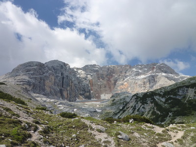
The hiker reaches the Plätzwiese tourist zone after crossing a wide ski run. After this, take trail no. 3a to the Stolla Alm meadow in the valley by the same name. From there, a mountain path then leads westward through woodland and across pastures on a slight incline to the Gumpalboden area. Still following the signs for trail no. 3, Via Alpina winds its way around the rock faces and taluses of the Hohe and Kleine Gaisl peaks. In the Gaislleite area, the trail section is rather difficult owing to its exposure and is therefore not as heavily used as the stages on other dolomite trails. However, this 6km stage is a fast and well worthwhile connection between the Plätzwiesen and the Obere Roßalm meadows (2,142m), where huts of unusual charm await the hiker. For those with less experience, it is possible to take the easier but longer alternative route via the Brückele alpine inn. From the upper Rossalm, continue to the north west along a gully trail up to the “Ofen“, a surprising stone landscape to the east of the Seekofel group. From this section of the trail, several tracks branch off in various directions. It is now necessary to always keep following the signs for trail no. 28, which leads over limestone blocks to the Cocodainscharte gap at 2,332m on the provincial border (glorious lookout point) and on to the day’s destination 1.5km away. The Seekofel Hut (2,327m) on the Fosses Alp is already located on the side of Cortine. The Prags dolomites form a wide curve between the Rautal and Höhlensteintal valleys around the Prags Wildsee lake, and represent a highlight in the dolomites scenery. The central mountain form is the Seekofel. Experienced hikers can climb it from the hut in one hour. The highest peak, however, is the Hohe Gaisl, a wild and lonely rock massif steeped in legend in the southern part of the group. (Stefan Illmer, Karin Leichter, AVS)
Natural and cultural heritage
The Fanes-Sennes-Prags nature park lies between the Pustertal valley in the north, the Gadertal valley in the west and the Höhlensteintal valley in the east; the provincial border (Bolzano/Belluno) is situated to the south, as is the border to the nature park. It comprises a surface area of 25,680ha. The Fanes area became known at an early stage owing to legends about the dolomites, but it was only later that its special landscape and natural properties gained general recognition; this was also the reason for its being placed under protection in 1980. The high plateaus of the Fanes and Senes Alps situated between the Rautal and Pragsertal valleys, the Prags dolomites with the Prags Wildsee lake, the Plätzwiesen meadows, the Dürrenstein, the mighty Hohe Gaisl group and the Kreuzkofel group are some of the most popular areas in the nature park. Due to its geological structure, the protected zone fits in with the overall dolomites picture. The landscape shapes in the nature park area are very diverse; this is due both to the differences in stone and to the repeated change in the shape-giving forces and evolutional processes of development; special mention should be made here to the influence of the Ice Age: sharp-ridged landscapes, hump-backed and U-shaped glacier valleys still remind us of it. In the post-Ice Age, it was above all the erosive and shaping power of water that continued to mould the landscape. Valley floors and hollows were filled in with scree and sand; this sometimes dammed up watercourses to form lakes, such as the Prags Wildsee or the Toblacher See. The geological variations can likewise be explained by the contrast between the thickly wooded outlying areas and the largely barren core of the protected zone. The flora and fauna of the area scarcely differ from that of the other alpine sections with similar climatic conditions. The border between the individual vegetation belts and the treeline itself can vary considerably. The alpine flowers include gentians, Turk’s cap lily, fire lily, lady-slipper, soldanella and round-leaved saxifrage as well as edelweiss, which all benefit from nature protection. The wildlife is also very diverse: there are ibexes, chamois, roe deer, foxes, badgers, squirrels, martens, marmots, eagles, falcons, hawks, capercaillie, jays and a great many ravens. The streams and lakes abound in fish, especially trout.
(Stefan Illmer, Karin Leichter, AVS)
Other long-distance trails and alternative routes
During this stage, Via Alpina crosses high altitude dolomites trails 1 and 3. It is best to start out from the Seekofel Hut to climb the Seekofel (2,810m, 1 hour, only for experience hikers).
Favourites, criticisms ? Make your personal comments on this stage. For more general notes please use the comments section of the page Over to the Via Alpinists.
Carsten - 2022-01-10
The Seekofelhuette, the pass after it, and the descent are boring and with the alternative I did (R27) it would have made sense to divert to the Sennes Alm about an hour before reaching the Seekofelhuette, and probably before actually reaching the Sennes Alm to head to the Seitenbachscharte (pass) from where a trail leads down to Wildsee, i.e. bypassing the Seekofelhuette / pass descent altogether. 20 min before reaching the Seekofelhuette another trail to Seitenbachscharte is signposted.
The regular descent from Seekofelhuette is unpleasant with on a late Sunday morning about 300 people stumbling through the narrow passages (and clogging up the trail for lengthy periods). The descent includes 2 secured passages of 50 and 20m; in R23 such passages were not secured. Here one could get by without the cables.
Veronique et Bruno - 2018-09-23
Après le refuge Biella nous sommes descendus jusqu'au lac Prags Wildsee. Le prix de le demi pension à l'hôtel Pragser Wildsee,est comparable à celui des refuges d'altitude avec en prime une vue magnifique sur le lac.
Automatic translation
[Google]
After the Biella hut we went down to Prags Wildsee lake. The price of half-board at the Pragser Wildsee hotel is comparable to that of the mountain huts with a wonderful view of the lake.
POPEYE GG - 2018-06-13
3 juillet 2017
C'est étape est théoriquement courte: ça tombe bien, car je la débute à partir de Höhlensteintal. Superbe étape, tant de la fin de la R27, que de cette R28, surtout avec ce beau temps!
A partir du Rifugio Vallandro, le chemin a été détourné, suite à la montagne qui s'était effondrée en juillet 2016: il faut prendre un bus qui nous amène 500m plus bas, puis prendre un chemin carrossable qui monte jusqu'à Rossalm: c'est lors de cette montée que je rencontrerai mes premiers français depuis le début de la randonnée, soit 27 jours! Là, spectacle sublime sur la montagne effondrée (Crossa Rossa).
A Rossalm, pas d'hébergement possible, seulement repas le midi.
J'ai donc continué jusque Rifugio Biella, ambiance très sympathique.
Une belle journée bien remplie avec ses 1900m de montée et 500m de descente (en plus des 500m en bus), d'autant que j'ai raté la direction de Cocodain et suis arrivé au refuge par un détour: pas grave, le cadre était si beau!
Automatic translation
[Google]
July 3, 2017 This stage is theoretically short: it's good because I start from Höhlensteintal. Superb stage, both from the end of the R27, than this R28, especially with this beautiful weather! From the Rifugio Vallandro, the path was diverted, following the mountain that had collapsed in July 2016: we must take a bus that takes us 500m lower, then take a road that goes up to Rossalm: c is during this climb that I will meet my first French since the beginning of the hike, 27 days! There, sublime show on the collapsed mountain (Crossa Rossa). In Rossalm, no accommodation possible, only lunch. So I continued to Rifugio Biella, very friendly atmosphere. A busy day with its 1900m climb and 500m descent (in addition to 500m bus), especially since I missed the direction of Cocodain and arrived at the refuge by a detour: no big deal, the frame was so beautiful!
Route number 3 between Ross Alm and the Dürrrensteinerhüte is officially closed, because of the risk of falling stones. The red "wall" comes down when it rains. There's a big landslide that washed the hiking trail away. They made a little detour, when I passed, it was allright, but not much later I heard a lot of noise when other hikers passed this part. That was really scary. Especially because at night there was an big storm that caused a lot of damage. A few kilometres further a road has been destroyed, just like the hiking trail, an huge landslide has "washed" away the road. This made me realize that official warnings and closed paths/roads are to be taken serious.
Water in the Seekofelhutte is stored in a tank, and is not drinkable. So bring up your own or buy water in bottles. Italian type of toilets!
Alpinisten - 2012-09-24
Können die Gehzeit von Jean-Louis Giraud ab Dürrensteinhütte bis Seekofelhütte bestätigen: 5h muß man dafür einplanen!
Automatic translation
[Google]
Can walk from Jean-Louis Giraud from Dürrenstein hut to confirm Biella: 5h must allow you to
Jean-Louis GIRAUD - 2012-03-28
L'étape est magnifique, parfois au mileu des pins cembro mais le plus souvent dans un environnement minéral et désertique ...Un livre ouvert sur l'origine des Dolomites et une vraie lecon de géologie !
Attention aux indications du Topo-guide ! Il y a manifestement une erreur sur la distance et sur les dénivelés ! La durée de l'étape R 28 vers le Refuge BIELLA est plutot de 5/6 h .Temps communiqué par le gardien du refuge VALLANDRO.
Faire des bises de ma part à la responsable du refuge BIELLA ou je suis arrivé avec un certain retard...
Automatic translation
[Google]
The stage is beautiful, sometimes in the middle of Arolla pine but more often in a mineral desert ... An open book on the origin of the Dolomites and a real lesson in geology!
Attention to the indications of the Guidebook! There is clearly an error on the distance and elevation changes! The duration of the step to the R 28 BIELLA Refuge is rather 5/6 h. Communicated by the time keeper Vallandro refuge.
Make kisses from me to the head of refuge or BIELLA I arrived with some delay ...
Pierre - 2009-08-15
Ici encore l'l'indication de dénivellé est erronée et nettement supérieure (environ 800 m), la distance est surement plus importante. Ce point mis à part, il y a des passages en balcons qui offrent une vue superbe.
Automatic translation
[Google]
Here again the difference in level indication is incorrect and much higher (about 800 m), the distance is probably more important. That point aside, there are passages in balconies with stunning views.

 |
4h35 |
12 km
|
404 m
|
52 m
|
4h35 |
12 km
|
404 m
|
52 m
 )
)


Favourites, criticisms ? Make your personal comments on this stage. For more general notes please use the comments section of the page Over to the Via Alpinists.