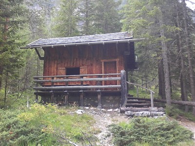
From the Sillianer Hut, take the Karnische Höhenweg trail to the cable car. It will bring you sown to Sexten. A dolomites high altitude trail leads through glorious woodland to the Talschluss Hut in the Fischleintal valley (1,540m). Follow the trail to the Bödenalpe meadow, near the stage destination. To reach it, there is a climb of almost 900m in altitude from the valley head.
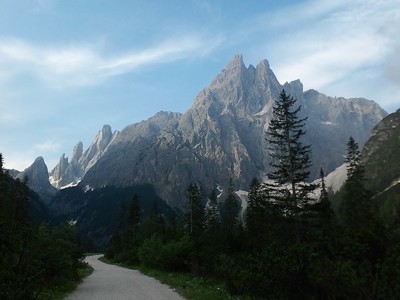
From the Sillianer Hut at 2,447m in altitude, walk along the Carinthian ridge trail in the direction of the Helm restaurant, the next stage location offering traditional local cuisine. This brings you over the Grenzberg Helm (2,434m) in the Hochpustertal valley quickly and easily to the Helm mountain funicular located further down, with the constant splendid view over the sea of dolomite mountains. The funicular is a handy way to reach Sexten (approx. 1,300m). Even seen from afar, the Sextental valley is an impressive sight. The main village of Sexten with a multitude of mountain farmsteads leans on the sunny slopes of the Helm and Mitterberg mountains. On both sides of the Sexten stream, the compact village centre presses around the elevated site of the church of St. Veit. The parish church, which was completely destroyed in the first World War, was built anew between 1920 and 1930. The dolomites ridge trail (no. 5), which Via Alpina also follows, starts in the centre of Sexten. It leaves the village to the south and in the form of a glorious woodland path (no. 1a) leads to the Dolomitenhof farmstead, which stands in a larch meadow in the Fischleintal valley. From here, it leads along the goods trail to the Fischleintal hut at the valley’s end (approx. 1,540m). On trail no. 102/103, climb in the direction of the Altsteinertal valley. After about 15 minutes, take the right-hand trail at the fork in the road to reach trail no. 102 heading uphill to the Drei Zinnen Hut. After the aforementioned fork in the road, ridge trail no. 5 leads into the Bacherntal valley to the Zsigmondy-Comici Hut. However, Via Alpina now follows the trail to the Bödenalpe, which is not far from the stage destination. From the end of the valley to here, hikers must make a climb of close to 900m in altitude. Owing to the easy trails and the clear signposting, there are no specific difficulties along this Via Alpina route. Mountain experience and security of foot are however required for the possible alternative routes, which lead to summits or along via ferrata. (Stefan Illmer, Karin Leichter, AVS)
Natural and cultural heritage
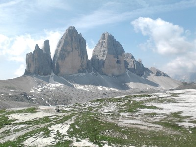
Since primeval times, people have taken the trail from the Pustertal via the Sextental valley and the Kreuzbergsattel pass to the south. The name of the Sextental valley derives from the Latin words “hora sexta“ (sixth hour after sunrise). The Sexten dolomites nature park was approved by the South Tyrolean provincial government in 1981; it covers a surface area of 11,650ha. There are many well-known mountain peaks in the nature park; the most well-known are probably the Drei Zinnen, the symbol of the dolomites, the Dreischusterspitze, the Paternkofel and the Haunold, to name only a few of the most beautiful peaks in the Alps. The dolomites are not in a chain formation but tower up in individual massifs, which posed a problem for through-traffic. For the high-alpine hiker, they offer ideal crossings and for the climber a sheer and inexhaustable kingdom of ridges, rock faces and towers. Geologically speaking, the nature park corresponds to the northeastern edge of the dolomites and offers the best insights into the complete strata sequence of geological conditions. During the Ice Age, mighty glaciers carpeted today’s nature park area. This caused headwater troughs to be shaped into cirques, rounding out valleys, and creating sharp-ridged and humpbacked landscapes and also side moraines. The tower-like rock shapes owe their appearance to the reciprocal action of the powers of weathering and the stratification or arrangement of the stones. Much of the nature park’s land consists in rock and loose stone. Extensive detritus and talus terrain starts at the foot of the dolomite rocks. The main sources of income for the people in the area aruond the Sexten dolomites are grassland farming and forestry and also livestock breeding and of course tourism. The tourist centres are mainly located to the north of the mountain group. The purpose of the dolomites ridge trails is to serve as a connection for the mountain huts using high-alpine paths or so-called “secured trails” in order to provide the walker with as complete an experience as possible of the various dolomite landscapes. The trails can be used by any good mountaineer without difficulty. Ridge trail no. 5 stretches over almost 100 kilometres, taking in eight mountain groups. It is marked with a 5 in a red triangle. To cover the entire trail length, it takes around 10 days. A series of landscape highlights make all of the effort worth while.
(Stefan Illmer, Karin Leichter, AVS)
Other long-distance trails and alternative routes
The approx 110km long Karnische Höhenweg ("Peace Trail“) was created after 1974 from a trail system built in World War One, which was used by Austrian mountain troops for supply purposes. Dolomites high alpine trail no. 5 uses varying tracks to head straight through the eastern Sexten dolomites, running in a wide loop around the Marmarole chain and reaching Pieve di Cadore.
Favourites, criticisms ? Make your personal comments on this stage. For more general notes please use the comments section of the page Over to the Via Alpinists.
Raphael - 2023-09-26
As previously commented, it is impossible to get a bed in the Dreizinnenhütte. I skipped the Silianerhütte after arriving there at 11 am already and took the cable car down to Sexten (20€ to go down, I would probably hike it next time). Also, the path from the Silianerhütte to the cable car station was packed with day-trip tourists and really easy to walk, which was a big contrast to the previous days. In Sexten I stopped for a resupply. From Sexten, I hiked to the Talschlusshütte and slept there (~40€ with breakfast). It is after 1.5-2h of R27. The next day, I hiked to Misurina and slept at the Camping Alla Baita. I was very happy with this planning and would recommend that to anyone!
Oliver - 2022-07-23
Since both huts of r26 and r27 are very tough to get a bed in, consider staying in Sexten instead (Hotel Willy, very recommended) and hike to Misurina where there is a campsite. From there hitchhike or walk to schluderbach to and hike to Prager Wildsee from there.
Oliver - 2022-07-18
The drei zinnen Hütte is booked out essentially all the way until the end of August.
Consider alternative routing options.
Carsten - 2022-01-10
Basic resupply at Despar in Sexten.
Frequent bus 446 (every 20min) up and down the valley (down to Innichen, which may or may not have better resupply options).
For resupply, also consider a side trip (bus) in R27.
A free hiking map available at the Sexten tourist office (in the entrance area when the office is closed) is useful through R29.
Lolo - 2018-08-12
Le dénivelé de cette étape (928 m annoncés) est faux, il est superieur à 1500 m. De sesto au refuge Locatelli c'est déjà 1100m.
Automatic translation
[Google]
The height difference of this stage (928 m announced) is false, it is superior to 1500 m. From sesto to Locatelli refuge it is already 1100m.
POPEYE GG - 2018-06-13
1er juillet 2017
Il a un peu neigé dans la nuit!
C'est la fin du Kärnerhohenweg (chemin frontière entre l'Italie et l'Autriche). Nous nous séparons Egon et moi, à proximité de l'arrivée de télécabine... que je ne prendrai pas. Le chemin est simple et les 1100m de descente sur Sexten se font sans problème. Premières vues sur les mythiques Dolomites.
Le beau temps revient, je passe devant le Rifugio al Fondovalle, et entreprends la montée sur le refuge Dreizinnenhütte; en cours de route je croise des randonneurs que j'avais vu précédemment, qui m'annoncent que le refuge est plein (on est un samedi, et tous les samedis sont réservés jusqu'au mois de septembre!). Je redescends donc sur le sympathique et moderne Rifugio al Fondovalle.
Automatic translation
[Google]
July 1st, 2017 It has a little snow in the night! This is the end of the Kärnerhohenweg (border road between Italy and Austria). We separate Egon and me, near the arrival of gondola ... that I will not take. The way is simple and the 1100m of descent on Sexten is done without problem. First views of the mythical Dolomites. The good weather returns, I pass the Rifugio al Fondovalle, and begin the climb on the refuge Dreizinnenhütte; on the way I meet hikers I had seen previously, who announce me that the refuge is full (it is a Saturday, and every Saturday are reserved until September!). So I go down on the friendly and modern Rifugio al Fondovalle.
I'm surprised that the route uses the Gondola, there's a marked hiking trail from (to) Sexten or you can go straight to ... where is also a supermarket, slightly expensive though.
tof - 2014-12-25
Trieste-Monaco le 20/7/14
Départ de Sexten vers les sublimes Drei-Zinnen. Pause à Locatelli puis descente sur le chemin de l'étape suivante. Orage, nuit dans une cabane ouverte à disposition des randonneurs. Propre, bien entretenue, balai pour nettoyer. Se nomme Jaghutte ou Rienzhaus sur la carte. Située à proximité du chemin avant l'arrivée à la route nationale.
Automatic translation
[Google]
Trieste-Monaco on 20/07/14 Departure from the sublime to Sexten Drei-Zinnen. Locatelli then break down on the way to the next step. Stormy night in an open cabin available for hikers. Clean, well maintained, broom to clean. Is called Jaghutte or Rienzhaus on the map. Located near the road before arriving at the highway.
Near the base station of the Cable-car in Sexten there is a tourist office. I asked them to inquire on free places in the Dreizinnenhutte. They told me that there were 100 beds, so I should not worry. So I climed up, and there I learned there were only 3 emergency-beds left: under the terrace next to the diesel generators. (Saturday, begin of July). No water or WC down there. Later I heard from people that did call up that they were told not to come up because they were full-up. My conclusion is just to go up and try your luck!
Knut Skarsem - 2013-06-23
No snow problems in the Dolomites. I just completed stages R26-R29, and the snow is no longer a problem 22 June 2013. The small snow patches still left will soon be gone.
Mountain Girl - 2012-03-29
If you plan to stay at either Talschluss hut or Drei Zinnen hut, it would be wise to reserve well in advance, as this area is extremely popular. The Hotel Tre Cime in Landro was also full when I visited in late June 2011, and since the managers treated me like a stray dog, I can't recommend it. The town of Toblach/Dobbiaco (11 km off-route) has a wonderful youth hostel in what was once the 'Grand Hotel'. Reservations here are also highly recommended.
Jean-Louis GIRAUD - 2012-03-28
Lors de mon passage, en Juillet 2011, le refuge DREI ZINNEN / LOCATELLI etait complet et envahi de touristes... Je n'y avais pas ma place. J'ai alors repris sac et batons pour continuer sur l'itinéraire R 27 . Je me suis arrété dans un hotel au fond de la vallée à proximité de la route de TOBLACH :
Hotel Résidence TRE CIME-DREI ZINNEN
Fam.Franchi-Baur
I 39034 Landro-Dobbiaco/Toblach (BZ)
Tel 00 39(0)474/972 633
Fax 00 39(0)474/972 330
www.hoteltrecime.com
Hotel de bord de route peu fréquenté le soir ou j'ai dormi. Possibilité de prendre le diner. Petit dejeuner correct et varié.
Le sentier vers le Refuge Vallandro (Fin étape R 27 ) passe juste derrière l'hotel .Parti tot le matin, jai pu enchainer R 27 et R28 jusqu'au refuge BIELLA .
Automatic translation
[Google]
During my visit in July 2011, the refuge Drei Zinnen / LOCATELLI was full and hordes of ... I had not my place. I then resumed bag and sticks to continue on the route R 27. I stopped at a hotel in the valley near the road Toblach:
TRE CIME-Residence Hotel Drei Zinnen
Fam.Franchi-Baur
I Landro-Dobbiaco/Toblach 39034 (BZ)
Tel 00 39 (0) 474/972 633
Fax 00 39 (0) 474/972 330
www.hoteltrecime.com
Hotel roadside unfrequented at night or slept. Opportunity to have dinner. Correct and varied breakfast.
The path to the Refuge Vallandro (End stage R 27) passes just behind the hotel. Parti early morning, i could enchainer R 27 and R28 to the refuge BIELLA.
Mountain Girl - 2011-11-07
Be prepared for big crowds at Drei Zinnen hut-- especially on weekends. Everyone converges here: climbers, day hikers, and distance hikers. Atmosphere is like a zoo.

 |
5h30 |
18.5 km
|
928 m
|
1013 m
|
5h30 |
18.5 km
|
928 m
|
1013 m


Favourites, criticisms ? Make your personal comments on this stage. For more general notes please use the comments section of the page Over to the Via Alpinists.