Hiking (mountain trail, in places narrow and exposed)
Alpine route (equipped or very exposed section, snow field, blocks)
R25
Obstansersee Hütte » Sillianer Hütte
|
4h20 |
12.5 km
|
549 m
|
403 m
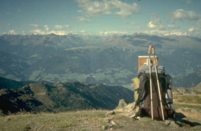
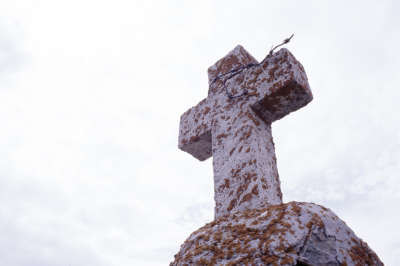
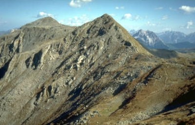
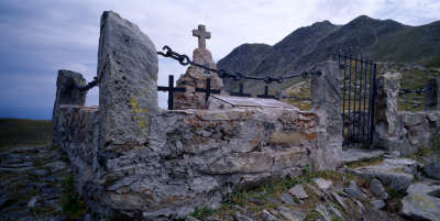
The trail leads you from the Obstansersee Hut initially over rocky, pine-strewn terrain. There are several peaks to climb before reaching the Sillianer Hut, such as the Eisenreich, which, standing at an altitude of 2,665m, is the highest point of the Karnischer Höhenweg (Carnic alpine trail). Continue over the Schöntalhöhe and the Demut before arriving in the Hochgränten Joch pass, where a military cemetery is situated.
This is the last stage on the Karnische Kamm ridge. It leads from the Obstansersee Hut along an initially pleasant upward route, repeatedly coming across World War I sites until reaching the Eisenreich at 2,665m, whose summit lies a little to the side of the trail. The most impressive aspect is the view into the lush valleys with the little settlements, the closely assembled dolomites and towards the North, the view over the Großglockner peak (approx. 1h 30min). A gentle descent takes you a little later to the turnoff on the right for Kartitsch. However, Via Alpina continues to follow trail 403 over the Schöntalhöhe and the Demut and from here, heads downhill to the Hochgräntenjoch pass with the little Hochgräntensee lake. This is the location of a little war graveyard, which recalls the horrors of the 1st World War (approx. 1h 25min). The trail now heads along a wide, well improved hiking trail on a slight incline over the Hollbruckerspitze peak. The trail gives you a view over the Hollbrucker lakes until reaching the 2,551 metre-high Hornischegg and – on Italian territory – the Sillianer Hut standing at 2,418m in altitude (approx. 1h 45min from the Hochgräntenjoch pass). (Christina Schwann, OeAV)
Natural and cultural heritage
World War I ended with the dispatch of a civil ceasefire delegation under the leadership of Matthias Erzberger. This was triggered by the hopeless situation on the western front and the collapse of allied Bulgaria. On 11 November 1918, Erzberger and Allied Supreme Commander Ferdinand Koch signed the armistice in a railway car in Compiègne forest, and it came into force on the same day. The conflict on the Carnic ridge, however, ended a little earlier, as the breakthrough of Flitsch-Tolmein in 1917 shifted the entire front westward as far as the Piave river. The Italians on the Carnic and eastern dolomites front were therefore taken prisoner. The military graveyard at the Hochgränten – the highest in Central Europe – reminds us of the many who lost their lives in the war. The wars left an entire network of supply routes behind on both sides of the border. They were used to create the Carnic ridge trail in the Inter-War Period, along which alpine shelters were established for mountain climbers. The growing popularity of the trail was seriously undermined by World War II and numerous huts and bivouacs, especially on the side of East Tyrol, were plundered and destroyed, and the trail thus fell into oblivion. In 1973, the friends of the dolomites association started to reopen the dilapidated former front-line trails in South Tyrol and in the Belluno region as "Peace Trails". The friends of the dolomites’ proposal to also revive the ridge trail on the Carnic ridge was welcomed by the central committee of the Austrian Alpine Club and a work agreement was concluded. Through the financial support of the club, it was possible to reconstruct the soldiers’ hut on the Filmoor, the new Porze Hut and the Mitterkar bivouac again. Sections of the trail were also restored. The official opening of the Carnic ridge trail as a peace trail took place within the framework of the inauguration of the new town hall of Kötschach-Mauthen in 1977. Today, the trails on either side of the border are so accessible that the guidance of travel documents has become unnecessary through accession to the EU. In addition to the extraordinary beauty of the Carnic ridge, its many fossil discoveries and its exciting geology, it will always remain a monument for future generations and a symbol of peace. (Christina Schwann, OeAV)
Other long-distance trails and alternative routes
South alpine long-distance trail 03, KGW Carinthian border trail. Geo-trail and peace trail.
Favourites, criticisms ? Make your personal comments on this stage. For more general notes please use the comments section of the page Over to the Via Alpinists.
Raphael - 2023-09-26
Don’t be confused by the official route on Komoot. This is an attempt to show that there are variants of the path. Mostly one path follows the crest and includes all peaks and the other, easier path goes below. The leg takes only around 4h.
Oliver - 2022-07-18
If you plan to do a longer stopover/resupply in Sexten you can consider skipping Silianer and just continue down to Sexten or to the cable car station. Both options are about 6:00 from Obstansersee.
Lolo - 2018-08-12
Le refuge Sillianer est actuellement en travaux, on ne peut pas y dormir
Automatic translation
[Google]
The Sillianer hut is currently under construction, we can not sleep there
POPEYE GG - 2018-06-13
30 juin 2017
Il fait une température de 5°C au départ de cette journée.
Temps mitigé, il y a même du vent en descendant sur le refuge Silianerhütte, où nous croisons d'intrépides cyclistes! Enfin, chacun son plaisir!
Automatic translation
[Google]
June 30, 2017 The temperature is 5 ° C at the start of this day. Mixed weather, there is even wind down the Silianerhütte refuge, where we meet intrepid cyclists! Finally, everyone's pleasure!
At Sillianer Hütte near the bunker, there's a good spot for camping (out of the wind). Super friendly staff at Sillianer Hütte and free WiFi (!).
tof - 2014-12-25
Trieste-Monaco le 18/7/14
Voulant éviter Sillianer et faire une pause, je prends la direction de Sexten. Petits budgets, passez votre chemin ! Le camping (à 10 minutes de bus du centre) est loué pour un emplacement à 50 euros pour 2 jours. Moustiques inclus.
A Sexten, tous ravitaillements possibles.
Automatic translation
[Google]
Trieste-Monaco on 18/7/14 Wanting to avoid Sillianer and take a break, I take the direction of Sexten. Budget, go your way! Camping (10 minutes from the center of the bus) is leased to a location 50 euros for 2 days. Mosquitoes included. A Sexten all possible supplies.
Stay at the Sillianer Hutte. The Hahnhutte most probably does not have any accomodation, and from the Sillianer Hutte you have plenty of time to reach the first cable car down at 8.30 am.

 |
4h20 |
12.5 km
|
549 m
|
403 m
|
4h20 |
12.5 km
|
549 m
|
403 m


Favourites, criticisms ? Make your personal comments on this stage. For more general notes please use the comments section of the page Over to the Via Alpinists.