Hiking (mountain trail, in places narrow and exposed)
Alpine route (equipped or very exposed section, snow field, blocks)
R24
Neue Porze Hütte » Obstansersee Hütte
|
5h35 |
14 km
|
1185 m
|
801 m
From the Porze hut, walk across entirely high alpine terrain past the Fillmoor-Standschützen hut, where a short rest can be fitted in, to the Obstansersee Hut. The trail starts off below the steeply towering walls of the Porze up to the Heretriegel and through the marshy terrain of the Obere Stuckensee lake, which can heat up to 19 degrees in the summer.
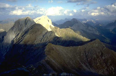
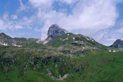
From the refuge, the trail initially leads down into the Porzekar cirque, where the trail branches off into the Obertilliacher Tal valley. However, Via Alpina follows the trail northwards and below the Roßkarspitze peak, climbing up to the Heretriegel mountain at 2,170m. Head down to the left here and you will soon have a wonderful view over the Untere Stuckensee lake. The trail takes a sharp turn to the left, after which you head gently downhill under the rugged rock faces until reaching the Leitnertal valley and the lovely Obere Stuckensee lake. Now head along the left banks of the lake into the valley. The trail starts to climb again and leads over the marshy Filmoor moorland and you will arrive at the Filmoor-Standschützen Hut (approx. 3h 20min from the Porze Hut), all the while enjoying a view over the Königswand (2,686m), which closely resembles the Matterhorn. From the Filmoor-Standschützen Hut, cross the precipitous slopes of the Königswand to arrive at the Hintersattel pass. From here, the trail slips down to the Tscharr Hut in the Erschbaumertal valley. Keep to the left around some steep hairpin bends and finally crossing debris-strewn terrain on an upward climb to the 2,493 metre-high Roßkopftörl pass. From here, you can see down to the Obstansersee lake and the Obstansersee Hut located on its banks. Head steeply downward over boulders to the refuge (approx. 3h from the Filmoor-Standschützen Hut). The trail from the Filmoor-Standschützen Hut over the 2,678 metre-high Pfannspitze peak to the Obstansersee Hut offers an alternative route. The trail is not any longer, but it is a little more exposed and difficult to walk along. (Christina Schwann, OeAV)
Natural and cultural heritage
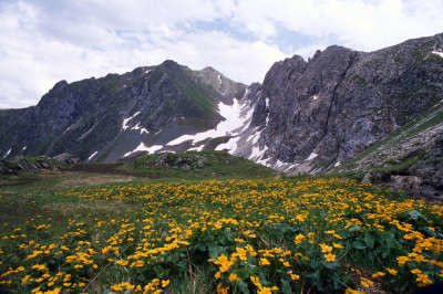
The mountain chain of the Carnic ridge is blessed with plentiful rainfall, which is indicated in the farmland name of "Naßfeld" and in the valleys, above all through their extremely rich and verdant vegetation. In the other limestone mountains, there are only a few lakes, especially in the areas where build-ups of clay, marl, slate and moraines occur. Most of the water seeps away, only surfacing again deeper in the valleys in the form of springs and streams. The Carnic ridge therefore forms not only a political border but also a weather divide and watershed. On the way to the Obstansersee hut, the trail first reaches the Obere Stuckensee lake, in which the silent water from the Filmoor moorland higher up is collected. The vegetation around the lake is extraordinarily diverse. In earlier times, the grass on the slopes was mostly mowed, to create the now abandoned hay barns. An old farming landscape that could today disappear due to its inaccessibility and the excessive effort required. Unimaginably, the mountain meadows in the Leitental valley changed hands for a few baskets of bread during a famine at the turn of the century. At the foot of the Roßkopf lies the Obstansersee lake, which with its 2ha is not only one of the largest but also the most beautiful lakes on the Carnic ridge. There are normally no fish in mountain lakes, unless they were put there. The Obstansersee lake has contained fish possibly since the time of Emperor Maximilian I, who was already using numerous high mountain lakes for fishing purposes. The Obstansersee lake is particularly inviting at the time of the "Primelfest" festival, when an endlessly carpet of blue violet blossoms of the sticky primrose stretch up towards the sunlight. On the onward route and actually already on the next stage, the trail reaches the Hochgräntensee lake, on whose shores stands a war memorial. The name "Hochgränten" is said to come from "Granten", which refers to a trough or a dip. This picture probably comes from the vast sink on the ridge, in which this lake shares the space with the monument in earnest peace. (Christina Schwann, OeAV)
Other long-distance trails and alternative routes
South alpine long-distance trail 03, KGW Carinthian border trail. Geo-trail and peace trail. Variations: from the Porze pass on the Sentiero d´Ambros Corrado via ferrata to the Filmoorsattel pass. From the Filmoor-Standschützen-Hut- Filmoor pass trail 160 to the north north past the Gr. Kinigat/M.Cavallino (can also be climbed, 2,689m) - Pfannspitze/Cma Vanscuro 2,678m - Obstansersee Hut.
Favourites, criticisms ? Make your personal comments on this stage. For more general notes please use the comments section of the page Over to the Via Alpinists.
Ingo - 2023-09-30
If you want to skip Obstanserseehütte, there is a good option! You climb Pfannspitze, but then only follow the official trail down towards Obstanserseehütte for about ten minutes. Then you reach a sign that indicates "Eisenreich 2 hours". You have to follow that trail! It´s quite easy walking, a bit up and down, no difficulties at all. We reached Eisenreich within one and a half hours and eliminated 150 or 200 metres of elevation loss (and gain on the other side).
Valentine - 2023-07-13
You have to stop to Filmoor Hütte. It’s a family hut, they are running it for more generations. The place is amazing, the staff is just so nice and the food was the best we had so far (thanks Alberto). We had our best night here, and the schnaps was by far not the only reason :)
Julien Trieste Monaco - 2022-08-15
Left the 403 trail for good at Filmoor Hütte due to bad weather.
Went to Filmoor saddle and from there to malga Della manze and passo Silvella. Really easy going and doable in bad weather. Ended up at Sesto but you can stop at Malga Nemes.
Had lunch at Filmoor Hütte as I was running out of food. Best food so far on trail. They prepared a meal that was as good as what is prepared at really good restaurants. And nice staff too.
Oliver - 2022-07-21
Sorry the previous comment should be pass cavalino on the Westside rather than on the Eastside as the gpx indicates.
Oliver - 2022-07-21
The gpx track after Filimoorhut should be considered as a super bad weather alternative. In normal conditions it makes no sense to follow this track at all. Not only does it add 500 unnecessary vertical meters but it also robs you of the splendid view from the Pfannspitze. After Filimoorhut just follow the marked 403 trail following the ridge and pass monte cavalino on the Eastside Rather than descend on the west as the gpx indicates. It is a well maintained path with glorious views and I would only consider skipping it in very bad weather conditions. Also, consider staying at Filimoorhut, it has a super nice team an location.
Carsten - 2022-01-10
After descending on the Italian side in the direction of the end of R24, in continuingly bad weather, I used the app Maps.me to find a valley route to Sexten; the route turned out to be on hiking trails, forest roads, and occasionally on country roads. There are dozens of signposted trails in the lower regions, off the ridge. I enjoyed a mostly rain-free and at times even sunny day while the ridge was in clouds all day. (I covered a bit more distance as well as elevation gain than the official R24-R26 stages to Sexten do, and walked into Sexten rather than taking a gondola. And I saw some interesting villages rather than clouds only.)
Veronique et Bruno - 2018-09-23
Attention à bien tourner à gauche à hauteur du refuge et à le laisser sur votre droite (il s'agit d'une simple cabane non gardée) Tscharrhütte dans la vallée d’Erschbaumertal.
Automatic translation
[Google]
Be careful to turn left at the height of the refuge and leave it on your right (it is a simple hut not guarded) Tscharrhütte in the Erschbaumertal valley.
POPEYE GG - 2018-06-13
29 juin 2017
Temps pas très engageant encore aujourd'hui, mais qui s'est amélioré en arrivant au premier refuge (Filmoor-Standschützenhütte), et finalement nous décidons de continuer. A l'arrivée à la Obstanserhütte, un hélicoptère faisait des rotations pour acheminer les matériaux pour l'amélioration de l'unité de traitement des eaux du refuge (du moins, c'est ce que j'ai compris).
Automatic translation
[Google]
June 29, 2017 Not very exciting time today, but improved on arriving at the first shelter (Filmoor-Standschützenhütte), and finally we decide to continue. Upon arrival at the Obstanserhütte, a helicopter rotated to deliver materials for the improvement of the shelter's water treatment unit (at least that's what I understood).
Filmoor and Obstanersee Hütte have no problem with camping. A bit below the Neue Porzehütte there is a lake, the Klapfsee which has an excellent tenting spot. The GPS track differs from the marked route between Obstanersee and Filmoor. I followed the marks and hiked the ridge trail on the border. Even though it was completely covered with clouds and super windy, it was beautiful. At Filmoor Hütte it was nice and quiet, such a difference with the other places. I sure recommend staying or camping there.
tof - 2014-12-25
Trieste-Monaco le 18/7/14
Neige dans la descente pour Obstanserseehutte. Petit déjeuner copieux à ce refuge.
Automatic translation
[Google]
Trieste-Monaco on 18/07/14 Snow in the descent Obstanserseehutte. Hearty breakfast at this refuge.
The Porze- and Obstanzerseehutte are hotel-like huts. If you prefer the small-scale isolated mountain huts, stay at Filmoor.
Giovanni Mazzolani - 2011-02-21
Lo scorso luglio, con mio figlio ho pernottato al Filmoor. Ottima ospitalità e menù abbondanti con varie scelte. Ringrazio il gestore Gunter per l'indicazione dell'itinerario di discesa a valle, avendo mio figlio un trauma a un ginocchio per caduta.
Giovanni Mazzolani Italia
Automatic translation
[Google]
Last July, with my son I've been to Filmoor. Great hospitality and abundant menu with several choices. I thank the manager Gunter to indicate the route down to the valley, my son had an injury to a knee drop.
John Mazzolani Italy

 |
5h35 |
14 km
|
1185 m
|
801 m
|
5h35 |
14 km
|
1185 m
|
801 m


Favourites, criticisms ? Make your personal comments on this stage. For more general notes please use the comments section of the page Over to the Via Alpinists.