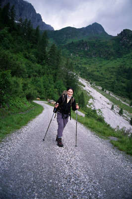
Hiking (mountain trail, in places narrow and exposed)
Alpine route (equipped or very exposed section, snow field, blocks)
R23
Hochweißsteinhaus » Neue Porze Hütte
|
8h25 |
21 km
|
924 m
|
841 m
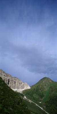
From the Hochweißsteinhaus lodge, Via Alpina takes you mostly over Italian territory to the Porze hut. Old war shelters are dotted all along the Höhenweg (high-altitude trail). This is a high-alpine stage which, as of the Luggauer Törl, already runs without exception at an altitude of over 2,200m. It is imperative to check that the trail and weather conditions are good.
The next stage is quite long, but its high-alpine character and wonderful vantage points are enchanting. From the Hochweißsteinhaus lodge, follow the 403 trail markings in a large curve to the right, circumventing the Krummholz slopes down from the Weißsteinspitze peak. About 20min after the refuge, a steep snow gully that cannot be seen beforehand must be crossed. In icy conditions, it is therefore advisable to use crampons, or else take the little detour around this part of the trail descending to the Frohnalm meadow and climbing back up along trail no. 452. After the snowfield, the trail follows a gentle incline and meets the aforementioned trail no. 452 coming from the Frohnalm meadow. Follow it to reach the Luggauer Törl pass after approx. 1h 30min, which stands at 2,226m in altitude. Now continue on the well maintained wartime trail alongside the slopes of the Torkarspitze to the Luggauer Sattel pass. Here, keep following the 403, cutting across the steep slopes. Once below the Steinkarspitz summit, keep to the left however and follow the "Via alta carnica" on Italian territory, while trail 403 takes a sharp turn to the right and leads on over the Zehrerhöhe elevation. Walk on above the Walische Kar cirque to reach the Forcla Vancomum over the Val Grande and from there, head down into the Hochspitzsenke valley. Again, keep to the left and follow the “Via alta carnica” along the Austrian-Italian border on a constant gentle incline over the Gamskofel to the Winklerjoch pass (approx. 4h from the Luggauer Törl pass). At the Winklerjoch pass, keep left again and follow the markings passing below the Reiterkarspitze peak, where the trail takes a turn to the West. A slight descent takes you to the Kesselscharte wind gap and, again keeping to the left, climb gently uphill and later slightly downward, passing below the Bärenbadegg mountain. After the Bärenbadegg, walk uphill again and then slightly downward to the 2,094 meter-high Tilliacher Joch pass. Back on Austrian territory again, go down now to the Porze Hut, standing at 1,642m in altitude (approx. 3h from the Winklerjoch pass). (Christina Schwann, OeAV)
Natural and cultural heritage
After Maria Saal, Maria Luggau is the most frequently visited place of pilgrimage in Carinthia (35,000-40,000 visitors per year). Fruthermore, Maria Luggau can be described as the historical centre of the Lesachtal valley, as in addition to the Marienwallfahrtskirche (Pilgrimage Church of St. Mary ) it also boasts a Servite monastery, four old watermills and several old farmhouses. Some of the high valleys to the south of the Carnic ridge were settled by people from East Tyrol and Carinthian farmers. Due to the economic situation, they had to move further south. That is why German speech islands such as Sappada (Bladen) for instance formed in Upper Italy. In times of peace, the “southern neighbours” came to Maria Luggau on pilgrimage every year. Over the generations, modest trade contacts, shared employment sources and mixed marriages have created friendly connections. The border on the Carnic ridge has existed since the time of Empress Maria Theresia. Smugglers have always used the mountain regions, which are difficult to control, as secret crossings and thus were able to boost their income a little. While before the first World War, smugglers on both sides of the border were hounded by the police, they were suddenly in great demand once the war started. For no one knew the trails and paths on either side and above all in darkness better than the smugglers. Quite a few lawless people helped military commanders achieve success using their alpine experience and knowledge of the local conditions. The fight for the Porze (cima palombino) peak could also only be conducted with the help of soldiers native to the Lesachtal valley. All points of access over the Tilliacher Joch pass were kept under Italian surveillance, so that only the steep ascent up the north face to the summit remained. The occupation was initially crowned with success, but the Italians closed their circle around the Porze ever tighter; the fight for the Wildkareck and the Rosskarspitze had to be abandoned. The troop on the Porze asked several times for relief, as the men were eventually approaching exhaustion due to the poor supply possibilities and the cold, sleepless nights. But as all of the troops were indispensable, it was necessary to beat a retreat on 18.6.1915 after three days on the peak. When the Italians stormed the peak in the early hours of the morning, they only found empty positions. From then on, the Porze peak remained firmly in Italian hands, which gave them a great strategic advantage, as the advance routes of the Austrians could be seen from here as far as Obertilliach in the Lesachtal valley. The village inhabitants must have been trembling with fear, as the Italians from time to time fired shots into the little community. (Christina Schwann, OeAV)
Other long-distance trails and alternative routes
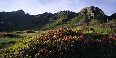
South alpine long-distance hiking trail 03, KGW Carinthian border trail. Geo-trail and peace trail. Summit climbs: Torkarspitze /M. Pietra Blanca (2,513m), Steinkarspitze /M.Antola (2,524m), Reiterkarspitz/M. Cecido (2,421m), Bärenbadeck/Croda Nera (2,430m), Porze/Cma. Palombino (2,559): Via ferrata Austriaweg from the west, via ferrata Via dei Camosci from the east.
Favourites, criticisms ? Make your personal comments on this stage. For more general notes please use the comments section of the page Over to the Via Alpinists.
Ingo - 2023-09-30
If you choose the easier way on the Italian side, you have to follow trail 448 up to Hochalpljoch, then trail 134 down to Malga Chivion and then trail 170 for the rest of the day: First to Malga Antola, then Malga Ciastellin, Malga Campobon, Tilliacher Joch and Porzehütte. Walking time 9 hours is correct. All the Malgas on the Italian side were closed on the September day that we hiked this section, but some may serve food in the summer. Other hikers said Malga Campobon was open the day before we came, so maybe we just picked the wrong day.
Julien Trieste Monaco - 2022-08-15
Beautiful section I did at sunset. No one the trail, very peaceful.
Pörzehütte is another place I recommend as cakes are really good and staff very nice.
Oliver - 2022-07-19
If you intend to take the alternate route on the Italian side I suggest you descend past the Refugio sorgenti di Piave to the West and ascend the other side of the valley. The trail coming down from Hochalplpass in WNW direction is an alternative but it is not recommended. It is completely overgrown with hip to shoulder deep vegetation. The trail is barely visible and often can't be seen due to foliage. Especially in the morning you'll be completely soaked after the one hour descend. It's also quite slippery due to all the leafs and grass on the trail.
The regular exposed path is okay as of early July. No ice before luggauer thörl. I would still recommend the path over the Frohntal. The area with the possible snowfields experienced some landslides and is difficult to pass.
If continuing over the regular path to Porze - take the "einfacher Weg", when the signs indicate it. It's just on the other side of the "schwerer Weg" and both will reconnect later.
I would highly discourage the regular path in bad weather. Take alternative "403a" over Malga Campobon.
Carsten - 2022-01-10
Similar to 10A but longer and more exposed. This is not a hiking trail as there are many instances of scrambling, and passages with (much needed) ropes and iron footholds. In many locations the trail is dilapidated / in urgent need of maintenance in order to be safe(r), for example where steel and wooden steps have broken away. I suggest to view the R23 currently described in the guidebook as a challenging 'Alternative.'
The safe way (a hiking trail) goes from Hochweisssteinhaus via (likely) the Hochalplpass to the Italian side, where it follows a comfortable, hikeable dirt road; close to the Porze hut (end of stage R23), signposts point away from the dirt road to the Porze hut. Old comments on R23 in the guidebook provide a bit more detail, and describe possibilities to overnight. (In bad weather, I started out on the R23 as described in the guidebook and three-quarters the way to Porze hut descended to the Italian side.)
POPEYE GG - 2018-06-13
28 juin 2017
Le temps n'étant pas annoncé beau, nous décidons Egon et moi de prendre par la variante, qui est aussi très belle. Là-haut, on aurait rien vu!
Finalement temps très acceptable sur les 3/4 du trajet, mais on arrivera trempés au refuge, cette dernière partie se faisant heureusement sur un large chemin carrossable.
Automatic translation
[Google]
June 28, 2017 The weather is not announced beautiful, we decide Egon and me to take the variant, which is also very beautiful. Up there, we would have seen nothing! Finally very acceptable time on 3/4 of the way, but we will get soaked at the refuge, this last part being done happily on a wide road.
I hiked the Almenweg (Strada delle Malghe), because the weather has been very unstable, I didn't dare the ridgehike.. Halfway I slept at Malga Antola, a very basic place, but super charming. It's a place that's still unspoiled by tourism, characteristic and traditional. I liked it a lot. Camping is also possible there.
tof - 2014-12-25
Trieste-Monaco les 16 et 17/7/14
Temps à l'orage sur les 2 jours.
Utilisation de la variante italienne (strada delle malghe n°132 et 134). Prévoir une carte pour orientation. Sentier très joli parfois en balcon.
Possibilité ravitaillement et couchage à Malga Antola. Autres malghe fermées. Bivouac le 16 à côté de la Malga Cecido.
Le 17, passage au Tilliacher Joch. Petit déjeuner à PorzeHutte (mon meilleur apfelstruddel du voyage!), puis direction Obstanserseehutte. Cause orage, nuit dans cabane ouverte nommée Tscharrhütte (voir la carte) avant la montée au Roßkopftörl. Cabane en bon état, balai pour nettoyer.
Automatic translation
[Google]
Trieste-Monaco on 16 and 17/07/14 time the storm over the 2 days. Using the Italian variant (Strada delle Malghe No. 132 and 134). Provide a map for orientation. Very nice trail sometimes balcony. Feeding and sleeping possibility Malga Antola. Other Malghe closed. Bivouac 16 next to the Malga Cecido. 17, passage Tilliacher Joch. Breakfast at PorzeHutte (my best apfelstruddel the trip!), Then towards Obstanserseehutte. Cause storm overnight in open cabin named Tscharrhütte (see map) before the climb to Roßkopftörl. Cabin in good condition, broom to clean.
Elisabeth - 2012-12-09
Deux erreurs dans le topo-guide : le sentier 403 suit bien la Alta Via Carnica ; le refuge Porze n'est pas à 1642m mais à 1942m, donc tout près du col Tilliacher (2052m). Si l'on veut camper, il faut s'arrêter avant le col.
Faire le plein d'eau avant de partir, car sur cette très longue étape, il n'y en a pas jusqu'au col Tilliacher.
Automatic translation
[Google]
Two errors in the guidebook: 403 trail follows much the Alta Via Carnica the refuge is not Porze 1642m to 1942m but, so all the Tilliacher pass (2052m). If you want to camp, you must stop before the pass. Fill with water before leaving, because on this very long stage, there is not to pass Tilliacher.
During bad weather -like I had- it is advisable to take the lower road on the Italian side. It is an easy type B road, without too many climbs. On the way you will pass Malga Antola -a mountain dairy farm. GPS:46.6428,12.6974. Do not pass by! You will meet Guiliano and Marino, two elderly men who serve a lunch with self made cheese from raw-milk (!), bread and plenty of wine. There is also a dormitory. Guiliano speaks a little German, but his native tongue is 'Ladino' -a local language. The overnight stay was very pleasant!
Later you will stop at Malga Manzon. GPS:46.6419,12.6356. They served me coffee, bread and home made cervelat wurst. They put another sausage in my pack, and refused any payment! They have private rooms.
And there is small refugio just before the Porze pass at 46.6451,12.6025, it seemed unmanned.

 |
8h25 |
21 km
|
924 m
|
841 m
|
8h25 |
21 km
|
924 m
|
841 m
 )
)


Favourites, criticisms ? Make your personal comments on this stage. For more general notes please use the comments section of the page Over to the Via Alpinists.