Hiking (mountain trail, in places narrow and exposed)
Alpine route (equipped or very exposed section, snow field, blocks)
R20
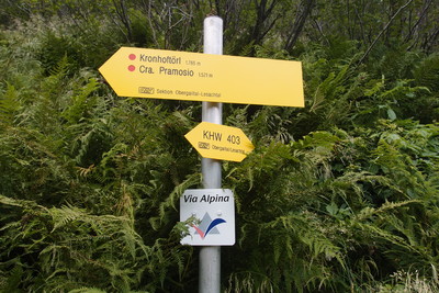
Zollnersee Hütte ehm. Dr. Steinwender Hütte » Untere Valentinalm
|
6h00 |
22 km
|
818 m
|
1358 m
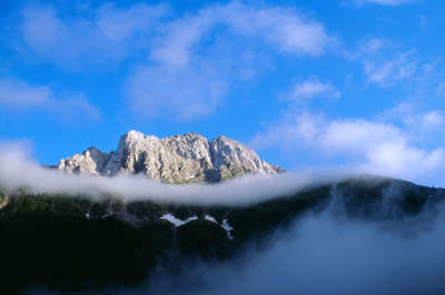
The trail leads across the meadowland of the Obere Bischofalm and over the 2,167m high Köderkopf, from which you can enjoy a wonderful view. This climb is followed by a descent across alpine grass and later through an area of gnarly trees predominantly overgrown with alders to the Obere Tschintemuntalm pasture. An old military cemetery bears witness yet again to the senselessness of wars, in which there can only be losers.
From the Dr. Steinwender Hut, follow the signs towards the North-West, arriving after a short descent at the Obere Bischofalm meadow. From there, the trail first of all leads slightly downward, but then it follows the slope at an altitude of 1,500 to 1,600m. After crossing the headwaters of the Aßniztgraben rift, which flow through the Kronhofgraben rift into the Obere Gailtal valley, the trail leads on a rather steep uphill course until reaching the highest elevation of this tour, the Köderkopf standing at 2,167m in altitude (approx. 3h). A very beautiful view can be enjoyed from here over the peaks of the Plöckengebiet area. A steep descent through the Krummholz region strewn with alders takes you to the Obere Tschintemuntalm and later the Untere Tschintemuntalm meadows. The trail continues along the Angerbach stream on a forest road. It is possible to make a short detour to the military cemeteries. Pass the Grünsee lake to reach the Plöcken Pass road and the "Plöckenhaus" lodge, situated directly on the road. As the inn no longer offers overnight accommodation, make the approx. 20min climb over the Theresienhöhe area to the Untere Valentinalm meadow (approx. 3h from the Köderkopf). (Christina Schwann, OeAV)
Natural and cultural heritage
The Plöcken pass is the shortest connection between the Gailtal valley and the Poebene plateau. This was appreciated as far back as Roman times. The name of the Valentinalm meadow derives from the Roman emperors Valerianus und Valentinian, under whom the trail over the pass was improved in 393 A.D. In World Wars I and II, the area around the Plöcken pass was hotly disputed. In the Plöckenhaus inn today, illustrated documents on the terrible war can still be found. 1,756 Austrian solders in total were laid to rest in the military graveyard here. A little chapel was built in memory of the many men who lost their lives not far from the Plöckenhaus. One of the 5 Geo-Trail nature paths starts at the Plöcken pass, as an extraordinary discovery was made in an avalanche channel of the Cellon section (“Cellonettarinne”): rocks from the Silurian Period can be found over a distance of about 60m, such as does not exist in any other site in Europe in such complete sequence. The base of the Cellon section is formed by various coloured limestone, psammitic limestone and slate. It can be seen from the fossils in the rock that they were deposited over a period of more than 50 million years layer by layer on a flat ocean bed. Their age stretches over a period of 450 million to 400 million years. This is followed by even younger limestone reaching up to the summit. Here, entire, completely preserved ammonites and sea lilies can be found. The undisturbed deposit and the frequent occurrence of the fossils make it possible to subdivide this section further and to compare it with rocks in other areas of the earth of a similar age. That is why this rock sequence is a type of standard for this time in the evolution history of the Alps. This special place was discovered towards the end of the previous century and its rocks and various fossil groups have been repeatedly subject to detailed scientific investigations. Painted numbers are dotted along the edge of the trail, marking the sites from which sample material was taken. On the trail between the lower Valentinalm meadow and the Valentin Törl pass, Via Alpina also crosses an ocean bed that is over 400 million years old. At every step, hikers can find fossilised corals and sponges, mussels and starfish. (Christina Schwann, OeAV)
Other long-distance trails and alternative routes
S. alpine long-distance trail 03, KGW Carinthian border trail. Geo-trail and peace trail, "Roman Way"/Sentiero Via Romana v. Kötschach-Mauthen - Timau, Museumserg /Sentiero Storico v. Plöckenhaus - Bar Laghetti; via ferrata on trail: Kl Trieb /Pta. Medatte 2,095m and Gr. Trieb/Cuestalta 2,199m, Frischenkofel/Cellon 2,238m, Kollinkofel/Creta di Collina 2,689m, Klabauter track in the Mauthen ravine.
Favourites, criticisms ? Make your personal comments on this stage. For more general notes please use the comments section of the page Over to the Via Alpinists.
flautix - 2023-08-21
Eine sehr schöne Etappe bei gutem Wetter! Wege sind zum Teil sehr schmal, aber für geübte Bergwanderer mit Stöcken m. E. kein Problem. Deutlich sichtbar sind noch die Schützengräben aus dem 1. Weltkrieg oben an der Grenzlinie am Köderkopf. Wer über den Wahnsinn dieses unsinnigen Krieges in den Alpen mehr erfahren will, sollte das Museum in Kötschach-Mauten besuchen.
Untere Valentinsalm mit neuen Pächtern. Gutes Essen, nette Bedienung! Kleiner Hinweis für große Leute: die Betten in den hübschen Doppelzimmern sind nur 1,9m lang!
flautix - 2023-06-06
Gute Nachrichten: es gibt jetzt neue Pächter auf der Valentinsalm und ab sofort kann wieder online gebucht werden: Birgit und Andreas Pernull, Hüttentelefon: +43 660 6799784, Mail nach wie vor: info@valentinalm.at
Der Link zur Onlinebuchung befindet sich auf der Website:
https://www.valentinalm.at/
flautix - 2023-03-19
Vom derzeitigen Pächter der Valentinsalm, Bruno Neumayr, kam gestern folgende Info: Sein Pachtvertrag wurde nicht verlängert. Meine bereits bestätigte Reservierung auf der Valentinsalm für den Sommer wurde daher storniert. Buchungen sind im Moment dort offensichtlich nicht möglich! Die richtige Mailadresse der Valentinsalm lautet: info@valentinalm.at
Julien Trieste Monaco - 2022-08-15
The way up to Köderkopf was clear of vegetation at the time I hiked it.
That being said, I confirm Oliver's word. This trail can be dangerous by rainy conditions. It was also pretty unpleasant despite the good weather as it was too demanding (too steep and requiring persistent attention).
Ended up at Untere Valentinalm. Owner not so friendly. 25€fpr a bed in a dorm. Camping prohibited in the valley.
Oliver - 2022-07-18
Unfortunately the trail vegetation was only maintained in some areas. Large sections are hip to shoulder deep overgrown which makes seeing, hitting and staying on the trail quite difficult. In dry conditions no Problem, but since I crossed in the morning after a thunderstorm the previous night I was soaked to my underwear by the time I got to the top. The way down is also no trifle in wet conditions and sticks help immensely.
If you have little experience in the mountains or have issues with exposed trails I would advise to take an alternate route if conditions aren't ideal.
That said, the episode offers stunning views and I enjoyed it immensely, even though it requires a lot of concentration and focus for long periods of time.
Oliver - 2022-07-18
Carsten's comment is a bit dramatic for my taste but there is some truth to it. The trek over the Köderkopf will take you 4-5 hours ascend+descend. Do not get caught in bad weather since there is no real alternative/escape. The trail on both sides is in parts moderately steep, narrow and in parts washed out. There are several parts where you have room for exactly one foot and since none of the broken sections have cables or reinforcements I found myself clinging at hazelnut bushes to balance through. Especially because the trail is fairly exposed at times.
Carsten - 2022-01-10
Worst section of the Via Alpina so far. Except for beginning and end, the trail deteriorates into a track that is exceedingly difficult to walk. Be prepared to slip: walking sticks as support are almost a must, gloves to protect one’s hands when one slips, long pants as protection against the undergrowth (and stinging nettles at one place on the descent). Much of the difficult track consists of crossing steep slopes, plus a steep descent. The scenery does not warrant this painful track. The vegetation suggests that this is a particularly rainy corner. Halfway down the descent, the signposted trail diverges from the GPS (and the trail indicated by the GPS coordinates no longer exists).
Alternative: Consider descending from the Zollnersee Huette (beginning of R20) to the town of Mauthen to resupply (Maps.me will display a walking route) and then returning to (almost) the end of R21(?) on a small road that runs parallel to (though distant from) the main road (or check for a bus).
POPEYE GG - 2018-06-13
25 juin 2017
Compte tenu des prévisions de mauvais temps, et du besoin d'argent liquide (en Autriche rarement possible de payer en carte bleue, même parfois dans les hôtels en plaine!), j'ai quitté momentanément la Via Alpina et suis descendu sous la pluie battante sur Mauthen (très touristique et cher) puis le village voisin Kötschach. J'y ai trouvé un hôtel qui reçoit aussi des groupes de motards, mais qui n'accepte pas la carte Visa.
Le temps est redevenu beau à l'arrivée!
Automatic translation
[Google]
June 25, 2017 Given the forecast of bad weather, and the need for cash (in Austria rarely possible to pay in blue card, even sometimes in hotels in the lowlands!), I temporarily left the Via Alpina and went down in the pouring rain on Mauthen (very touristy and expensive) then the neighboring village Kötschach. I found a hotel that also receives biker groups, but does not accept the Visa card. The weather is again beautiful on arrival!
After Plöckenhaus the marked trail differs from the GPS track. I believe the GPS track follows an unpaved road while the hiking path is really nice. So just follow the signs. Very friendly people at Zollnersee Hütte and good coffee :-). The hüttewirt doesn't want you to camp, but as long as you're or of sight, it's allright. I camped on the parking lot, because there were cows everywhere and the grass is quite wet.
Bumbum - 2015-08-03
Auf dieser Etappe ist die Mitnahme eines Leathermans empfohlen um den dreifach über den Weg gespannten, bereits unzählige Male geflickten, Stacheldrahtzaun am Waldrand oberhalb der Unteren Tschintemuntalm zu durchtrennen – als symbolischer Akt gegen Grenzen und gegen Krieg an diesem geschichtsträchtigen Ort.
Automatic translation
[Google]
At this stage, you carry a Leatherman's is recommended by the triple on the way strained, countless times patched to cut barbed wire fence at the edge of the forest above the lower Tschintemuntalm - as a symbolic act against limits and against war at this historic site.
tof - 2014-12-25
Trieste- Monaco le 13/7/14
Belle étape alpine d'un point de vue historique. Pas de ravitaillement sur le parcours. A gite Untere Valentinalm possibilité d'acheter barres de chocolat. Bivouac en forêt un peu avant d'arriver sur le gîte.
Automatic translation
[Google]
Trieste- Monaco on 07/13/14 Beautiful Alpine stage in a historical perspective. No refueling on the course. A cottage Untere Valentinalm opportunity to buy chocolate bars. Bivouac forest just before arriving at the cottage.
Brido - 2013-03-31
Wir haben festgestellt, dass Ihr Wegzeitberechnungen nicht stimmen. Die Hüttenwarte geben bis zu 50% mehr Zeitbedarf an. Auch die Berechnungen nach DIN oder den Richtlinien des SAC ergeben viel mehr Zeitbedarf. Können Sie Ihre Zeit überprüfen. Danke für eine Info.
Automatic translation
[Google]
We have detected that your Wegzeitberechnungen not agree. The caretakers indicate up to 50% more time needed. Also, the calculations according to DIN or the guidelines of the SAC give much more time-consuming. Can you check your time. Thanks for info.
Passage de l’itinéraire jaune à l'itinéraire rouge: A Tolmezzo (B12-B13), prendre le bus pour Timau à la station centrale. A Timau, suivre le sentier 402 qui monte à Casera (2h). Continuer sur la piste (402) et après 700m prendre à droite le petit sentier qui monte sur la crête frontière "Cra Pramosio" (15 min). Prendre le sentier qui descend direction nord-ouest :il rejoint l'itinéraire rouge (R20) en 20 minutes. Il y a un panneau de la Via Alpina à la jonction. (entre Köderkopf et Obere Bischhofalm).
Le passage de l’itinéraire rouge à l'itinéraire jaune est aussi facile.
Automatic translation
[Google]
Yellow route passing through the Red Trail: A Tolmezzo (B12-B13), take the bus to the central station Timau. A Timau, follow the trail that climbs to 402 Casera (2h). Continue on the track (402) and after 700m turn right into the small path that climbs the ridge border "Cra Pramosio" (15 min). Take the path down northwesterly direction: he joined the Red Trail (R20) in 20 minutes. There is a panel of the Via Alpina at the junction. (Between Köderkopf and Obere Bischhofalm). The transition from red to yellow route route is easier.
The dorms of the Valentin Gasthof are in a separate building. At night they locked the outside door, and in the morning we had to shout out the window to get us freed!
HP 36 euro.

 |
6h00 |
22 km
|
818 m
|
1358 m
|
6h00 |
22 km
|
818 m
|
1358 m


Favourites, criticisms ? Make your personal comments on this stage. For more general notes please use the comments section of the page Over to the Via Alpinists.