Hiking (mountain trail, in places narrow and exposed)
Alpine route (equipped or very exposed section, snow field, blocks)
R17
Feistritzer Alm » Egger Alm
|
3h50 |
15.3 km
|
580 m
|
876 m
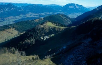
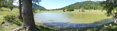
From the Feistritzer Alm pasture, the trail leads westwards for quite a while on Italian territory. It only arrives back on Austrian soil upon reaching the Starhand inn. After the dense woodland, the alpine meadows of the Dellacher Alm and the Egger Alm with the Egger Alm lake provide a welcome change.
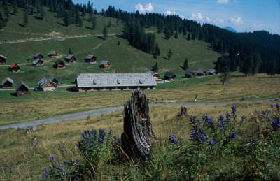
Immediately West of the Feistritzer Alm meadow, the trail leads over the Austrian-Italian border and then across alpine meadowland gently downhill to a high-altitude forest. The trail then takes a somewhat steeper downhill course in the woods to reach the Lomsattel pass, shortly afterwards reaching the Starhand inn after crossing the border once again. Follow the markings then on the road to Vorderberg for a short distance before turning left and crossing the Dolinza stream. Now head steeply uphill through woodland, later coming out onto meadowland and a spring. At a little brook, turn sharply to the right, and the trail will again swing leftward above the edge of the wood. Circumvent a grassy rounded hilltop to arrive in the pass South of the Starhand inn in just 10min. From here, the trail first runs northwards but then soon turns to the left, at which point you can already distinguish the first buildings of the Görtschacher Alm meadow (approx. 2h). From the lowest huts, follow a forest road now that leads in narrow bends into the Kesselwaldgraben rift, down to the Kesselwaldbach stream and on the other side up again until reaching the Almstrasse road after approx. 40min, which leads from the Dellacher Alm meadow to the Poludnig Alm meadow. Next, follow the Almstraße road down to the Dellacher Alm (approx. 2h from the Görtschacher Alm). From the Dellacher Alm, the road is covered in asphalt. After approx. 20min you will reach the wonderful setting of the Egger-Alm-See lake and a further 15min will take you to the Egger Alm meadow. Two alpine guesthouses offer accommodation facilities.
(Andreas Fink, Christina Schwann, OeAV Section Villach, OeAV)
Natural and cultural heritage
The district town of Hermagor is situated exactly at the point where the Gitschtal valley opens into the Gailtal valley. The town is bordered on the northern side of the valley by the Bailtal chain and on the south side by the mountains of the Carnic ridge. This protected location is undisputably one of the reasons for which the Gailtal valley was populated from a very early stage. Discoveries there have been dated as far back as the second century before Christ. Several crossings over the mountain chains such as the Plöcken pass, the Gailbergsattel pass, the Naßfeld and the Kreuzberg made trade relations possible. In the 3rd century B.C., the Illyrian population was interspersed by Celts. The Gailtal valley was thus a part of the famous Noric Kingdom, whose iron products were exported as far as the Mediterranean. The Romans tried to take the iron production for themselves; in 15 B.V., Noricum was occupied and in 45 A.D. incorporated as a province into the Roman Empire. However, the Empire was destroyed in the course of Migration Period, and the Teutons, Avars and Slavs passed through the Gailtal valley. Even today, numerous farmland names indicate the Slovenian population that continues to live in the eastern part of the Gailtal: Poludnig, Oisternig or Auernig. An insight into the history of the Gailtal valley can be gained by visiting the Gailtal local history museum in Möderndorf castle, an interesting three-storey building in the form of a cube. Hermagor was mentioned in documents for the first time as early as 1169 and the presence of pastureland is recorded in written reports. The earliest mention of the pastureland with adjoining cheese dairies comes from the rent-roll of the Count of Görz in the years 1375-1381. Furthermore, there is also a report from the year 1876 that describes pasture farming in the Gailtal valley in great detail and thus gives us a good understanding of economic relations at the time. Many of the pastures were heavily effected by events in World War I. Attempts were made to promote agricultural production using state support programmes that laid particular emphasis on mountain regions. As the Gailtal pastures were badly damaged along the front-line, some of them had to be completely restructured. In the course of the reconstruction measures, great importance was attached to the fulfilment of current demands for higher quality alpine cheese production. The alpine dairy farms then established still influence the appearance of the cultural landscape in the Gailtal today. One of these dairy farms, which is a member of the Association of the Gailtal alpine farming community, is the Egger Alm. Here, you can watch the farmers at work and even participate in the production of the famous Gailtal alpine cheese. Next to the Egger Alm, Via Alpina then moves on to other alpine farms in the association, such as the Watschiger Alm, the Treßdorfer Alm, the Rudnig Alm, the Rattenforfer Alm, the Kleinkordinalm and the Straniger Alm. All of these farms produce milk, butter and cheese directly on location and make an important contribution to the preservation of the cultural landscape. (Christina Schwann, OeAV)
Other long-distance trails and alternative routes
South alpine long-distance trail 03, KGW Carinthian border trail. The ascent of the 1,965m high Starhand and back down again takes approx. 1h and gives you a beautiful view.
Kulturweg Alpen, Band 1, Gerhard Stürzlinger ~ Pichler (ISBN 3-85431-288-1)
Kärntner Grenzweg ~ Heyn (ISBN 3-7084-0129-8)
Picture gallery
Add your own pictures!
Comments
Favourites, criticisms ? Make your personal comments on this stage. For more general notes please use the comments section of the page Over to the Via Alpinists.
Vegiwolf - 2023-09-11
Wenn Rudi einen schlechten Tag hat, kehrt man dort besser nicht ein. Wir wurden unfreundlich empfangen und das Essen war auch nicht so toll. Das Zimmer war winzig, aber sauber. Die sanitären Anlagen dürften erneuert werden.
Alternativvorschlag: Gasthaus zur alten Käserei,
Tel. +436766950660
mailto:gasthaus-zum-theo@gmx.at
flautix - 2023-08-21
Von der Dellacher Alm bis zur Egger Alm führt der offizielle Weg offenbar auf der Teerstraße... Die OpenMontainbikeMap, die ich als Hintergrund auf meiner Garmin-Uhr benutze, zeigt aber auch parallele Wege über die Almen auf, die wir lieber benutzt haben.
Halbpension im Gasthaus zum Rudi mit schönen Doppelzimmern und Duschmöglichkeit (55.- p. P.) ist sehr zu empfehlen. Hervorragendes, original kärtnerisches Essen. Rudis Kärntner Kasnudeln waren die besten auf der ganzen Tour! Das Friggapfännle ist auch sehr zu empfehlen. Sehr nette Atmosphäre!
Carsten - 2022-01-10
At signpost 'Feistritzer Alm 2 hrs' step *behind* the signpost for alternative trail directions also used by GPS coordinates Recommend not to take alternative trail (not to follow the GPS coordinates): it's a track at best, goes straight up, is overgrown in places, and blocked in steepest parts by fallen trees. Where the two trails rejoin before the Feistritzer Alm, no signpost and no paint marks on the ground indicate the alternative trail (which the GPS coordinates follow) in the reverse direction.
Lolo - 2018-08-12
Je n'ai pas pu dormir à Egger Alm...je ne sais pas pourquoi ! 2km plus loin, il y a une auberge côté autrichien et côté italien il y a le refuge Nordio Deffar tout neuf pour dormir
Automatic translation
[Google]
I could not sleep in Egger Alm ... I do not know why! 2km further, there is an inn on the Austrian side and on the Italian side there is the brand new Nordio Deffar hut for sleeping
POPEYE GG - 2018-06-13
22 juin 2017
Etape courte et simple.
En cours de route, le Rifugio Fratelli Nordio était en rénovation, donc fermé.
A Egger Alm, j'ai logé chez Rudi dans l'annexe rustique, mais il y a aussi la Sennerei à côté qui semble bien.
Attention, accessible en voiture, donc il peut y avoir du monde.
Automatic translation
[Google]
June 22, 2017 Short and simple step. Along the way, the Rifugio Fratelli Nordio was under renovation, so closed. At Egger Alm, I stayed at Rudi's in the rustic annex, but there is also the Sennerei next door that looks good. Attention, accessible by car, so it can be crowded.
I warmly recommended staying at Wirtshaus Starhand. People are truly friendly and funny. I camped at the (old) cheese-making-place, but I have to say that I regret not having dinner and breakfast in the hut. It looked delicious and as the other guests said, it has been the best they had... The path through the forest was a bit damaged because of a storm earlier in August, but it's well marked. If you come from Görtschacher Alm, pay attention, don't take the most obvious path on the right, but you have to hike a bit uphill to get to Starhand. Between Dellacher Alm and Görtschacher Alm, I missed the hiking path and hiked the forest road.
Tof - 2014-10-28
Trieste Monaco, 09/07/2014
Au gasthof Rudi possibilité d'hébergement dans un gite annexe en dortoir pour 25 euros (nuit + petit déjeuner). La patronne fut très serviable. A emmené l'un de nous en vallée (8kms) pour retirer du cash.
Ravitaillement en excellent fromage d'alpage à l'auberge voisine (E.Buchacher), très bon marché. Viande également disponible à la vente.
Automatic translation
[Google]
Trieste Monaco, 09/07/2014 In gasthof Rudi possibility of accommodation in an adjoining cottage dorm for 25 euros (night + breakfast). The boss was very helpful. A took one of us in the valley (8km) to withdraw cash. Refueling great mountain cheese at the nearby inn (E.Buchacher), very cheap. Meat also available for sale.
Via Alpina international secretariat - 2014-04-02
The renovated Oisternig hut will be open again this summer from May to October!
Demmeljoch? - 2013-09-08
Falls man, wie ich, die Variante über die Poludnig-Alm wählt: Ein Weg führt von der untersten Poludnig-Alm zunächst nach Osten (408) Richtung Dellacher Alm, zweigt aber nach ca. 15 Min nach links ab Richtung Eggeralm. Östlich des Eggeralmsees kommt man wieder auf Weg 403 (Original Via Alpina)
Automatic translation
[Google]
If you, like me, choose the type using Poludnig Alm: A path leads from the lowest Poludnig Alm first to the east (408) direction Dellacher pasture, but branches off after about 15 minutes left towards Eggeralm. East of Eggeralmsees to get back on route 403 (original Via Alpina)
Demmeljoch? - 2013-09-08
Bei der Göriacher Alm muss man gut aufpassen, tatsächlich den Weg von der untersten Alm zu nehmen. Weiter oben gibt es eine Forststr. die in meiner Karte nicht eingezeichnet war (Freytag und Bernd). Bei der Göriacher Alm tendenziell immer links halten. Es geht ziemlich nach unten. Derzeit Forststrassenarbeiten. Via Alpina ist meist nur mit der rot weiß roten Markierung gezeichnet (fast keine Wegweiser). Am Talgrund führt sie ziemlich unwegsam runter zum Kesselwaldbach und ähnlich unwegsam auf der anderen Seite wieder bis zur asphaltierten Straße.
Automatic translation
[Google]
When you have to take good care Göriacher Alm to actually take the path of the lowest Alm. Further up there is a Forststr. which was not shown in my map (Freytag and Bernd). Keep left tends When Göriacher Alm. It's pretty down. At present forest road work. Via Alpina is usually only with the red-white-red mark drawn (almost no signpost). At the bottom of the valley it leads quite impassable down to the boiler Waldbach and similar impassable on the other side to the paved road.
Elisabeth - 2012-11-30
Après Dellacher Alm, un itinéraire permet d'éviter la route : le sentier passe en rive gauche du lac Egger Alm.
Automatic translation
[Google]
After Dellacher Alm, a route avoiding the road: the path goes left bank of Lake Egger Alm.
If you are eastbound, this is the start of the bear area, up until deep into Slovenia! The west-bound hikers safely can unload their rifles now! When I was in Feistritzer Alm, two sheep were killed by a bear the week before. During my dinner the farmer told me in detail how the sheep had been ripped apart!
Alpinisten - 2011-09-07
Auf der Deglacier Alm kann man im "Almgasthaus Pipp" auch schon einkehren (keine Übernachtung).
Automatic translation
[Google]
On the Deglacier Alm can be seen in "Almgasthaus Pipp" already come (no overnight).
ROUSSELLE - 2010-01-06
Après Wirtshaus Starhand, un sentier bien balisé monte au Col du Kopjsica (1852m). Là en 2008, il n'y avait plus de balisage. Partir à droite puis descendre jusqu'à la piste à 1400m d'altitude. Comme le sentier indiqué sur la carte n'existe plus,suivre la piste qui contourne le vallon à gauche (quelques balises VA) et monte à flanc du Mont Poludnisk avant de redescendre sur Dolska.
Automatic translation
[Google]
After Wirtshaus Starhand a well-marked trail climbs the Col du Kopjsica (1852m). There in 2008, there were more signs. From right then down to the track at 1400m. As the path shown on the map no longer exists, follow the trail that skirts the valley to the left (a few beacons VA) and up the side of Mount Poludnisk before descending Dolska.

 |
3h50 |
15.3 km
|
580 m
|
876 m
|
3h50 |
15.3 km
|
580 m
|
876 m


Favourites, criticisms ? Make your personal comments on this stage. For more general notes please use the comments section of the page Over to the Via Alpinists.