Hiking (mountain trail, in places narrow and exposed)
Alpine route (equipped or very exposed section, snow field, blocks)
R10a
Črna prst » Rjava skala
|
5h00 |
12.2 km
|
239 m
|
529 m
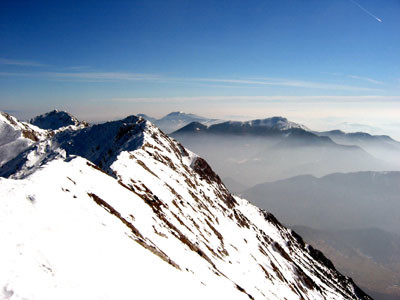
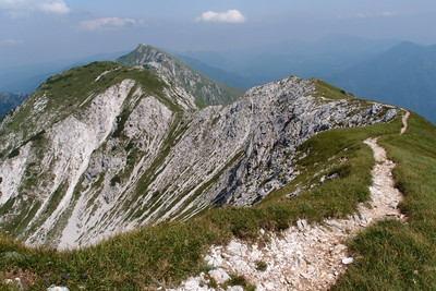
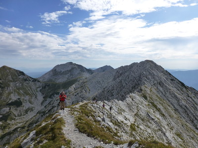
This stage provides magnificent views of the Julian Alps and Lake Bohinj. For its most part it follows the ridge that connects the Lower Bohinj mountains, climbing the Rodica peak known for its rich flora and then the Šija peak. At the end the route descends to the top station of the cable car of the Vogel ski resort. Despite always staying around 2000m height, the tour doesn’t require any technical skills but it is very exposed and calls for a sure foot. It should not be walked in foggy or rainy conditions.
For most of this stage, you will hike west along on the ridge of the Lower Bohinj mountains. At first, you will have to descend down a rather broad ridge, which becomes increasingly narrower. The pleasant part of the walk on the ridge soon comes to an end and you will have to climb up the western part of Črna prst to the Vrata gap (1,721 m). On the other side, climb up the steep and grassy slope below the peak of Četrt (1,832 m), where the narrow track begins levelling out and cuts across the steep, grassy slopes. The path crosses a ridge and brings you to the pass between the peaks of Poljanski vrh and Matajurski vrh. Continue walking along the ridge. Cross a rocky section then walk along the relatively flat path below the main ridge and past Matajurski vrh to your left. 1h 45 minutes. At the grassy shoulder, you will cross over into the Primorska region. You will bypass the peak of Raskovec (1,967 m) by way of the southern part of the ridge. You will reach the ridge again after passing through the saddle between Rodica and Veliki Raskovec. Continue walking in the direction of the ridge, moving from one side of the ridge to the other several times. The narrow and steep ridge leads all the way up to the peak of Rodica (1,966 m). 45 minutes. From Rodica, continue walking along the ridge. Walk down the gentle slope to the foot of Rodica, then up a slight incline to a level ridge. Descend again down the side of the wide meadow to the Čez Suho pass (1,773 m), where you will meet the taril from Ribčev Laz in the valley. There will be another short climb before the descent down the northern face of the ridge to the pass below the conspicuous peak of Šija (1,880 m). 1h 45 minutes. To the right is Visoki Orlov rob peak (1,800 m), which is accessible by chair lift from the Vogel ski slopes. As the stage is a very long one, this would be a suitable place to take a break. Follow the marked path across Visoki Orlov rob to the Vogel Ski Hotel (45 minutes). This stage will take approximately 5h.
Source: Dobnik, Jože; (1998). Slovenska planinska pot. Planinski vodnik. Založba: PZS. Mihelič, Tine; (1998). Julijske Alpe. Planinski vodnik. Planinska zveza Slovenije. Ljubljana: Založba PZS. Atlas Slovenije. (1996). 3. izpopolnjena in razširjena izdaja. Ljubljana: Mladinska knjiga in Geodetski zavod Slovenije. Julijske Alpe - vzhodni del. (2003). 1:50.000. GZS. Ljubljana: Planinska založba (PZS). Škofjeloško in Cerkljansko hribovje. (1993). Izletniška karta. 1:50.000. Ljubljana: GZS. (Peter Šilak)
Natural and cultural heritage
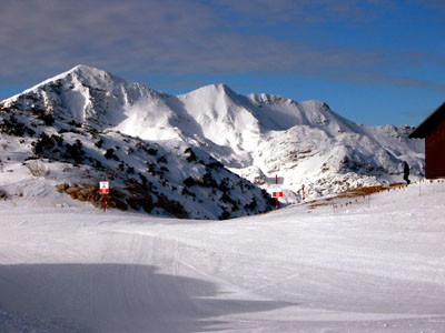
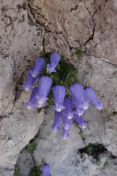
A ridge links the peaks of Črna prst, Rodica, Vogel and Veliki Bogatin and rises steeply between Baška grapa and Bohinj. This mountain chain is known as the Lower Bohinj Mountains. The most popular of the peaks is Črna prst (1,844 m) because of the abundance of flora there. The wide variety of plants has been drawing botanists for the last two centuries. In 1833, chemist and pharmacist Žiga Graf discovered the Pedicularis hacquetii, named after Baltazar Hacquet, a renowned natural scientist from Idrija. Other botanical species that should not be overlooked are Gentiana lutea, Geranium argenteum and Eryngium alpinum. Črna prst (Black Earth) was named after the black slate found near the peak. The Adriatic Sea can be seen to the south of the Lower Bohinj Mountains whilst Triglav can be seen to the north. Triglav is the tallest mountain in Slovenia, standing out from the other peaks in the Julian Alps. In the glacial valley below lies Lake Bohinj, the biggest natural lake in Slovenia. The lake is 4,100 m long, 1,200 m wide and 45 m deep. Water flows into the lake mainly from the Savica waterfall to the west. Remains of border stones, bunkers, trenches, etc., marking the border between the Kingdom of Italy and the Kingdom of the Serbs, Croats and Slovenes are scattered along the ridge. According to the Treaty of Rapallo signed in 1920, Primorska fell under Italian jurisdiction. Vogel (1,922 m) is the name of a peak as well as of the Karstic plateau that climbs from an altitude of 575 m to 1,800 m. A cableway runs from the valley below to the Ski Hotel and ski slopes on the plateau. To the south-west of the Ski Hotel is the Lopata forest reserve, on of the few remaining virgin forest in the Julian Alps. The forest lies at the juncture between the cold Alpine and warm Mediterranean climates. Due to this phenomenon, a variety of flora can be found here, including picturesque old trees overgrown with fungi. The poorly maintained path through the reservation was built in 1988. Habjan, V.; Skoberne, P. (2001). Naravne znamenitosti Slovenije. Ljubljana. Cerar Drašler, I. (2004). Pravljične poti Slovenije. Ljubljana. (Jerneja Fridl)
Useful topographic maps
Julijske Alpe, vzhodni del ~ Planinska zveza Slovenije (1 : 50 000)
Gorenjska ~ Geodetski zavod Slovenije (1 : 50 000)
Bohinjsko jezero z okolico ~ Planinska zveza Slovenije (1 : 25 000)
Useful guidebooks
Slovenska planinska pot ~ Planinska zveza Slovenije (ISBN 961-6156-11-x)
Vodnik po Julijskih Alpah ~ Planinska zveza Slovenije (ISBN 961-6156-08-x)
Vodnik po planinskih postojankah v Sloveniji ~ Planinska zveza Slovenije (ISBN 961-6156-10-1)
Websites relative to natural and cultural heritage
Favourites, criticisms ? Make your personal comments on this stage. For more general notes please use the comments section of the page Over to the Via Alpinists.
Vegiwölfe - 2023-09-16
Wir fanden Chalet Burja ganz ok. Das Zimmer mit Dusche/Bad war sauber und für müde Wander/innen genügend. Das Wirtepaar hat sich extrem viel Mühe gegeben und war äusserst hilfsbereit.
Der Abstieg vom šija nach Rjava skala wurde durch die Skipisten extrem verunstaltet. Sehr schade!
M&M - 2023-09-10
Chalet Zala ist ab September geschlossen. Ski-Inn Burja ist leider auch nicht uneingeschränkt zu empfehlen. Möglicherweise ist es eine Alternative, mit der Seilbahn nach Ukanc für die Übernachtung zu fahren.
flautix - 2023-08-26
Der auf Komoot angegebene Track gibt zwar die Route wieder, hat aber gravierende Fehler: er führt an mehreren Stellen hin und zurück, weshalb die angegebenen Kilometer- und Höhenangaben schlicht falsch und absolut überzogen sind. Ich biete hier meinen Track als Alternative an:
komoot.de/tour/1270694242?ref=wtd&share_token=ahA13ACbVVN1Bhaf77iYNmmilef7zsUZEVRga65zDmb2ytLpu8
flautix - 2023-08-20
Wir waren leider bei den Unwettern im August hier... Vor dem Start habe ich die Wetterlage mit unserem Hüttenwirt besprochen: eigentlich sollte ein Regenloch kommen und Gewitter waren erst für den Nachmittag angekündigt. Schwierige Wege im Regen sind wir halbwegs gewohnt. Leider kam keine Regenpause - dafür um 10 Uhr, als wir auf dem Kammweg halbwegs waren, ein Gewitter. Viel Platz zum Schutz suchen war leider nicht: wir duckten uns an einer kleinen Felswand, aber der Regen und schließlich Hagel kamen genau von der anderen Seite... Danach kam wirklich eine kurze Regenpause und es riss etwas auf, so dass wir zeitweise sehen konnten, wo wir hier herumlaufen. Wirklich kein guter Weg bei schlechtem Wetter! Einige ausgesetzte Stellen, die Schwindelfreiheit erfordern. Dafür viele Edelweiß!
Bei schönem Wetter sollte man überlegen, ob man den Umweg nach Rjava Skala macht oder einfach auf der Höhe weiterläuft und dann zur Dom na Komni absteigt. Chalet Zala können wir nicht empfehlen!
Anne - 2023-07-20
Stayed at Chalet Zala in Rjava Skala. Found it on booking.com. But next time i would rather call, it could be cheaper. It was okay. With shower. It belongs to chalet burja which has rooms as well. I guess more expensive ones.
Ingo - 2022-09-17
Concerning Carstens post for R10 (A and B) we can inform that the last 2km are not overgrown anymore. Bushes have been cut recently. So thanks to cutting, it´s not unpleasant anymore.
Karsten - 2022-07-04
As mentioned by Carsten below: water is scarce. I filled up my waterbottles at Crna Prst (they have great pasta) at the faucet (rain water from the roof), using my Micropur for purification. Did work out well.
Great hiking with a little bit of "4x4". Skipped the go-and-return to Rjava skala and contrinued on to Domna Komni. In case of bad wheather I would have crossed over to Bivak Globoko (after Vogel) or descended to Planina Razor on the southern side.
Carsten - 2022-01-10
R10 (A and B)
Spectacular ridge and highline walk; highly unpleasant last 2 km of overgrown Karst landscape (can be avoided by continuing on the current good trail to [hut] Loca Pod Bogatinum which then connects directly to about 2km into R11)
No water. (Faucet with sign non-potable a few steps down from the hut at the beginning of R10.)
No good camping possibilities. A few/poor possibilities in second half of R10A (beware of fierce winds along ridge), and one occasion perhaps two-thirds into R10B. No camping possibility in Karst area at end of R10B.
A bulky backpack could be a hindrance in some delicate passages of R10, which tend to come with overhanging rocks or shrubs. Backpack weight should be stable and close to the body.
Hundreds of tourists walk up Šija mountain at the transition from 10A to 10B (not part of 10A or B).
A 1.5l water bottle costs Euro 4.40 at the hut at the end of R10B. The hut is a big building that has many 2-bed rooms. No shower.
kessel_kolumna - 2020-07-10
Wegen Corona konnten wir im Skigebiet Vogel erst keine Unterkunft buchen. Wir haben dann umgeplant und haben im Tal in Ukanc gebucht. Es ist möglich, runter zu laufen, aber es fährt auch eine Gondel von 8 bis 18 Uhr. Der Bohinj-See ist aus der Nähe ebenfalls wunderschön. Als Unterkunft können wir die Apartments Ukanc mit angeschlossener Pizzeria nur empfehlen. Das Abendessen war super und das Frühstück ein Traum!
POPEYE GG - 2018-06-13
16 juin 2017
Etape avec des paysages sublimes! Mais elle est assez accidentée et il vaut mieux la faire par beau temps, ce qui fut heureusement le cas (voir aussi mon blog "vivelaretraitesurlaviaalpina.blogspot.com", étape 9).
J'ai eu la chance de la faire en compagnie de 3 Slovènes dont l'un parlait parfaitement l'allemand; il m'a dit que la fin de cette étape ne présentait pas d'intérêt, qu'on avait une vue sur les installations de descente de ski, qu'il valait mieux monter au Vogel et descendre sur la gauche à 500m en contrebas jusqu'au refuge Koca na Planini Razor où eux-mêmes avaient réservé, ce qui a été une chance pour moi, puisqu'on sait jamais à l'avance si le refuge sera ouvert ou non... et réserver en langue slovène, pas évident, comme je l'ai mentionné déjà!
Un orage était annoncé et est survenu vers 14-15h, heureusement que nous étions tous arrivés au refuge!
Ici aussi, pas d'eau potable, mais on peut se laver à l'intérieur.
Automatic translation
[Google]
June 16, 2017 Step with sublime landscapes! But it is quite rugged and it is better to do it in good weather, which was fortunately the case (see also my blog "vivelaretraitesurlaviaalpina.blogspot.com", step 9). I was fortunate to do it in the company of 3 Slovenians, one of whom spoke perfect German; he told me that the end of this stage was not interesting, that we had a view of the ski descent facilities, that it was better to go up to the Vogel and go down on the left at 500m down to to the Koca na Planini Razor hut where they themselves had booked, which was a chance for me, since we never know in advance if the hut will be open or not ... and book in Slovene language, not obvious as I already mentioned! A thunderstorm was announced and came around 14-15h, fortunately we had all arrived at the shelter! Here too, no drinking water, but you can wash inside.
There is a bad weather alternative: the E7 from Razor to Petrovo Brdo 29km, but not to much altitude difference. Actually it's a real nice balcony trail through the forest. In Stržišče or Kal, it's also possible to go up to Črna prst (2,5hours).
delbende - 2016-11-02
A Vogel, le refuge Planinska koča Merjasec et les 2 auberges sont fermés à partir d'octobre. Il faut prendre la benne qui descend dans la vallée à Ukanc (la gare est à coté du ski hôtel Vogel dernière à 18 h cout : 6 euros) ou descendre à pied (1h30).
Bruno et Véronique 10/2016
Automatic translation
[Google]
In Vogel, the Planinska koča Merjasec hut and the 2 hostels are closed from October. It is necessary to take the bucket which goes down in the valley with Ukanc (the station is next to the ski hotel Vogel last at 18 h cost: 6 euros) or to go down on foot (1h30). Bruno and Véronique 10/2016
Riccardo Del Re - 2016-01-04
Challenging stage, sometimes easy, in other parts very exposed and dangerous . It requires a minimum of experience and preparation because it is not supported by cables . Very dangerous with fog or wet rock .
Need additional metal wires in the stretch Matajurski Vrh - Rodica .
Exceptional view from the top of Mount Rodica.
Wonderful welcome to Rjava Skala , shower and pleasant rooms .
(we walked on it in August, good period)
Tentorini Chantal - 2015-09-24
Je suis redescendue sur Vogel pour me loger en télésiège (A/R 4 €).
Automatic translation
[Google]
I went back to house Vogel me chairlift (A / R € 4).
Jean-Pierre G. - 2015-07-28
The stage between Čnra prst and Dom na Komni might offer spectacular views and other alpine thrills. However some trail-sections are extremely exposed and dangerous to cross, especially with rain and fog and/or heavy backpacks. In our opinion some of them should definitely be secured with cables. We decided to turn back after encountering the third commemorative plaque for fallen victims within the first hour of hiking. As an alternative we chose to descend through the woods to Bohinjska Bistrica, cross over to lake Bihinsjsko (great swimming) and climb up again at the end of the valley to pick up the trail again at Dom na Komni. Additional fringe-benefit : In Bistrica you can wash your clothes at the local camping-site.
tof - 2014-10-27
Monaco-trieste, 23/06/2014.
Etape longue avec nombreux névés dont certains sont délicats, petits crampons utiles. Sur la fin le balisage est sous la neige: +1heure. Total: 12 heures.Etape qui reste magnifique.
Arrêt intermédiaire à Razor semble une bonne option.
Très bon accueil à Dom Na Komni.
Automatic translation
[Google]
Monaco-Trieste, 23.06.2014. Long stage with many snowfields, some of which are delicate, small spikes helpful. In the end the markup is in the snow: + 1 hour. Total: 12 heures.Etape remains beautiful. Intermediate stop at Razor seems like a good option. Very welcome Dom Na Komni.
Pasquet - 2014-09-12
Cette étape est longue et si l'on veut la couper en deux, sachez que le SkiHotel de Vogel est fermé.
L'entrée sur l'espace de ski est d'ailleur très déplaisant (terrain abîmé, bruit de terrassement...). Pour couper l'étape en deux, nous avons passé le col de Globoko et sommes allé au refuge de Razor où l'accuiel est très chaleureux. Le chemin est facile et bien tracé, malgré le dénivellé important.
Automatic translation
[Google]
This step is long and if we want to cut it in half, you know that Skihotel Vogel is closed. The entrance to the ski area is btw very unpleasant (land damaged noise-moving ...). To cut step two, we spent the neck Globoko and we went to the shelter where accuiel Razor is very warm. The path is well marked and easy, despite the significant height difference.
Via Alpina International Secretariat - 2013-01-14
Warning: we are currently updating the data from this stage to split R10 into two shorter stages. In the meanwhile contact the Slovenian national secretary at info@hiking.si for information.
DanielTed - 2012-12-05
Magnifique étape, partis avec un peu de brouillard, ensuite soleil de septembre... boisson fraîches bienvenue à l'arrivée au refuge de Domna Kommi
Automatic translation
[Google]
Beautiful stage left with a bit of fog, then sunny September ... welcome on arrival at the shelter cool drink Domna kommi
Elisabeth - 2012-11-30
Temps de marche et difficulté sous-estimés : sentier étroit souvent exposé. Il faut vraiment aller doucement quand on a un gros sac - je pense qu'il faut compter 1h de plus. Au col Konjsko sedlo, bien descendre sur la droite (plus de poteau indicateur !) - ne pas prendre le sentier qui continue en face. Le refuge Domna Komni est super !
Automatic translation
[Google]
Running time and difficulty underestimated: narrow path often exposed. You really need to go slowly when you have a big bag - I think it takes 1 hour more. Collar Konjsko sedlo, well down on the right (signpost!) - Do not take the path that continues in the face. The shelter is super Domna Komni
The R10 can be done in one day, leave early. It took me 8 hours! However, it is by far the hardest stage in the Slovenian part. The first part, from Crna Prst to Sija can be rated difficult and at many places dangerous. The track is small and on one (sometimes two) sides a slope goes steeply down 100's of meters. Do this part only in good condition, perfect equipment, and good weather. Don't go alone.
Sija to Plese is just hard, and at some places difficult. It is mainly a track with loose rocks. From Plese to Komni the track goes through low bushes, and only goes a little up and down. Take plenty of water, because there is nothing underway. I consumed 2 liters on this stage.
Alpinisten - 2011-09-08
Das Skihotel Vogel hat im Sommer 2011 geschlossen wegen Renovierung...
Automatic translation
[Google]
This ski bird has closed in summer 2011 for renovation ...
Alpinisten - 2011-09-08
Achtung, diese Etappe wird laut Hüttenwirt mit 10h angesetzt! Wegen dichtem Nebel mußten wir leider absteigen nach Podbrdo und sind dann mit dem Autoreisezug um 11 Uhr nach Bohinjsko Jezeroh gefahren. Es gibt dort ein kleines Passagierabteil und die Fahrt dauert nur 10 Minuten durch den Tunnel. Vom direkten Abstieg auf die nördliche Seite riet man uns ab. Die Wege sind wohl in keinem guten Zustand und zu selten begangen.Von dort ging es dann problemlos weiter Richtung Dom na Komni bzw. Triglav.
Automatic translation
[Google]
Note that this stage is set according to landlord with 10h! Due to heavy fog, we unfortunately had to dismount to the Apparition Hill and then drove the car train at 11 clock after Bohinjsko Jezeroh. There is a small passenger compartment and the trip takes 10 minutes through the tunnel. By direct descent on the northern side was advised from us. The roads are probably not in good condition and rarely begangen.Von there it went smoothly on towards Dom na Komni or Triglav.
vohi - 2010-09-01
Crna Prst: Einziges Manko: Wassermangel (Ende August) / keine Duschgelegenheit!
Automatic translation
[Google]
Crna Prst: The only drawback: lack of water (end of August) / no shower facilities!
vohi - 2010-09-01
Route ist kurz vor Crna prst relativ gefährlich (fällt neben Grat steil ab), besonders weil man davor schon so lang gelaufen ist und nicht mehr so viel Kraft hat.
Sie ist aber an einem Tag gut gehbar! Haben etwa 7h30min dafür gebraucht!
Die Hütte Crna Prst ist sehr empfehlenswert, sehr nette Gastgeber, sehr preiswert, bestes Frühstück und einen wunderschönen Ausblick am Abend/Morgen
Automatic translation
[Google]
Route is prst shortly before Crna relatively dangerous (next ridge falls steeply), especially because you went in front for so long and no longer has so much power.
But it is good foot traffic in a day! Have about 7h30min used for that!
The cabin Crna Prst is highly recommended, very nice hosts, great value, best breakfast and a beautiful view in the evening / morning
Charles - 2010-08-21
Same warning about the steep ravines on both sides (easter section). Some of these places should be equipped. Extra care shall be taken when walking with heavy bags. Hwever the scenes worth it !
marjan Vermeulen - 2010-07-26
The information about this stage R10 from ‘dom na Komni to crna prst’ is not adequate. From the information on the internet you get the impression that it is very well possible to walk this in 9.05 hours. No hint is given that the stage should be walked in two days (as we did by staying the night at the cabin near de Vogel ski hotel, as is suggested in the information given in the information reverse direction (see text below). To walk this in one day is madness because the stage has some very difficult pieces even for experienced walkers.
Coming from Dom na Komni, first there is a part that is not well kept, the bushes grow over the path, it is not dangerous but it takes more energy and time than expected. A great deal of the whole path needs a lot of concentration in order not to make a fatal misstep on the steep slopes. Besides that, there are parts where you need both your hands to climb over rockets. Especially after the climbing of the top ‘Rodica’ you walk on a very steep slope, where sometimes almost no path exist and some of the parts are better known in Italia as ‘via ferrata’. Once your on this part, there are no alternative ways to get of the ridge, till about half an hour for you reach the cabin.
In our experience this stage is not (as the information says) ‘easy’, you need a lot of concentration to finish this in good health, even if you do it in two days and with good weather.
Before us was a group of 10 people walking who try to do it in one day, they thought it was possible. Unfortunately one of them got a deadly accident after about 10 hours walking and never made it.
Internet text r10( reverse directrion): This long stage can be shortened by a detour and an overnight stay at the Ski Hotel. There are magnificent views of the Julian Alps and Lake Bohinj. Much of the route follows the ridge connecting the Lower Bohinj mountains. Although the tour is at an altitude of about 2,000m, the hike is EASY and pleasant. It ends on the spacious Komna plateau, a winter paradise for ski-mountaineers
pixelator30 - 2010-07-14
Also, as much of the eastern section of this trail is on a ridge, watch out for any thunderstorms. If you see one brewing near you, get off the ridge before heavy rain, or else you risk being hit by lightning.
pixelator30 - 2010-07-14
Just a tiny bit of warning: This trail is indeed for the most part easy, however, much of the eastern section rides on a rather narrow mountain ridge, with steep slopes to either side. Nothing too difficult - but care must be taken in case of fog or rain when the rock is wet - can be slippery.

 |
5h00 |
12.2 km
|
239 m
|
529 m
|
5h00 |
12.2 km
|
239 m
|
529 m


Favourites, criticisms ? Make your personal comments on this stage. For more general notes please use the comments section of the page Over to the Via Alpinists.