Hiking (mountain trail, in places narrow and exposed)
Alpine route (equipped or very exposed section, snow field, blocks)
D16
S. Antonio di Valvogna » Gressoney-Saint-Jean
|
6h05 |
12.5 km
|
1592 m
|
1587 m
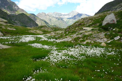
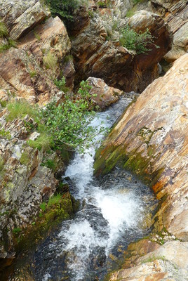
From Sant'Antonio the trail follows the stream upwards through Vogna valley, turning aside later towards the Alpe Larecchio pasture. It then leads to the Valdobbia pass and the Ospizio Sottile hut. The pass leads into Aosta Valley via an old merchant route. Through pastures and a protected area, thick with plant and animal life, the trail then descends to the valley floor and Gressoney-Saint-Jean.
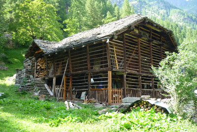
From Sant'Antonio a broad track, which quickly becomes a bridleway, follows the bottom of the Vogna valley until the fork to Alpe Larecchio. A point of interest along the way is the Napoleonic bridge and the Alpe Peccia church which has just been renovated. A short detour from the main trail leads to Alpe Larecchio and the Alpe Larecchio agriturismo restaurant. From there to the Valdobbia pass the trail is wide and clear. The Ospizio Sottile hut is at the Valdobbia pass. The Valdobbia pass is on the top of the ridge between the Valsesia and Gressoney valleys. In centuries past, this was the route for the essential seasonal migration from Valsesia and from the Piedmont and Lombardy regions to the markets of Geneva and Lyon. In order to avoid the numerous accidents that took place every winter, in 1823 Canon Nicolao Sottile built the hostel on the very summit of the pass, also furnishing it with meteorological instruments. The hut has recently been renovated and it reopened in the summer of 2002. From the pass, the trail heads down through pastures, encountering a rich oasis of alpine wildlife. After a series of tight bends the trail leads to the tiny village of Verdebio. It is signposted 105 and 11. Climb the road that runs parallel to the stream and after 20 minutes or so it leads to Gressoney- Saint-Jean. (Regione Piemonte)
Natural and cultural heritage
Gressoney-Saint-Jean is the most important administrative area in the Lys valley (Lys is the name of the stream that runs through the valley). It is a famous summer and winter resort. It was founded back in the 13th century by shepherds from the Valais region in Switzerland. The historic centre is typical of the region, with the old Walser houses grouped around the church of San Giovanni, rebuilt in 1725 on the foundations of a 6th century church. Outside there is a remarkable 17th century portico with chapels covered in frescoes that were once part of the cemetery and inside there is a splendid 13th century triumphal crucifix, one of the oldest in Aosta Valley. In the green woods, set apart from the village, is the Castel Savoia castle (1904), built by queen Margherita who loved to spend her summers in Aosta Valley and, from 1889, was a regular visitor to Gressoney-Saint-Jean for her summer holidays. The regional museum of Alpine fauna (Loc. Predeloasch, 9 tel. +39 0125 355406) is worth a visit. The building dates back to 1902 and houses the collections of hunting trophies, old weaponry and precious family heirlooms such as pictures, portraits, books and publications on Alpine flora and fauna which Baron Luigi Beck Peccoz donated to Gressoney-Saint-Jean, his family’s ancestral village. Next to the museum is Villa Margherita, an outstanding example of late 19th century Bavarian architecture, today the town hall. During the summer there is a rich calendar of events, known as the Gressoney Walser Festival. On 24th June, the feast of the patron saint San Giovanni takes place. It is one of the few occasions during which the elegant costume of the local women can be admired. It is red and black, with a richly embroidered white blouse and a precious cap, embroidered in gold thread. (Regione Piemonte)
Other long-distance trails and alternative routes
Part of the trail follows the route of GTA stage 238.
Useful topographic maps
10 ~ IGC Monte Rosa (1: 50.000)
84 ~ KOMPASS Mont Rosa (1: 50.000)
294 ~ CNS Mischabel (1: 50.000)
Useful guidebooks
Monte Rosa, G.Buscaini ~ CAI-TCI (ISBN 1991)
Camminaitalia, Cannobini, Carnovalini, Valsesia ~ le guide di Airone, Mondadori (ISBN 1995)
Guida itinerari escursionistici della Valsesia, vol.IV ~ CAI Varallo (ISBN 2003)
Guida n°3-Le valli del Monte Rosa ~ Le guide dell'escursionista (ISBN )
Websites relative to natural and cultural heritage
Favourites, criticisms ? Make your personal comments on this stage. For more general notes please use the comments section of the page Over to the Via Alpinists.
FX - 2023-09-28
Itinéraire réalisé de Riale (D1) à MontCenis (D34) du 19/08 au 12/09/23.
Nous avons emprunté un autre itinéraire plus alpin à la place de la D15 et D16, pour une plus jolie vue sur les Monte Rosa, qui traverse depuis Alagna jusqu'à Gressoney-la-Trinté puis Gressoney St Jean, par le Passo Foric puis Zube (étape longue et physique mais plusieurs refuges sur le parcours la rende segmentable).
Cf. https://www.openrunner.com/route-details/17539860

 |
6h05 |
12.5 km
|
1592 m
|
1587 m
|
6h05 |
12.5 km
|
1592 m
|
1587 m


Favourites, criticisms ? Make your personal comments on this stage. For more general notes please use the comments section of the page Over to the Via Alpinists.