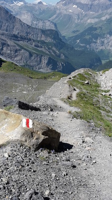
Hiking (mountain trail, in places narrow and exposed)
Alpine route (equipped or very exposed section, snow field, blocks)
C12
Griesalp » Kandersteg
|
7h10 |
14.5 km
|
1333 m
|
1582 m
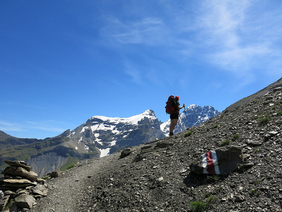
Leave the Griesalp heading southward and climb up past the Bundalp to the Hohtürli pass, the highest point on the Via Alpina trail through Switzerland. Below the Blüemlisalp glacier, walk down to the Öschinensee lake. Follow its outlet - the Öschinenbach stream to reach Kandersteg, the stage destination.
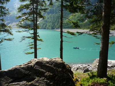
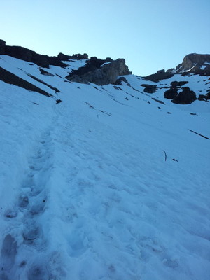
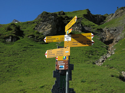
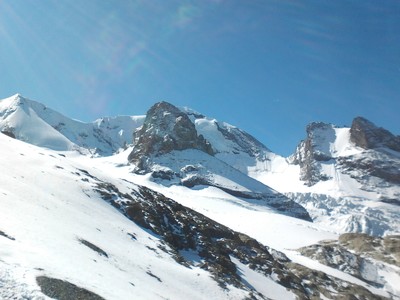
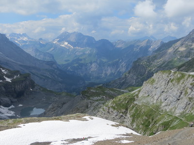
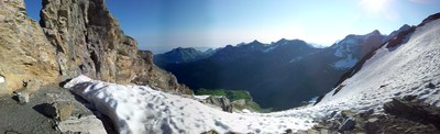
From the Gries Alp, first walk through the wood and then across meadows to the hut above Bundstäg. The trail leads in many hairpin bends up through woodland to the Underi Bundalp huts and on across meadows on the left-hand side of the stream to Oberi Bundalp, where a beautiful view into the Kiental valley and over to the Sefinenfurgge pass invites you to linger for a while. Above the alpine dairy huts, cross the Bundbach stream and climb to the Bundläger area. The trail leads uphill on a pastureland ridge to Schnattweng. Here, it heads over boulder-strewn slopes into a gully. At the foot of a long ledge, the trail winds its way up into the Hohtürli gap. The Blüemlis alpine hut of the SAC (Swiss Alpine Club) is located about 60m higher up. The ice-plated Morgenhorn, Wyssi Frau and Blüemlisalphorn summits appear to be almost within reach, with the neighbouring Wildi Frau, Stock and Rothorn seeming to form a bulwark. The heavily scratched Blüemslialp glacier stretches over their mighty flanks down into the immediate vicinity of the pass. From the Hohtürli, a trail leads to the right across the boulder-strewn slopes of the Schwarzhorn peak down to the extensive side moraine of the Blüemlisalp glacier. The blue Oeschinensee lake is already winking far below. From the moraine end of a ledge, head down to the Oberbärgli huts. First walk across the meadow and then over rocky sections – the trail is secured with steel ropes in particularly exposed places – to reach Unterbärgli. Then continue through sparse mountain woodland past wildly romantic rocky ledges to the Oeschinensee lake. It owes its existence to a rock fall from the Doldenhorn. The masses of scree at the time formed a wall in the western valley basin, blocking the water rushing down from the rock faces. Its outlet is subterranean and only emerges from the earth 400m further down in the valley. From there, it surges as the Öschibach stream to the Kander river. At the west side of the lake, a little further up, there are several guesthouses in Lägern. A chair lift about 1.5km west of Lägern leads to Kandersteg. From the Oeschinensee lake, well-built trails to the left and right of the Öschinenbach stream lead down to the valley floor and on along the road through the village to Kandersteg train station. (Schweizer Wanderwege)
Natural and cultural heritage
Blüemlisalp legend Where today the glaciers of the Blüemlis Alp stretch out as far as the Hohtürli pass crossing, there used to be a glorious alpine meadow. It belonged to a young alpine dairy farmer who moved to the mountain each summer with his farmhands and a large herd. The lush meadows were so fertile that the cows could be milked up to three times a day. One day, the farmer married a young woman who proved to be his undoing. In order for her to avoid walking over the hard stones, for example, he had to build a stairway made from cheese loaves from the hut to the cheese storehouse, pave it with butter and each day rinse it clean with milk. When the dairy farmer’s old mother learned of this wicked behaviour, she started out along the road to rebuke her son. Exhausted and thirsty, she finally arrived at the hut. When she asked for a drink of milk, the hardhearted son, influenced by the laughter of his wife, only gave her a “Kachel Schotte” (mug of whey). Her only reward for the well-meaning words of admonishment were scorn from both. The outraged mother started out along the homeward journey. Before leaving, she turned around once more and cursed the alp, wishing it to be submerged in the eternal ice. Scarcely had she moved away than part of the glacier broke off from the mountain, falling over the lush meadowland and burying huts, people and cows under the mighty ice and firn masses. To this day, it is said that at certain times the howls of the wicked son and the bellowing of the cows can still be heard. Kandersteg Kandersteg is situated on a wind-protected terrace of the Kandertal valley. A footbridge leading over the Kander gave the village its name. Discoveries from the Bronze Age would suggest that this place was already known as a starting point for the Gemmi and Lötschen passes. In the Middle Ages, the Lötschen pass gained a certain level of significance as a trade route, as cattle were driven over it into the Wallis region, from where cheaper salt was transported in the opposite direction. At that time, Kandersteg belonged to the Lordship of Frutigen. In the year 1400, the Lords of Thun who resided in Felsenburg castle in the Kandertal valley and had run into financial difficulties sold their property to Bern. The Gemmi pass was extended in 1739-1742. The mid-19th century heralded the start of tourism. Kandersteg experienced some lively times in the years 1906-1913 during the construction of the 14.6km long Lötschberg tunnel. Owing to the large number of labourers employed for the construction of the tunnel, the community at the time reached its biggest number of inhabitants at over 3,500, although this fell back down to 727 by 1920. During the construction, there was a serious accident following an influx of water, which claimed 25 victims (commemorative stone in the graveyard). In 1511, the people of Kandersteg built their own chapel, which was extended in 1910 and completed with a tower. Renovation work was carried out in 1965. Interesting interior, ornate ceiling (1623), beautiful pulpit with Vennes coat of arms (1623). (Schweizer Wanderwege)
Favourites, criticisms ? Make your personal comments on this stage. For more general notes please use the comments section of the page Over to the Via Alpinists.
Eric db - 2022-09-14
Pas de possibilité d'hébergement à Oberbärgli en 2022, apparemment uniquement des boissons jusqu'à 18 heures (je n'ai pas vérifié si l'on peut manger). Remarque: dans la liste ci-dessus, dans la rubrique Oberbärgli, on trouve le contact pour Unterbärgli, environ 200 mètres de dénivelée plus bas, où on ne peut a priori pas non plus dormir (information par téléphone, à vérifier)
Une des étapes les plus éprouvantes de Suisse, sous le soleil, fort dénivelé mais l'arrivée au refuge vaut le détour. Beaucoup campent au bord du lac Oeschnen avant Kandersteg. J'ai choisi de dormir un peu plus bas, au bord de la rivière et des fraises des bois.
Automatic translation
[Google]
One of the most difficult stages of Switzerland, under the sun, very uneven but the arrival to the refuge is worth the detour. Many camp at Lake Oeschnen before Kandersteg. I chose to sleep a little lower, by the river and wild strawberries.
Decided to bypass Griesalp. The way I chose to do this was by taking the trail east by Schnattweng. Stay on this trail south, and it will take you to the other side of the valley. Do not go towards Gamchi. It will take much longer due to the elevation changes. There is a SAC scout hut called Gspaltenhornhutte. That you can stay the night at. Also there is a flat area off the trail on the way to Rotstockhutte that can be used as a bivouac.
Tof - 2015-01-21
Trieste-Monaco le 4/9/14
Départ de Bundlager, montée raide. De la neige au col et dans le début de la descente. Encore une belle ambiance haute-montagne!
A Kandersteg toutes commodités. /!\ A noter que la recharge en gaz de type Primus (avec pas filleté EN417) n'est pas disponible dans cette station aux 3 magasins de sport.
Bivouac possible avant le centre scout dans un bois en bord de rivière. 10 minutes à pied de la gare sur le chemin de l'étape suivante.
Automatic translation
[Google]
Trieste-Monaco on 04/09/14 Leaving Bundlager, steep climb. Snow collar and in the beginning of the descent. Another beautiful high mountain atmosphere! A Kandersteg all amenities. /! \ Note that the recharge Primus gas type (with not filleted EN417) is not available in this resort for 3 sports shops. Bivouac possible before Scout center in a wooden river. 10 minutes walk from the station on the way to the next step.
There are 2 hotel/restaurant at Oeschinensee..did not stopped by asked price..45CHF for B&B
the nearby Oberbärgli also offers accomodation (much nicer location)
Blüemlisalphütte is 5min off the trail from the pass
No need to get down all the way to Griesalp...there are 2 options to bypass this low location (one of the trail was closed in July 2013), the other one is passing by a restaurant by the water stream. Water available in that area
downhill - 2012-08-25
Ein aktueller Link zum Thema Wasserknappheit bei der Blüemlisalphütte (im Zusammenhang mit Beitrag joan):
http://www.swissinfo.ch/ger/gesellschaft/Wasserknappheit_mitten_im_Wasserschloss.html?cid=33333580
Automatic translation
[Google]
A recent link about water scarcity in the Blüemlisalphut (related to post joan): http://www.swissinfo.ch/ger/gesellschaft/Wasserknappheit_mitten_im_Wasserschloss.html?cid=33333580
joan - 2011-09-22
20' past Kandersteg you can sleep and eat at your will at the cheapest place of the whole Via Alpina: the International Scout Center. They are a little afar from town, and they are a little bit on the burocratic side, but in September 2011 they asked me 43 Sf. for half board in a small dortoir in September 2011. A miracoulous price for the always expensive Switzerland.
joan - 2011-09-22
I known there are splendids views (if there is good weather), but avoid if you can Blüemlisalphütte: they have NO showers on a very big and very modern refuge. And NO drinking water (except if you pay them 11 swiss francs for a bottle!, in a building sourrended by a glacier). Instead, they propose you thousands of liters of beer and thousands of bottles of wine they carry every two days by helicopter at stratospheric prices.
mcccliv - 2011-01-12
6oct02010: despite frigid water, I could not resist a dip in Oeschinensee. Thanks to the hosts of Blüemlis hut for offering lunch and freshly made apricot pie.
Diem - 2010-07-22
Die Gehzeiten nach Wegweiser gelten nur für die Gehrichtung Kandersteg - Griesalp.
Automatic translation
[Google]
Walking times to guide apply only to the direction of walking Kandersteg - Griesalp.
Diem - 2009-08-25
Gehzeiten nach Wegweiser:
Aufstieg 5h00, Abstieg 2h30
Automatic translation
[Google]
Time required to sign:
5:00 ascent, descent 2:30
Lou Papé - 2009-07-28
Alpage de Oberi Bundalp: très bien situé, personnel très serviable mais les patrons sont des "ours mal léchés"
Automatic translation
[Google]
Alpine Oberi Bundalp: Great location, helpful staff but the bosses are "evil bear licked"

 |
7h10 |
14.5 km
|
1333 m
|
1582 m
|
7h10 |
14.5 km
|
1333 m
|
1582 m


Favourites, criticisms ? Make your personal comments on this stage. For more general notes please use the comments section of the page Over to the Via Alpinists.