Hiking (mountain trail, in places narrow and exposed)
Alpine route (equipped or very exposed section, snow field, blocks)
C3a
Sargans » Weisstannen
|
4h30 |
12.4 km
|
727 m
|
230 m
Leave Sargans behind and pass Mels heading westward, climbing up on the right-hand side of the valley to Weisstannen. The Sargans - Weisstannen stretch can also be covered by bus.
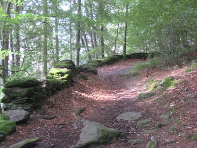
From Sargans train station, head to the west to the Zum Ritterhof hotel and continue alongside the railway line as far as the rail and motorway underpass. Then turn left into the village of Mels. The trail leads over the Seez bridge up to the hamlet of St. Martin with the little Nidberg castle. Follow the road for a short while and turn left at the large curve immediately at the start of the forest onto the old Vermolerweg trail. This continues mainly at a certain distance from the road up to Hintervermol. An occasional glance back into the Sarganserland area and into the Principality of Liechtenstein is always worthwhile. Continue at the same altitude over alpine pastureland, through woods and past several barns to reach Mülli, where the trail again meets the road into the Weisstannental valley. After around 200m, leave the road behind and climb uphill to the right. Then follow the high-alpine trail across varied terrain to Weisstannen. (Glarner Wanderwege)
Natural and cultural heritage
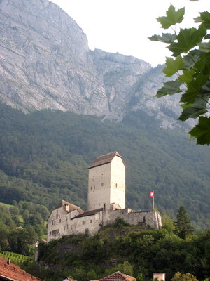
Mels With its surface area of 140km2, the community of Mels is the biggest community in the canton of St. Gallen. Iron ore was mined on the Gonzen at various periods in time between the 14th century and 1966. The extracted ore used to be stored in Mels, and an iron forge existed here as early as 1412. The large village square framed by interesting buildings also served between 1831 and 1861 as a “Landsgemeindeplatz” (a square where the cantonal legislation votes took place). Parish church of St. Peter and Paul, built between 1727 and 1732, late baroque renovation in 1922/23. Parish house, three-storey gabled building dating back to 1748. Capucine monastery, built between 1651 and 1654. Community administration centre, previously Haus Good, built in classical style in 1842. Group of houses from Haus Lendi to David-Nagler-Haus, typical 17th-century wooden constructions. Weisstannen The pretty little mountain village of Weisstannen is situated at the very back of the valley named after it. According to legend, the little village in turn got its name from a mighty silver fir, which once stood in the square that today accommodates the small parish church of John the Baptist built in 1665. Documentation on the village dating back to 1398 exists. The former administrative building built in 1772 for the alpine district of the Schanis monastery is the only old stone house that still remains in the valley. The first road through the wildly romantic valley was built in 1874. A magnificent linden tree several hundred years of age stands in the village square. (Schweizer Wanderwege)
Useful topographic maps
237 T Walenstadt ~ Swisstopo (1: 50'000)
247 T Sardona ~ Swisstopo (1: 50'000)
Glarnerland-Walensee ~ Hallwag Kümmerly und Frey AG / ISBN 3-259-00865-9 (1: 60'000)
Favourites, criticisms ? Make your personal comments on this stage. For more general notes please use the comments section of the page Over to the Via Alpinists.
Peter Starling - 2017-12-20
In sargans, we pitched on the remains of a parking lot near a small wildlife reserve around 47.035092 North, 9.423803 East.
...Probably not legal, but we figured it wouldn't hurt anyone if we stayed on the parking lot remains. No regrets.
The hike to Weisstannen is not strenuous and has plenty of water. Cheese can be aquired along the trail. There's also a small grocery store in Weisstannen, altho it wasn't open when we came by.
Tof - 2015-01-07
Trieste-Monaco le 20/8/14
Bivouac à Untersasse avant la montée pour le Foopass. Au-dessus d'un centre de vacances.
Ravitaillement possible en fromage à Vorsiez, un peu cher mais bon. Accueil juste commercial.
Automatic translation
[Google]
Trieste-Monaco on 20/8/14 Bivouac Untersasse before the rise for foopass. Over a resort. Can Vorsiez refueling cheese, a little expensive but good. Trade fair reception.
Der offiziell ausgeschilderte Weg führt ab Steinegg neu dem Bach entlang nach Weisstannen und folgt nicht mehr dem Höhenweg über Windegg.
Automatic translation
[Google]
The officially-marked path leads from Steinegg new along the river to white fir and no longer follows the trail via Windegg.
joan - 2011-09-22
Dortoir at Vorsiez, yes, but a little bit on the expensive side, plus they receive a lot of tourists groups. One of these big groups was using the dortoir first floor as a disco until midnight on the Saturday the 27th of August 2011 I slept there. Add to that that they want you to PAY for drinking water!.
Lou Papé - 2010-07-27
Pris sous une violente averse, nous avons trouvé un bon réconfort (café ét Schnaps) dans une cabane de chasseurs à Raminer Matt. Un grand merci à eux!
Automatic translation
[Google]
Caught in a heavy downpour, we found a good comfort (fl Schnaps coffee) in a hut hunters Raminer Matt. A big thank you to them!
Lou Papé - 2010-07-27
Possibilité d'hébergement bien agréable à Vorsiez pour ceux pour qui l'étape serait trop longue
Automatic translation
[Google]
Possibility of accommodation in Vorsiez nice for those who step would be too long

 |
4h30 |
12.4 km
|
727 m
|
230 m
|
4h30 |
12.4 km
|
727 m
|
230 m


Favourites, criticisms ? Make your personal comments on this stage. For more general notes please use the comments section of the page Over to the Via Alpinists.