Hiking (mountain trail, in places narrow and exposed)
Alpine route (equipped or very exposed section, snow field, blocks)
B37
Zams am Inn » Memminger Hütte
|
7h10 |
17.1 km
|
1832 m
|
361 m
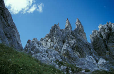
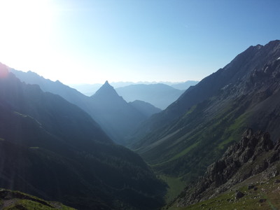
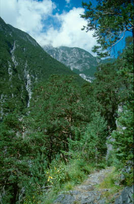
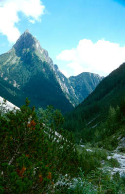
This part of Via Alpina is simply wonderful. Right in the heart of the Lechtal Alps, with no forest road, no cars and no buses. Only a narrow path through the impressive Lochbach ravine, then over the alpine pastureland and finally the sharp Seescharte ridge between the mighty Seescharte and Parseier peaks.
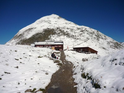
In Zams, follow the main road northwards. Immediately after the bridge over the River Inn, keep to the left and follow the little road to the left and then right in the direction of the Burschelkapelle chapel. This little chapel was erected by the women farmers of Zams. The well is there to provide refreshment for hikers who arrive on foot in Zams on the E5 or on Via Alpina from the Lechtal valley. In the opposite direction it is likewise advisable to gather one’s energy once again and fill all water bottles before entering the area of the Burschelwand peaks across the motorway, which disappears into a tunnel in this area. The steep path winds narrowly upwards through a lot of loose rocks. But once even the first climb is behind you, you are rewarded with a wonderful view over Zams, before Via Alpina disappears in the Zamser Loch. With the Lochbach river thundering far below, take just a lightly uphill route further into the beautiful ravine with its spruces, pines and larches. Several meters of altitude have yet to be climbed before a leisurely walk below the Silberspitze peak to the Schmiedlerskreuz and the Unterlochalm meadow (approx. 2h 30min from Zams). The track splits into two at the hunting lodge. While the right-hand path leads to the Württemberger Haus refuge, Via Alpina follows the left-hand path to the Oberlochalm meadow, which is cultivated simply in the summer months. A little bridge makes it easier to cross the Lochbach and on the left-hand bank the route continues through a copse. The stream must then be crossed once more before continuing across the gravel on a slightly uphill course. Later, the track gets better again and continues, alternating between light woodland and mountain pines, to the Oberlochalm meadow (approx. 1h from Unterlochalm). It only really becomes steep now, for here you must climb the so-called "Schweinrücken" (pig’s back). The path winds its way narrowly upward through the mountain pines. The view over the ever diminishing Oberlochalm meadow, the meandering stream and the Silberspitze peak is magnificent. The last stretch is so steep that you will need to use your hands in parts. But then, after approx. 2h 30min from the Oberlochalm meadow, you will reach the top and cross the sharp ridge on the Seescharte mountain at an altitude of 2,599m. The downward route on the other side is almost as steep and the Memminger Hut beside the three Semisee lakes can already be distinguished. After the descent, there is a leisurely walk through the barren basin-shaped valley along the Lower Semisee lake to the Memminger Hut of the German Alpine Club. After a strenuous climb to the Seescharte, you are advised to take care on the other side when walking down over the initially boulder-strewn terrain. (Christina Schwann, OeAV)
Natural and cultural heritage
The Lechtal Alps are a mountain range in the Northern Limestone Alps roughly 60km long and approx. 20km wide. The name originates from the Lech River flowing through the Lechtal valley and representing the last torrential river in Austria. The Parseierspitze peak standing at 3,036m represents the only mountain over 3,000m in the Northern Limestone Alps. The three highest pass roads in the entire Northern Limestone Alps cross the Lechtal Alps. These are the Hahntennjoch pass at an altitude of 1,894m, the Arlbergpass at an altitude of 1,793m and finally the Flexenpass at an altitude of 1,773m. From a geological point of view, the composition of the Lechtal Alps is extremely varied. This is due to the different stone nappes that have moved over each other during their development. In concrete terms, there are the Allgäu, Lechtal and Inntal nappes and also the Krabachjoch nappe as the uppermost tectonic component, now only existent in the massifs. But even these nappes are still interlapping and younger stone series are superimposed on older ones at the nappe borders. Wide stretches of the mountains and valleys are covered by unconsolidated material. Parts of this ground has settled and is already covered in tentative vegetation, while other parts are still evolving, which is particularly evident at the Lech itself, whose gravel patches shift after every flood. The main ridge of the Lechtal Alps consists in the so-called "Wettersteinkalk" limestone, a very hard stone that owes its firmness to the high proportion of limestone. It was formed by seaweed building up hundred-metre high reefs in shallow, well ventilated water above the receding sea bed. Green slopes with little detritus are characteristic of the Wettersteinkalk limestone. The Raibler nappes, on the other hand, behave in a very different manner. They are much softer and are therefore eroded at a faster pace. The Lechtal Alps have them to thank for the fact there is only crossing of the Hahntennjoch pass below 2,000m in altitude. The "dolomite" is, however, the most important component of the Lechtal Alps and occurs in all four nappe systems. Dolomite is a mixture of limestone and magnesite. The characteristic feature of dolomite is conspicuous areas of debris at the foot of the rock and furrowed, ruin-like shapes. Literature: Lexikon Österreich: Lechtaler Alpen Lechtal, eine Landschaft erzählt ihre Geschichte, Werner Gamerith, Tyrolia Verlag (Christina Schwann, OeAV)
Other long-distance trails and alternative routes
Ascent of the Paseierspitze peak (3,034m) via the Spielerweg trail (partly similar to a via ferrata), overnight stop at the Augsburger Hut. E5
Useful topographic maps
Nr. 3/3 Lechtaler Alpen, Parseierspitze ~ Oesterreichischer Alpenverein (1:25.000)
Favourites, criticisms ? Make your personal comments on this stage. For more general notes please use the comments section of the page Over to the Via Alpinists.
Jean-Louis Giraud - 2014-03-24
Petite erreur dans le texte précédent... lire verrou glaciaire :-)
Automatic translation
[Google]
Small mistake in the text above ... read ice bolt:-)
Jean-Louis Giraud - 2014-03-24
Longue et belle étape avec un dénivelé conséquent. Beaucoup de randonneurs croisés dans la raide montée du « schweinrucken », en fait un verrou glacière raide et bombé avec des pins de montagne pour seule végétation...et pour s’accrocher !
L’arrivée au Seescharte est spectaculaire ainsi que la traversée de la brèche ( cheminement sécurisé) avec la découverte des lacs et du vaste cirque ou est posé Memminger Hutte. Refuge complet avec beaucoup de randonneurs parcourant l’E5 en direction de Merano ou Bolzano.
Automatic translation
[Google]
Long and beautiful stage with uneven result. Many crossed the steep rise of "schweinrucken" hikers, makes it a steep and curved lock cooler with mountain pines for only vegetation ... and hang! The arrival Seescharte is spectacular and the crossing of the gap (trusted path) with the discovery of lakes and vast circus landed Memminger Hut. Full retreat with many hikers on the E5 in Merano and Bolzano.
Monaco - Trieste
Great location at Memminger Hutte, 10euros for a bed + cold shower and electricity
First sip of lovely Franziskaner Weiss bier :-)
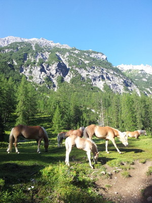
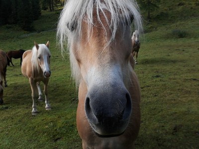
Zams is reachable in less than 4h from Memmingerhutte. water stream and restaurant at Unterlochalpe, Haflinger horses.
philippe - 2010-08-05
casse croute buvette a Unterlochalpe.et le schnaps offert pour les campeurs!
Automatic translation
[Google]
casse croute Unterlochalpe.et a refreshment schnapps offered for campers!

 |
7h10 |
17.1 km
|
1832 m
|
361 m
|
7h10 |
17.1 km
|
1832 m
|
361 m


Favourites, criticisms ? Make your personal comments on this stage. For more general notes please use the comments section of the page Over to the Via Alpinists.