Hiking (mountain trail, in places narrow and exposed)
Alpine route (equipped or very exposed section, snow field, blocks)
B35
Braunschweiger Hütte » Wenns
|
9h05 |
37 km
|
352 m
|
2098 m
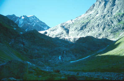
You leave the world of glaciers behind on an impressive descent alongside the glacier tongue of the Mittelbergferner glacier and the rollicking Pitze brook, arriving back in civilisation along the Pitz valley in a leisurely fashion with the mail bus.
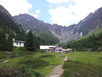
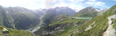
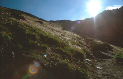
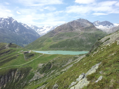
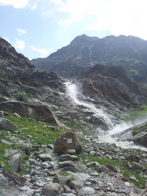
From the Braunschweiger Hut, the trail now goes down in a western and north-western direction on the E5. The track is initially very pleasant to walk along, as there are still relatively few steep parts. It is only after the bench on the right-hand side, which invites you to take a rest – something that you should by all means do, given the wonderful view over the Mittelbergferner glacier – that it becomes steeper and narrower. Part of the trail passes very close to the Pitze, a glacier stream fed by the Mittelbergferner. The grey colour of the water is, incidentally, due to the high silt content caused by the glacier erosion and not to pollution caused by man. The loudly roaring water tumbles into the depths. Impressive waterfalls bear witness to the power of water. After the steep descent, things start to get easier. Follow the widening path only slightly downwards along the Pitze, which has by now regained its composure and babbles along at a comfortable pace. The Gletscherstüberl is an inviting inn where you can take a rest. The decline of the Mittelbergferner is well documented. In around 1859, the glacier tongue came down to 1,809m above sea level, and by 1922 still reached as low as 2,020m. In the mid-1930s, the glacier mouth was even used by the inhabitants to refrigerate meat and the Gletscherstüberl inn invited guests to observe the glacier tongue in a cosy atmosphere. Now, there is hardly any “eternal” ice left to see from the little inn, as the glacier tongue has shrunk to approx. 2,400m above sea level. From the Gletscherstüberl inn, a gravel roadway leads to Mittelberg (approx. 2h). There is a regular mail bus service that can be used to travel comfortably out of the entire Pitztal valley as far as Wenns (approx. 1h). You can marvel along the way at the steep slopes on which the damage caused by avalanches can be seen everywhere. It is of course possible to walk through the Pitztal valley on foot as far as Wenns. A newly structured path along the Pitze stream for hikers and mountain bikers makes for a comfortable route. A stop-off in one of the lovely villages of the Pitztal valley is, however, highly recommended. (Christina Schwann, OeAV)
Natural and cultural heritage
A so-called “emergency road” has been marking the end of the Pitzal valley since Autumn 2006. There, where Via Alpina and the E5 path lead from Braunschweiger Hütte mountain refuge to the lower Mittelberg, a way up to 12 metres wide has been dug into the rocks, and should enable evacuation of the nearby skiing resort in case of danger. Previously, one could only leave the Pitzal skiing area, which is North-West of the Braunschweiger Hütte, from a gallery in the rocks, but after the tragic accident occurred in 2000 at Kaprun, when 155 people died because of a fire that broke out in the gallery, the opinion of building a downhill track for security reasons strenghtened out. After a long debate and an annulment due to negative results of the environment impact inspection (UVP), the project has been changed according to the environmental impact plan and the downhill track has officially become the emergency way out usable just in case of impracticability of the gallery. Nevertheless, its intrusion into the natural environment is huge, and it enormously damages the landscape. Moreover, it must still be verified how such a way out will be used in Summer according to the building plans. Glaciers worldwide are receding, and this includes all of the glaciers in the Pitztal and Kaunertal valleys, which have shrunk back by between 15 and 23m. This development is of significance, given that the glaciers represent a large proportion of the freshwater reserves and the ongoing pollution caused by skiing accelerates the melting. That is why the glaciers are subject to very special protection, anchored in the nature protection legislation of Tyrol. The Pitztal basically runs from the North to the South and is a side valley of the Inntal. The four communities of Arzl, Wenns, Jerzens and St. Leonhard stretch out over a distance of approx. 40km. St. Leonhard, with an area of 223km², is the third biggest community in North Tyrol. The community was first mentioned in documents in the year 1265 for the purpose of a farm exchange. The village locations of the 49 settlements were deliberately chosen for the protection provided by the woods above from the great danger posed by debris flows, avalanches and rock falls. The first settlements were formed by the so-called "Schweighöfe" farmsteads. These are cattle farms on which it was not possible to cultivate cereals due to their high-altitude location. The owners, Starkenberger, Hirschberger and also the Stams monastery, enfeoffed the farmers, i.e. they had to give a share of their yield in return for cereals and bread. Today, the most important economic sector in the Pitztal valley is tourism. World-famous skiers like Benni Raich feel at home in the Pitztal and skiing tourism is of course of the utmost importance, although the Pitztal also has a lot to offer in the summer: horse riding, cycling, swimming, tennis, tranquillity and relaxation. Literature: St. Leonhard im Pitztal, Kerstin Blassnig/Renate Schnegg, Loewenzahn (Christina Schwann, OeAV with the kind support of Dr. Hans Haid)
Other long-distance trails and alternative routes
1. It is possible to walk through the Piztal valley on foot. However, this requires an extra day and an overnight stay in St. Leonahrd. (signposted mountain bike trail). 2. alternative route via the Riffelsee lake, Kaunergrat Hut, Verpeil Hut, Kauns and Piller (trail via Kaunergrat ridge difficult and only advisable for experienced mountaineers). E5
Favourites, criticisms ? Make your personal comments on this stage. For more general notes please use the comments section of the page Over to the Via Alpinists.
Monaco - Trieste
Wenns can be avoided and also the bus ride to Mittelberg.
From Galflun hutte it can follow E5 variante by Verpeil Hutte following Dr. Angerer Hohenweg.
Local map of this aera can be found at Zams tourist office.
From Verpeil hutte to Braunschweiger hutte, there is a high point over 3000m that is very steep and also includes ladders and vertical way that can be dangerous if wet or in case of bad weather. this variante is really worth it.
Kaunergrat hutte near Watzespitze have a great location and offers accomodation also
in between Galflun hutte and Verpeil hutte there are 3 places to get food. in between Verpeil hutte and Braunschweiger hutte there are at list 3 places to get food also. Passing by Rifflesee
it takes 2 days from Galflun to Braunschweiger, but really worth going radther than riding a bus in between Wenns and Mittelberg
jeroen wiemer - 2012-02-28
does anyone: 1) knows if the other way (mittelberg - bh - zwieselstein is OK and 2) if i can do this with a child of 8 years old?

 |
9h05 |
37 km
|
352 m
|
2098 m
|
9h05 |
37 km
|
352 m
|
2098 m


Favourites, criticisms ? Make your personal comments on this stage. For more general notes please use the comments section of the page Over to the Via Alpinists.