Randonnée (sentier de montagne, parfois étroit et exposé)
Randonnée alpine (passage équipé ou très exposé, névé, blocs)
R36
Pfitscherjoch / Passo Vizze » Ginzling
|
5h40 |
24.6 km
|
86 m
|
1358 m
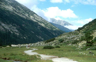
Au départ du col Pfitscher Joch, le tracé suit la pittoresque vallée Zamser Grund jusqu’au lac de barrage Schlegeisstausee. Cette destination populaire d’excursion est en général très fréquentée, mais après le mur de soutènement on retrouve le calme. Après Breitlahner, la Via Alpina suit le sentier découverte « Lass dir erzählen » (« Laisse-nous te raconter »), qui met à la lumière de nombreuses spécificités oubliées de la vallée Zillertal.
Au col de Pfitscherjoch, traverser la frontière italo-autrichienne à 2 246m. Le sentier de randonnée descend sur la vallée de Zamser Grund. Sauter par-dessus le cours d’eau Zamserbach et les nombreux ruisseaux qui tracent leur lit par ce fond de vallée. Une petite chapelle est située à côté de l’auberge Zamsgatterl. À gauche, se trouve un parking pour des voitures ayant pris la route à péage du lac artificiel Schlegeisstausee, qui est une attraction touristique pendant les mois d’été. Par cette route, on peut rapidement voir le refuge Dominikushütte, qui se trouve un peu plus haut sur la gauche. Au niveau du dernier parking avant le tunnel, le sentier descend sur la droite en direction de Breitlahner, juste derrière le barrage. Le sentier descend par des virages serrés. L’impressionnant barrage plonge peu à peu le randonneur dans son ombre. Un sentier de randonnée descend tranquillement pour sortir de la vallée. Là où le sentier rencontre la route, traverser-la et continuer de l’autre côté, sur la droite du sentier, qui part vers les refuges Friesenberghaus et Olperer Hütte. Continuer sur le sentier d’alpage jusqu’à arriver au-dessus du poste de péage. Quelques virages serrés sont encore à prendre à travers bois avant d’arriver à la route et, immédiatement après, il est possible de voir la pension alpine Alpengasthof Breitlahner sur la droite (3h40 depuis le refuge Pfitscherjoch-Haus). Prendre la route entre la pension Gasthof Breitlahner et l’alpage Kaserleralm, car aucun sentier n’existe officiellement sur le côté est du cours d’eau. Après une trentaine de minutes, une petite route bifurque sur la gauche juste après l’alpage Kaserleralm. La suivre (il ne s’agit pas du chemin qui monte sur la gauche de l’alpage Birgelbergalm) sur un relief légèrement ondulé. La pension Gasthof Roßhag invite au repos avant de prendre la route, plus large, en direction de la centrale électrique de Roßhag. Continuer vers la gauche (pas à droite par le pont), avant de continuer sur Ginzling. À Ginzling, rester sur le côté ouest du Zemmbach (ne pas traverser le pont), passer l’église et le petit pavillon de chasse. À l’alpage Kaserleralm, rester sur la route jusqu’à Breitlahner. Le sentier monte à travers bois juste après le poste de péage. Rester sur ce sentier jusqu’au refuge Friesenberghaus, traverser la route et continuer la marche de l’autre côté. (Gudrun Wallentin, Christina Schwann, Parc naturel alpin Zillertal, OeAV)
Patrimoine naturel et culturel
Le Parc naturel de haute montagne des Alpes du Zillertal s’étend sur une superficie de 372 km². Avec le Parc national Hohe Tauern et le Parc naturel Rieserferner-Ahrn du Haut-Adige, ces trois espaces protégés forment la plus grande association d’espaces protégés contigus des Alpes. Ils ont tous trois les mêmes objectifs : 1. protection et exploration du paysage naturel ; 2. information et pédagogie environnementale ; 3. découverte de la nature et du paysage ; 4. développement régional durable et préservation du paysage culturel. Le Parc naturel des Alpes du Zillertal, qui a reçu le statut d’espace protégé en 1991 (« Ruhegebiet » ou zone de repos), est situé sur les communes de Mayrhofen, Finkenberg et Brandberg et sur le hameau de Ginzling du district de Schwaz. Le sentier allant du col de Pfitscherjoch au lac artificiel Schlegeisstausee passe directement par cet espace protégé de haute montagne. La Via Alpina longe ensuite à sa bordure en direction de Ginzling. Les possibilités de génération d’électricité ont été découvertes très tôt dans les Alpes de Zillertal : la centrale électrique de Gerloskraftwerk a été construite en 1939, le lac artificiel de Durlaßboden en 1963 et celui de Nevesspeicher en 1964. Le barrage du lac de Schlegeisspeicher a été terminé en 1972, après presque 5 ans de construction. Quand le lac est plein, le mur de 131 mètres de hauteur et 725 de longueur peut retenir 126,5 km³ d’eau. Le refuge Dominikushütte qui existait à l’époque a été inondé et a dû être reconstruit un peu plus haut. Aujourd’hui, le parc naturel empêche toute nouvelle exploitation technique de grande ampleur, comme l’autoroute « Alemagna » : dans les années 70, des plans ont surgi pour le tracé de l’axe entre l’Italie et l’Allemagne passant par les vallées de Zillertal et d’Ahrntal. Maintenant, la construction d’une telle route est légalement interdite sur le territoire autrichien grâce à la Convention alpine. Malgré cela, l’Alemagna n’a pas été totalement stoppée : elle est déjà ouverte de Mestre à Trévise et de Vittorio Veneto à Belluno et Pieve di Cadore. Le parc naturel non seulement joue un rôle politique important mais représente également une vaste zone écologique pour équilibrer les sites touristiques surexploités de la vallée de Zillertal. Des falaises abruptes, de vastes étendues de pins Cembro, une grande population de rhododendrons et de nombreux alpages fleuris : ce paysage naturel de haute montagne encore préservé offre un habitat à une multitude d’animaux et de plantes. On peut y voir des aigles, des marmottes et des chamois. Avec un peu de chance, il est même possible de voir un hôte encore rare mais régulier : le gypaète barbu, un charognard avec une envergure de plus de 2,5 m. (Christina Schwann, OeAV, Gudrun Wallentin, Parc naturel Zillertal)
Autres grands itinéraires et variantes
Depuis le refuge Dominikus, prendre le tournant en direction du gîte Friesenberghaus, où se trouvent un mémorial juif et un panorama magnifique. Retour sur la Via Alpina au niveau de Breitlahner.
Cartes topographiques utiles
35/2, Zillertaler Alpen, Mitte und 35/1, Zillertaler Apen, West ~ Oesterreichischer Alpenverein (1:25.000)
Coup de cœur, critique ? Entrez votre propre commentaire sur cette étape. Pour des remarques plus générales, merci d’utiliser la fonction commentaire de la page La parole aux Via Alpinistes.
Raphael - 26/09/2023
After reading the previous comments on R36 and R37, I decided to replace them by two legs of the „Berliner Höhenweg“ (check: https://www.tirol.at/reisefuehrer/sport/wandern/wandertouren/a-wanderung-berliner-hoehenweg). I replaced R36 with hiking to the Friesenberghaus and R37 by going from the Friesenberghaus to the Gamshütte. Both were very nice trips, which were not too demanding at most parts but included large boulders again, which were difficult in the rain. Still, the tours had very scenic views on the Zillertal and the Schlegeisspeicher and the huts were nice and with friendly service. From the Gamshütte I descended to Mayrhofen, which takes around 3h. If you want to avoid walking roads down in the valley I strongly suggest taking this option!
Carsten - 10/01/2022
(2) Half a dozen buses a day run from the dam of the Schlegeis reservoir (about 5km into this stage) to Ginzling and on to Mayrhofen (resupply). I did not see a shop in Ginzling (or anything else of interest). Restaurants were closed, and I didn't look for and didn't see accommodation.
In good weather, from near the dam of the Schlegeis Reservoir (or perhaps where one first reaches the reservoir) it’s possible to follow signposts for sections of the Berliner Hoehenweg via the Olperer Huette and the Gams Huette to Finkenberg (a worthy highline trail). Google Berliner Hoehenweg for more information. Probably really nice.
Carsten - 10/01/2022
(1) WARNING R36 starting from the Schlegeis Reservoir through halfway of R38 is a Via Horribile Anti-Alpina (low-level valley walk, on or near asphalt roads (with cars), nothing to see...)
Default: Take the bus from the Schlegeis Reservoir to Mayrhofen (full resupply, affordable hotels), and then a bus from Mayrhofen to Moesl (the Finkenberg-Moesl leg is a pointless up and down in a non-satisfying environment). From Moesl, it’s possible to walk to Schwaz (end of R40) in one day (R39 and R40 double-count the ascent to Kellerjochhuette, and one may well bypass the final climb to that hut). Schwaz (also) has excellent resupply. -- I am not in favor of taking buses to shorten the distance walked, but the situation here is different from Pragser Wildsee to St Martin, which gave me a nice impression of the changing landscape. Here, in R36-R38, there is nothing worth to be experienced; the routing is plain offensive.
Lolo - 29/07/2019
Passage en Autriche. Descente le long du mur du barrage. Descente le long de la rivière. Suivre le chemin balisé car il y a des tunnels à passer par la route. A Ginzling je décidé de continuer jusqu'à Finkenberg 10 km de plus. Balisage moyen...
POPEYE GG - 13/06/2018
11 juillet 2017
Aucune difficulté pour cette étape malgré la grande dénivelée en descente (1400m).
Toujours de beaux panoramas avec ici une multitude de cascades.
Le chemin passe au pied d'un barrage, équipé d'une impressionnante via ferrata.
A Ginzling, pour l'hébergement, le plus simple est d'aller voir l'office du tourisme: je recommande l'hôtel Schwarzenstein: pour plus de détails, voir aussi mon blog "vivelaretraitesurlaviaalpina.blogspot.com".
Between Ginzling and Breitlahner is an official Bivouac field. It's next to the road and full of rockclimbers :-) People might call it a campsite (and they might say it's in Ginzling), but in both cases you'll be disappointed.
Domenikus Hütte is a very nice place indeed. They have no problem with camping for 1 night as long as you ask. Super friendly staff who love to "help" hikers. Warmly recommended!
Traduction automatique
[Google]
Entre Ginzling et Breitlahner se trouve un terrain de bivouac officiel. C'est à côté de la route et plein de rochers :-) On pourrait appeler ça un camping (et on pourrait dire que c'est à Ginzling), mais dans les deux cas, vous serez déçu. Domenikus Hütte est un très bel endroit. Ils n'ont aucun problème à camper pendant une nuit, aussi longtemps que vous le leur demandez. Personnel super sympa qui aime "aider" les randonneurs. Chaudement recommandé!
gianadda marie-jo - 17/08/2015
Sommes descendues jusqu'à Hôtel Breitlahner. Itinéraire de fond de vallée encore assez sympa.
When you arrive at the newly rebuilt Pfitscherjoch Hut, you instantly feel the urge to move on!
The privately owned Dominikushutte is great. Owners are very friendly, and they have a free laundry service!
Traduction automatique
[Google]
Lorsque vous arrivez à la cabane Pfitscherjoch nouvellement reconstruit, vous sentirez immédiatement à l'envie de passer à autre chose! Le Dominikushutte privée est grande. Les propriétaires sont très sympathiques, et ils ont un service de blanchisserie gratuit
Elisabeth - 24/12/2012
Prix prohibitif à Pfitscherjochhaus (6 € l'apfelstrudel !)
Traduction automatique
[Google]
Prix à prohibitif Pfitscherjochhaus (6 € l'strudel aux pommes!)
Alpinisten - 24/09/2012
Wir können die Dominikushütte wärmstens empfehlen! Kamen vonr der Hochfeilerhütte und hatten keine Lust auf den Baulärm am Pfitscher Joch (Umbau)...Sehr gut essen kann man im Gasthof "Alt-Ginzling" (Familie Kröll), die aber keine Übernachtung anbieten.
Traduction automatique
[Google]
Nous vous recommandons fortement l'Dominikushütte! Entré au refuge ofr Hochfeiler et n'avait pas de temps pour le bruit des travaux sur Pfitscherjoch (reconstruction) ... Très bon, vous pouvez manger à la "Ginzling Alt" auberge (famille Kroell), l'offre, mais pas de nuitées.
Mountain Girl - 21/12/2011
As you come into the village of Ginzling (from Passo Vizze), the first house with a sign for "Zimmer" (rooms) is comfortable. Food options in Ginzling are limited to a bakery with sporadic hours, and a Gasthof, that also offers rooms.
Traduction automatique
[Google]
En entrant dans le village de Ginzling (à partir de Passo Vizze), la première maison avec un panneau "Zimmer" (chambres) est à l'aise. Choix d'aliments à Ginzling sont limités à une boulangerie avec des heures sporadiques, et une Gasthof, qui propose également des chambres.
Mountain Girl - 27/10/2011
Dominikushuette is the first hut coming off the Passo Vizze -- 8km down--and a welcome choice. Hosts love hearing hiker stories, offer great food and comfortable lodging. Plus, there's a superb view of the glacier outside the dining room window. Highly recommended!
Traduction automatique
[Google]
Dominikushuette est la première cabane à venir au large de la Vizze Passo - 8km vers le bas - et un choix de bienvenue. Les hôtes aiment entendre des histoires de randonneurs, propose une excellente cuisine et un hébergement confortable. De plus, il ya une superbe vue sur le glacier en dehors de la fenêtre de la salle à manger. Hautement recommandé!

 |
5h40 |
24.6 km
|
86 m
|
1358 m
|
5h40 |
24.6 km
|
86 m
|
1358 m


Coup de cœur, critique ? Entrez votre propre commentaire sur cette étape. Pour des remarques plus générales, merci d’utiliser la fonction commentaire de la page La parole aux Via Alpinistes.