Randonnée (sentier de montagne, parfois étroit et exposé)
Randonnée alpine (passage équipé ou très exposé, névé, blocs)
R8
Planinska koča na Ermanovcu » Porezen
|
5h30 |
16.9 km
|
1196 m
|
574 m
L’itinéraire parcourt le massif vallonné de Cerklje. Suivre la route qui s’enroule autour des versants couverts de forêts et de prairies. Cette route remonte à la 1ère guerre mondiale lorsque la région appartenait à l’Italie. Visiter ensuite l’hôpital des Partisans de Franja qui a joué un grand rôle pendant la 2ème guerre mondiale. Monter un sentier à travers prés et forêts conduisant à Porezen.
Du refuge descendre la route vers le col de Kladje jusqu’à la ferme Vrhovec, où l’itinéraire tourne à droite et commence à monter légèrement. Contourner le sommet du Šanc (1048 m) puis atteindre une ancienne caserne militaire italienne abandonnée. Pénétrer dans la forêt et descendre jusqu’à une route sur laquelle on tourne à droite. Suivre cette route sur 100 m jusqu’à un croisement. Tourner à droite sur un chemin carrossable, abandonné par endroits, qui descend doucement et passe près de la ferme Jeram. On arrive à un croisement situé sur le col, dénommé Vrh Ulce (814 m), au sommet duquel se trouve un objet en bois. On se trouve à la limite de partage des eaux entre la mer Noire et la mer Adriatique. 50 minutes. Tourner à droite sur la route Kladje – Hotavlje que l’on quitte bientôt pour avancer dans la forêt sur une ancienne route italienne bien conservée qui reliait autrefois Novaki et Kladje. Lorsqu’on arrive sur une prairie, on peut profiter de la belle vue sur le Porezen (1630 m). On continue sur la route qui vire bientôt brusquement à droite et on se retrouve sur le versant sud du Škofelj que l’on commence à monter doucement. Continuer sur la même route qui conduit au-dessus du village de Dolenji Novaki. Tourner à droite au croisement, continuer tout droit en descente puis passer un nouveau croisement et suivre la glissoire à bois dans la même direction. Un chemin agréable conduit jusqu’au bord d’une clairière que l’on traverse le long d’un chemin difficile à repérer et que l’on suit jusqu’à une étable. Après avoir passé l’étable, on traverse le ruisseau Cernica et on rejoint la route régionale Cerkno – Črni vrh à hauteur du village Dolenji Novaki (450 m). 50 minutes. On suit la route en direction de Cerkno, qui tourne à gauche et on arrive en cinq minutes à un croisement. On tourne sur une route latérale goudronnée qui monte vers une auberge située à l’entrée des gorges de Pasice où se trouve l’hôpital de l’armée partisane slovène Franja. Du pont il faut compter 20 minutes. Pour atteindre l’hôpital, il faut marcher encore 10 minutes sur un sentier touristique aménagé dans les gorges. Via Alpina franchit le ruisseau Pasica qui coule le long des gorges et suit une route en direction de l’ouest pour arriver au pied de la montagne de Drnova (1004 m). Traverser le hameau de Podnjivč et parvenir au village de Poljane (510 m) en environ 40 minutes. Traverser le village, continuer jusqu’aux prés et champs qui le surplombent. De là, un sentier monte une pente boisée très escarpée, en suivant tout d’abord le ruisseau Trševka qui, par endroits, tombe presque à la perpendiculaire. Ensuite, on rejoint un sentier forestier que l’on traverse seulement avant de continuer à grimper jusqu’à un croisement situé à proximité des prés de Labinjska leha où arrive sur la gauche le sentier qui vient du village de Cerkno. Continuer à travers prés vers le versant escarpé de Cimprovka (Koap, 1360 m), que l’on évite par la gauche. Ensuite, on grimpe en traversant des prés d’alpage et on arrive à une forêt. Le sentier se rétrécit et conduit au col de Velbnik (1331 m). Sur la gauche, on aperçoit une cabane de chasse. De Poljane il faut compter 2h 10 minutes. La route conduit à Porezen tandis que l’itinéraire franchit le Jalovec (1410 m) à l’entremontagne de Medrce où se croisent de nombreux sentiers de randonnée de montagne ainsi qu’une route forestière. On continue sur cette route et on arrive au refuge Dom Andreja Žvana – Borisa na Poreznu (1590 m), qui est situé sur le versant nord du Porezen (1630 m), tout en dessous du sommet. Du col il faut compter 40 minutes. L’étape dure 5h 30 minutes.
Sources : Dobnik, Jože. (1998). Slovenska planinska pot. Planinski vodnik. Založba: PZS. Atlas Slovenije. (1996). 3. izpopolnjena in razširjena izdaja. Ljubljana: Mladinska knjiga in Geodetski zavod Slovenije (GZS). Škofjeloško in Cerkljansko hribovje. (1993). Izletniška karta. 1:50.000. Ljubljana: GZS. Julijske Alpe – vzhodni del. (2003). 1:50.000. Ljubljana: Planinska založba PZS in GZS. (Peter Šilak)
Patrimoine naturel et culturel
Ermanovec invite à un temps de réflexion sur les frontières puisque le refuge est situé à proximité de l’ancienne frontière séparant l’Italie de la Yougoslavie d’alors. Après la première guerre mondiale, la crête qui partage depuis des millions d’années les bassins hydrographiques de l’Adriatique et de la Mer noire a également séparé ces deux pays (traité de Rapallo). Les grandes puissances avaient décidé d’annexer une partie du territoire slovène à l’Italie et ce pour une période de vingt ans. L’Italie d’un côté et la Yougoslavie de l’autre ont commencé à renforcer leurs positions le long de la frontière et à construire des routes, des postes de gardes frontière, des fortifications imposantes et des bunkers sur les sommets. En Yougoslavie, ce système de défense a reçu le nom de Ligne de Rupnik (Rupnikova linija) et en Italie le nom de Mur alpin (Alpski zid). Le sommet de l’Ermanovec abrite des bunkers de la Ligne de Rupnik. A proximité, près de la ferme des Vrhovec, sur le chemin qui conduit à Kladje et Škofje, on peut voir les restes de casernes italiennes. Le chemin qui part d’Ermanovec en direction de Porezen passe sous la montagne de Škofja. Ce lieu de passage a toujours eu une certaine importance et a accueilli différents peuples. Le commerce a alors fleuri des deux côtés. Les Romains ont renforcé ce passage à l’aide d’un système de barrages comme on l’a déjà rencontré à Hrušica. La montagne est criblée de trous puisqu’elle renfermait une mine de cuivre, l’une des rares ayant existé en Slovénie. L’ancienne route militaire italienne, que suit notre chemin, évite le sommet car elle devait cacher aux yeux de l’ennemi le traffic qui l’empruntait. Le chemin descend en pente douce vers le village de Novaki, à l’étroit dans la vallée située sous le Porezen. Au fond de gorges sauvages est enfouit un souvenir de la dernière guerre mondiale alors que la nation slovène était dans une situation critique, attaquée par les fascistes et les nazis auxquels les combattants partisans ont opposé une farouche résistance. Le plus beau souvenir de cette résistance et de l’incroyable ingéniosité humaine est l’hôpital des partisans de Franja. Dans la gorge de Pasica, secrète et bien cachée, les partisans ont construit un véritable complexe hospitalier avec une salle d’opérations et un appareil à rayons X. L’ennemi n’a jamais pu la découvrir, ce grâce à la bravure des habitants de Novaki d’où part aujourd’hui le chemin qui conduit au musée de l’hôpital. Dans la région entourant Cerklje, on peut observer des maisons typiques de cet endroit dont un bel exemple se trouve à Novaki à proximité de l’hôpital des partisans. La demeure des Kamlonarše renferme un beau symbole de l’architecture slovène, le “kozolec”, une structure en bois servant à faire sécher et entreposer le foin. De nombreuses défenses militaires, souvenir de la guerre et de l’intolérance, longent notre chemin jusqu’au sommet du Porezen. Heureusement, les plaies guérissent, le béton et l’acier se recouvrent de végétation parsemée de fleurs multicolores à l’approche du printemps. Sources : http://www.ars-cartae.com/siteo/index.htm (Rupnikova linija in Alpski zid) http://oreh.pef.uni-lj.si/~markor/kaverne/ (Alpski zid) http://www.cerkno.si/turizem/ http://www.burger.si/MuzejiInGalerije/MestniMuzejIdrija/Franja/BolnicaFranja_Uvod.html http://www.muzej-idrija-cerkno.si/carmina/franjas.html Aleksander Jankovič - Potočnik. (2004). Rupnikova linija in Alpski zid. Vrhnika, Galerija 2. Tomaž Pavšič. (1999) Ob stari meji. Idrija, Založba Bogataj. (Igor Maher)
Cartes topographiques utiles
Škofjeloško in Cerkljansko hribovje ~ Geodetski zavod Slovenije (1 : 50 000)
Guides de randonnée utiles
Slovenska planinska pot ~ Planinska zveza Slovenije (ISBN 961-6156-11-x)
Vodnik po planinskih postojankah v Sloveniji ~ Planinska zveza Slovenije (ISBN 961-6156-10-1)
Galerie photos
Ajoutez vos propres images!
Commentaires
Coup de cœur, critique ? Entrez votre propre commentaire sur cette étape. Pour des remarques plus générales, merci d’utiliser la fonction commentaire de la page La parole aux Via Alpinistes.
Vegiwölfe - 03/09/2024
Diesmal hat es geklappt mit der Porezen-Hütte. Die Bewartung war sehr freundlich und Hilfsbereit. Die Hütte selbst ist ganz ok, die sanitären Anlagen könnten wieder einmal aufgefrischt werden.
Rembert Biemond - 31/03/2024
continued....
The hut was winterclosed.
We had considered the winterroom which is a 2m x 1,5 m part of the firewoodshed. with two "beds" and emergency water. But unheated. We had decided against it (we were 3) which was a wise decision and continued with the first part of the next stage. Note that this stage has > 1200 meters up and will be if you start from Triest a new altitude record. View from the top is superb.
Rembert Biemond - 31/03/2024
Please note that the end of the previous stage is identical with the first part of this stage for at least an hour In other words - if you are purist you do it (we did), or if you plan to overnight at the hut (which we couldnt , winterclosed. Then it is for quite some km an easy route, but as commented by others the steep part up from Poljane is rough to say the least. For a good part maybe because of recent forest works it was not really a path and it slowed us down. I think the 2 km or so took us two hours.
We started at 6:15 with the last part of started stage 7 at 7:30 stage then we needed 8 hours to complete stage 7.
Yes, some 45% more then indicated on this page.
Vegiwölfe - 16/09/2023
Die Porezenhütte ist ab 17. September geschlossen. End of season. Im Biwak könnte man noch übernachten.
Das Franja-Partisanenkrankenhaus ist leider wegen Sturmschäden vorübergehend geschlossen.
flautix - 20/08/2023
Wir kamen im Nebel auf der Hütte am Porezen an und waren mit zwei Sloweninnen zusammen die einzigen Gäste. Im beheizten Gastraum wurden wir bestens versorgt und sehr freundlich von den beiden Hüttenwirtinnen bedient.
Valentine - 27/06/2023
Highly recommanded to stay at Damian’s place. There are some beds or you can camp here. The family is so nice!
Ingo - 17/09/2022
There is no shop in Dolenji Novaki!!! And no shop later on. So, you should stock up with food before (on R7 or in Cerkno).
Bernd - 01/09/2022
Einen Abstecher zum Franja-Partisanen-Krankenhaus ist trotz Eintrittsgelds absolut empfehlenswert! Am Startpunkt-Haus kann man seinen Rucksack abstellen, bei den Toiletten gibt es kostenlos Frischwasser.
Bernd - 01/09/2022
Die Hütte ist nur von Mitte Juni bis Mitte September durchgehend bewirtschaft, ansonsten nur an den Wochenenden bei gutem Wetter (detaillierte Infos unter http://www.planinsko-drustvo-cerkno.si/eng.htm). Unsere beiden Gastgeberinnen waren überaus freundlich und sprachen ausreichendes Englisch.
Oliver - 07/07/2022
As it has rained hard the previous night I decided against the super steep ascend from Poljane. Instead I went from kladje to cerkno (trail, bus, autostop, whatever you prefer) and then ascended the clearly marked trail to Labinje/Bolnica Franja. In Labinje just follow the clearly marked trail to porezen all the way to the top. You'll meet the original route automatically. This second part of trail, even though it is in good condition and very clearly marked was not shown in my GPS App. Overall the ascend remains steep, but probably not as bad as from Poljane. It was easily doable even in wet conditions.
Carsten - 10/01/2022
Consider descending from Kladje (2.5km before the end of R7) to the larger village of Cerkno (and spend the night in a nice hotel), then walk a road (could be a dirt road) to meet the Via Alpina in R8 at c.1000m altitude. Cerkno is little below the lowest point of R8. On the Via Alpina, the first 300m altitude gain from Poljane are on a trail with a 45 degree incline, the next 200m (to reach 1000m) on a 30 degree incline, i.e. are brutally straight up. Alternative: go from Cerkno to Poce and take the trail from there directly to the peak, joining R9 c.200 altitude meters below the peak.
Water: 500m above lowest point, creek crossing; subsequently several creeks up to c.800m altitude; trough c.100 altitude meters below peak with clean trickle after rain; sound of running water from enclosed area 20m off trail c.50m altitude below peak. Faucet outside hut (end of R8) with sign that not potable.
pascal - 06/09/2019
Le 12/06/2019
Le refuge de Porezen étant fermé à notre arrivé, nous sommes descendu à Petrovo brdo où nous avons trouvé l'auberge PLANINSKI DOM tenue par Irena et Rudolf Zgaga. Emplacement pour la tente, douche, repas pour 24€. Très bon accueil.
kessel_kolumna - 03/07/2019
Wir können Barbara & Peter nur zustimmen. Bei Rudi ist es super. Er fuhr uns auch für 10€ nach Podbrdo zum Bahnhof. Über Jesenice kommt man von dort problemlos nach Österreich, z.B. Villach und von dort nach Hause. Ist ein guter Ausstieg für alle, die wie wir die ViaAlpina nicht in einem Jahr laufen können.
Traduction automatique
[Google]
Nous ne pouvons qu'être d'accord avec Barbara et Peter. C'est génial avec Rudi. Il nous a conduit pour 10 € à Podbrdo à la gare. À propos de Jesenice, vous pouvez facilement aller de là en Autriche, par ex. C’est un bon moyen pour ceux qui, comme nous, ne peuvent pas exécuter ViaAlpina en un an.
Barbara/Peter - 14/07/2018
Wir sind vom Porezen abgestiegen und haben in Petrovo brdo genächtigt. Hütte mit zwei netten Zimmern und überaus gastfreundlichem Wirt (Rudi). Sehr empfehlenswert.
Traduction automatique
[Google]
Nous sommes descendus de Porezen et avons passé la nuit à Petrovo Brdo. Cottage avec deux belles chambres et hôte extrêmement hospitalier (Rudi). Fortement recommandé.
POPEYE GG - 12/06/2018
14 juin 2017
J'avais prévu de m'arrêter au refuge de Porezen, mais il n'était pas ouvert (c'était un mercredi, ouvert seulement en week-end comme celui de R7?), et le temps semble se gâter. Je continue donc jusqu'à Petrovo Brdo (début de R9) et tombe sur le gîte du même nom. Le gardien est très sympa et m'a accueilli avec une goutte pouir me réchauffer (ça tombe bien, car je il s'est mis à pleuvoir juste en arrivant!).
Tine - 01/11/2017
Sleeping accommodation at Nadja`s Pro Milki in Doljeni Novaki is perfect! Very friendly people. Correct e-mail is nadjazejen@gmail.com
Traduction automatique
[Google]
Le logement chez Nadja`s Pro Milki à Doljeni Novaki est parfait! Des gens très sympathiques. Le courrier électronique correct est nadjazejen@gmail.com
Porezen is great great place! Friendly host, good Turkish coffee and I got some Strudel as a bonus :-). They had a Via Alpina map for the Slovenian part of the Red and Purple trail, first time that I saw that.
I hiked in opposite direction, so the descend was pretty steep! At the end, after the meadows when you pass a few houses/settlement, I took a wrong turn and ended on the road instead of the trail to Bolnica Franja. There is a Gostilna and a friendly man, Albin, who let me camp in his garden. I was his 10th hiker-gardencamper "guest" (this year).
I was told that there is no supermarket in Dolenji Novaki (closed 15 years ago?!). No fresh food :-(
And a little warning for the ticks. Today I had two tiny ones. Since there was a lot of high grass and here and there overgrown trails, it's no surprise.
Traduction automatique
[Google]
Porezen est un super endroit! Hôte sympathique, bon café turc et j'ai reçu du Strudel en prime :-). Ils avaient une carte de la Via Alpina pour la partie slovène du sentier Rouge et Violet, la première fois que je l'ai vue. J'ai marché dans des directions opposées, la descente était donc assez raide! À la fin, après les prés où vous passez quelques maisons / agglomérations, j'ai pris un mauvais virage et fini sur la route au lieu du sentier qui mène à Bolnica Franja. Il y a une Gostilna et un homme sympathique, Albin, qui m'ont laissé camper dans son jardin. J'étais son 10e "randonneur-gardencamper" (cette année). On m'a dit qu'il n'y avait pas de supermarché à Dolenji Novaki (fermé il y a 15 ans ?!). Pas de nourriture fraîche :-( Et un petit avertissement pour les tiques. Aujourd'hui, j'en ai eu deux minuscules. Comme il y avait beaucoup d'herbe haute et des sentiers envahis par la végétation, ce n'est pas une surprise.
Klaus - 16/09/2016
Die Berghütte auf dem Porezen ist mit knapp 50 Plätzen ziemlich groß, aber ob 2 Toiletten und eine kalte Dusche dann ausreichen?
Außer dem nur slowenisch sprechenden Padrone war ich alleine auf der ziemlich heruntergekommenen Hütte und obwohl sich der Mann alle Mühe gab, wollte keine Heimeligkeit aufkommen - natürlich auch wegen des aufziehenden Gewitters.
Zu Essen gab es nur Bohnensuppe und Wurst und am nächsten Morgen ein schlechtes Frühstück.
47€ für alles zusammen deckt sich nicht mit der vorherigen Nacht. Aber man muß sicherlich nicht alles verstehen.
Traduction automatique
[Google]
Le chalet de montagne sur le Porezen est assez grand avec près de 50 places assises, mais si 2 toilettes et une douche froide suffisent? À l'exception du padrone de langue slovène, j'étais seul dans la hutte un peu délabrée et, bien que l'homme fassait de son mieux, il n'était pas nécessaire d'être chez soi, bien sûr à cause de l'orage qui s'était formé. Pour la nourriture, il n'y avait que de la soupe aux haricots et des saucisses et le lendemain matin, un mauvais petit-déjeuner. 47 € pour tout ensemble ne coïncide pas avec la nuit précédente. Mais vous n'êtes certainement pas obligé de tout comprendre.
Klaus - 16/09/2016
Tour 15.09.2016 - 6:30h (ohne Hospitalbesuch)
- 2h bis zum Museumshospital Bolnica Franja auf anfangs demselben Weg wie tags zuvor.
- Für das Partizanenhospital sollte man sich m.E. eine gute Stunde Zeit nehmen, um die noch immer präsente Kriegszeit dieser Region ansatzweise verstehen zu können.
- 1:30h angenehmer Aufstieg mit schönen Ausblicken auf guter Wegeführung und ausreichender Markierung.
- Knapp 3 Stunden steiler Aufstieg zum Porezen z.T. nur mit Hilfe der Hände zuerst im Wald und anschließend auf beweideten Wiesenflächen. Zur Suche nach den seltenen Pflanzen hat die Kraft leider nicht mehr gereicht.
Traduction automatique
[Google]
Visite 15.09.2016 - 6: 30h (sans visite à l'hôpital) - 2h au Musée Hospital Bolnica Franja sur le même itinéraire que la veille. - Pour le Partizanhospital, on devrait prendre à mon avis une bonne heure, afin de pouvoir comprendre le temps de guerre encore présent de cette région rudimentaire. - 1h30 de montée agréable avec une belle vue sur un bon parcours et un balisage suffisant. - Près de 3 heures de montée raide vers Porezen, en partie seulement à l’aide des mains, d’abord dans la forêt, puis dans les prairies pâturées. Malheureusement, le pouvoir de rechercher les plantes rares ne suffisait plus.
Elisabeth - 30/11/2012
Le sentier qui mène à Dolenji Novaki est fléché "Bolnitza Franja" ! A aucun moment vous ne verrez "Dolenji Novaki" : c'est assez déroutant. On dit que l'eau n'est pas potable mais j'en ai bu partout sans problème.
From Poljane up to Porezen there is no place where you can fill up your water bottle. So take plenty up. In all of the coming huts you cannot drink the water: drinking water is sold in 1.5 liter bottles. Room 20 pp.
Traduction automatique
[Google]
De Poljane jusqu'à Porezen n'y a aucun endroit où vous pouvez remplir votre bouteille d'eau. Alors, prenez beaucoup vers le haut. Dans tous les refuges qui viennent, vous ne pouvez pas boire l'eau: l'eau potable est vendue en bouteilles de 1,5 litres. Chambre 20 pp
Janek - 21/07/2011
I found no grocery store in Dolenji Novak. Had to hitch-hike to Cerkno for food.
Traduction automatique
[Google]
Je n'ai trouvé aucune épicerie Dolenji Novak. A dû l'auto-stop à Cerkno pour la nourriture.
vohi - 01/09/2010
Nach Abstieg von Sedlo Velbnik schlechte Wegweisung.. Wir haben das Partisanenkrankenhaus Bolnica Franja erst mithilfe eines Einheimischen gefunden!
Der Weg nach Ermanovec ist wieder gut ausgeschildert..
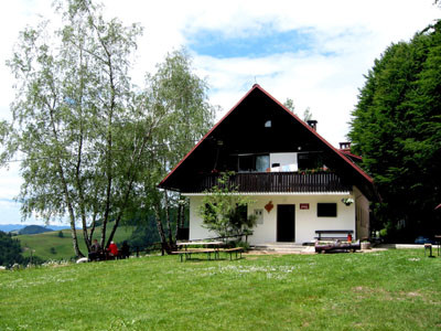
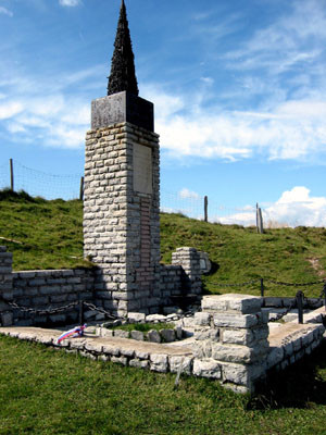
Die Hütte Ermanovec (siehe Abbildung rechts) ist sehr empfehlenswert, gute Wasch-/Duschgelegenheit (sehr sauber), nette Gastgeber, Unterkünfte sowohl Zimmer als auch Bettenlager..
Preise: Übernachtung Zimmer 18 Euro, Übernachtung Bettenlager 10 Euro, Frühstück 3 Euro. Das Frühstück ist sehr zu empfehlen!
Traduction automatique
[Google]
Après la relégation de panneaux Velbnik Sedlo mauvaises .. Nous avons trouvé le partisan hôpital Franja Bolnica utilisant uniquement un local!
Le Ermanovec façon est de nouveau bien indiqué ..
La cabine (photo à droite) Ermanovec est fortement recommandé, bon Wasch-/Duschgelegenheit (très propre), des hôtes sympathiques, hébergement et deux chambres lit de camp ..
Prix: chambre lit € 18, € 10 lit de camp pendant la nuit, petit-déjeuner € 3. Le petit déjeuner est hautement recommandé!
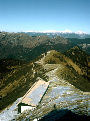
La montée au Porezen est des plus sauvages. c'est de là qu'apparait nettement le Triglav. Le refuge du Porezen est idéalement placé, surtout sa terrasse face au Triglav.

 |
5h30 |
16.9 km
|
1196 m
|
574 m
|
5h30 |
16.9 km
|
1196 m
|
574 m


Coup de cœur, critique ? Entrez votre propre commentaire sur cette étape. Pour des remarques plus générales, merci d’utiliser la fonction commentaire de la page La parole aux Via Alpinistes.