Ekskurzija (gorska pot, v časih ozka in izpostavljena)
Alpinistična pešpot (opremljena pot ali zelo izpostavljena, snežišča, skalnati bloki)
R20
Zollnersee Hütte ehm. Dr. Steinwender Hütte » Untere Valentinalm
|
6h00 |
22 km
|
818 m
|
1358 m
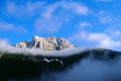
Čez planinsko območje Oberen Bischofalm nas pot vodi preko 2.167m visokega Köderkopf, kjer nas pričakuje čudovit razgled. Po vzponu gre pot navzdol čez gorske travnike in na koncu čez območja ruševja, ki so poraščena z jelšo, do planine Oberen Tschintemuntalm. Staro vojaško pokopališče ponovno dokazuje nesmiselnost vojne, v kateri ni nikoli zmagovalcev.
Od koče Dr. Steinwender Hütte sledimo markaciji proti severozahodu in pridemo do krajšega sestopa za planino Oberen Bischofalm. Od tod naprej pelje pot najprej položno navzdol, nato sledi poteku pobočja na višini od 1.500-1.600m. Po prečkanju območja izvira potoka, ki je izdolbel jarek Aßniztgrabna in teče skozi Kronhofgraben v gornjo dolino Obere Gailtal, postane pot precej strma in se povzpnemo do najvišje vzpetine te ture, Köderkopfa, z 2.167m višine (približno 3 ure). Od tod lahko uživamo ob čudovitem razgledu na vrhove območja Plöckengebiet. Podamo se strmo navzdol skozi jelševo območje, poraslo z ruševjem, in pridemo najprej do zgornje planine Oberen Tschintemuntalm in kasneje do spodnje planine Unteren Tschintemuntalm. Vzdolž potoka Angerbach pelje pot naprej po gozdni cesti. Tu se lahko odločimo za krajši izlet do pokopališč padlih junakov. Mimo jezera Grünsee dospemo do ceste Plöckenpassstraße za istoimenski prelaz in do gostilne "Plöckenhaus", ki stoji tik ob njej. Ker v gostilni ni več moč prenočiti, se povzpnemo čez Theresienhöhe in v približno 20 minutah pridemo do planine Unteren Valentinalm, kjer se nahaja planšarska koča (približno 3 ure od Köderkopfa). (Christina Schwann, OeAV)
Naravna in kulturna dediščina
Prelaz Plöckenpass predstavlja najkrajšo povezavo med Ziljsko dolino in Padsko nižino. To dejstvo so s pridom koristili že Rimljani. Planina Valentinalm je dobila ime po rimskih cesarjih Valerijanu in Valentinianu, ki sta l. 393 po Kristusu obnovila pot čez prelaz. Med 1. in 2. svetovno vojno so na območju prelaza Plöckenpass potekali hudi boji. V gostilni Plöckenhaus še danes hranijo dokumentirane posnetke o tukajšnjih vojnih grozotah. Na pokopališču padlim junakom je pokopanih skupno 1756 avstrijskih vojakov. V bližini gostišča Plöckenhaus stoji kapelica v spomin na številne padle može. Na prelazu Plöckenpass se pričenja ena izmed 5 naravoslovnih poti pohodniške poti Geo-Trail, ker so na eni od krnic na vzpetini Cellon (krnica Cellonetta) naleteli na nenavadno odkritje: V razdalji pribl. 60 m so našli kamnine iz silurija, ki jih v podobnem popolnem zaporedju sicer ne najdemo nikjer drugje v Evropi. Podlaga Cellona je sestavljena iz različno obarvanih apnencev, apnenčevih peščenjakov in skrilavcev. V kamninah ohranjeni fosili dokazujejo, da se je v plitkem morju v obdobju, daljšem od 50 milijonov let, nalagala plast za plastjo. Ti fosili so stari med 450 in 400 milijoni let. Sledijo jim še mlajši apnenci, ki segajo do vrha. Tukaj najdemo odlično ohranjene amonite (izumrli sorodniki hobotnic-op.prev.) in morske lilije v njihovi naravni velikosti. Nemoteno nalaganje in pogostost fosilov omogočata, da ta izsek nadalje razčlenjujemo in jih primerjamo s kamninami iste starosti na drugih območjih Zemlje. Zato velja to zaporedje kamnin za nekakšen standard tega obdobja, v katerem so nastajale Alpe. To posebno mesto so odkrili konec prejšnjega stoletja. Takrat so tudi ponovno do potankosti proučili tukaj ohranjene različne skupine okamnin (fosilov). Ob poti vedno znova naletimo na številke, ki označujejo odvzet vzorčni material. Tudi direktno na poti Via Alpina med planinama Spodnji Valentin in Valentin Törl hodimo po 400 milijonov let starem morskem dnu. Okamnele korale, spužve, školjke in morske zvezde lahko ugledamo na vsakem koraku. (Christina Schwann, OeAV)
Druge velike pešpoti in variante
Planinska pot Südalpiner Weitwanderweg 03, pot KGW Kärntner Grenzwanderweg. pot Geo-Trail in pot miru, rimska pot/ Römerwerg od Kötschach-Mauthen – Timau, zgodovinska pot Museumsweg od koče Plöckenhaus – Bar Langhetti; plezalna pot na poti: Kl Trieb/Pta. Medatte 2.095m , Gr. Trieb/Cuestalta 2.199m, na vrhove Frischenkofel 2.238m, Kollinkofel 2.689, pot Klabautersteig v soteski Mauthner Klamm.
Ljubezen na prvi pogled, kritika? Dodajte svoj komentar k tej etapi. Za bolj splošne opombe uporabite možnost oddaje komentarjev na strani Besede pohodnikov Vie Alpine.
flautix - 23.8.21
Eine sehr schöne Etappe bei gutem Wetter! Wege sind zum Teil sehr schmal, aber für geübte Bergwanderer mit Stöcken m. E. kein Problem. Deutlich sichtbar sind noch die Schützengräben aus dem 1. Weltkrieg oben an der Grenzlinie am Köderkopf. Wer über den Wahnsinn dieses unsinnigen Krieges in den Alpen mehr erfahren will, sollte das Museum in Kötschach-Mauten besuchen.
Untere Valentinsalm mit neuen Pächtern. Gutes Essen, nette Bedienung! Kleiner Hinweis für große Leute: die Betten in den hübschen Doppelzimmern sind nur 1,9m lang!
flautix - 23.6.6
Gute Nachrichten: es gibt jetzt neue Pächter auf der Valentinsalm und ab sofort kann wieder online gebucht werden: Birgit und Andreas Pernull, Hüttentelefon: +43 660 6799784, Mail nach wie vor: info@valentinalm.at
Der Link zur Onlinebuchung befindet sich auf der Website:
https://www.valentinalm.at/
flautix - 23.3.19
Vom derzeitigen Pächter der Valentinsalm, Bruno Neumayr, kam gestern folgende Info: Sein Pachtvertrag wurde nicht verlängert. Meine bereits bestätigte Reservierung auf der Valentinsalm für den Sommer wurde daher storniert. Buchungen sind im Moment dort offensichtlich nicht möglich! Die richtige Mailadresse der Valentinsalm lautet: info@valentinalm.at
Julien Trieste Monaco - 22.8.15
The way up to Köderkopf was clear of vegetation at the time I hiked it.
That being said, I confirm Oliver's word. This trail can be dangerous by rainy conditions. It was also pretty unpleasant despite the good weather as it was too demanding (too steep and requiring persistent attention).
Ended up at Untere Valentinalm. Owner not so friendly. 25€fpr a bed in a dorm. Camping prohibited in the valley.
Oliver - 22.7.18
Unfortunately the trail vegetation was only maintained in some areas. Large sections are hip to shoulder deep overgrown which makes seeing, hitting and staying on the trail quite difficult. In dry conditions no Problem, but since I crossed in the morning after a thunderstorm the previous night I was soaked to my underwear by the time I got to the top. The way down is also no trifle in wet conditions and sticks help immensely.
If you have little experience in the mountains or have issues with exposed trails I would advise to take an alternate route if conditions aren't ideal.
That said, the episode offers stunning views and I enjoyed it immensely, even though it requires a lot of concentration and focus for long periods of time.
Oliver - 22.7.18
Carsten's comment is a bit dramatic for my taste but there is some truth to it. The trek over the Köderkopf will take you 4-5 hours ascend+descend. Do not get caught in bad weather since there is no real alternative/escape. The trail on both sides is in parts moderately steep, narrow and in parts washed out. There are several parts where you have room for exactly one foot and since none of the broken sections have cables or reinforcements I found myself clinging at hazelnut bushes to balance through. Especially because the trail is fairly exposed at times.
Carsten - 22.1.10
Worst section of the Via Alpina so far. Except for beginning and end, the trail deteriorates into a track that is exceedingly difficult to walk. Be prepared to slip: walking sticks as support are almost a must, gloves to protect one’s hands when one slips, long pants as protection against the undergrowth (and stinging nettles at one place on the descent). Much of the difficult track consists of crossing steep slopes, plus a steep descent. The scenery does not warrant this painful track. The vegetation suggests that this is a particularly rainy corner. Halfway down the descent, the signposted trail diverges from the GPS (and the trail indicated by the GPS coordinates no longer exists).
Alternative: Consider descending from the Zollnersee Huette (beginning of R20) to the town of Mauthen to resupply (Maps.me will display a walking route) and then returning to (almost) the end of R21(?) on a small road that runs parallel to (though distant from) the main road (or check for a bus).
POPEYE GG - 18.6.13
25 juin 2017
Compte tenu des prévisions de mauvais temps, et du besoin d'argent liquide (en Autriche rarement possible de payer en carte bleue, même parfois dans les hôtels en plaine!), j'ai quitté momentanément la Via Alpina et suis descendu sous la pluie battante sur Mauthen (très touristique et cher) puis le village voisin Kötschach. J'y ai trouvé un hôtel qui reçoit aussi des groupes de motards, mais qui n'accepte pas la carte Visa.
Le temps est redevenu beau à l'arrivée!
Samodejni prevod
[Google]
25. junij 2017 Glede na napoved slabega vremena in potrebo po gotovini (v Avstriji je le redko mogoče plačati z modro karto, tudi včasih v hotelih v nižinah!), Sem začasno zapustil Via Alpino in šel dol v nalivnem dežju na Mauthen (zelo turistično in drago) nato sosednjo vas Kötschach. Našel sem hotel, ki sprejema tudi biker skupine, vendar ne sprejema kartice Visa. Vreme je ob prihodu spet lepo!
After Plöckenhaus the marked trail differs from the GPS track. I believe the GPS track follows an unpaved road while the hiking path is really nice. So just follow the signs. Very friendly people at Zollnersee Hütte and good coffee :-). The hüttewirt doesn't want you to camp, but as long as you're or of sight, it's allright. I camped on the parking lot, because there were cows everywhere and the grass is quite wet.
Samodejni prevod
[Google]
Po Plöckenhausu se označena pot razlikuje od poti GPS. Menim, da sledi GPS sledi neasfaltirani cesti, medtem ko je pohodna pot zelo dobra. Samo sledite znakom. Zelo prijazni ljudje na Zollnersee Hütte in dobra kava :-). Hüttewirt ne želi, da taboriš, toda dokler si ali vidiš, je vse v redu. Taboril sem na parkirišču, ker so bile krave povsod in trava je precej mokra.
Bumbum - 15.8.3
Auf dieser Etappe ist die Mitnahme eines Leathermans empfohlen um den dreifach über den Weg gespannten, bereits unzählige Male geflickten, Stacheldrahtzaun am Waldrand oberhalb der Unteren Tschintemuntalm zu durchtrennen – als symbolischer Akt gegen Grenzen und gegen Krieg an diesem geschichtsträchtigen Ort.
Samodejni prevod
[Google]
Na tej stopnji, nosite Leatherman je s triple Priporočljivo je na poti napeti, neštetokrat krpar rezanje bodeče žice ob robu gozda nad spodnjo Tschintemuntalm - kot simbolno dejanje zoper mejah in proti vojni na tem zgodovinskem mestu.
tof - 14.12.25
Trieste- Monaco le 13/7/14
Belle étape alpine d'un point de vue historique. Pas de ravitaillement sur le parcours. A gite Untere Valentinalm possibilité d'acheter barres de chocolat. Bivouac en forêt un peu avant d'arriver sur le gîte.
Samodejni prevod
[Google]
Trst Monaco na 07/13/14 Lepa alpski fazi v zgodovinski perspektivi. Menjave goriva na progi. Koči Untere Valentinalm priložnost za nakup čokolade. Bivak gozd tik pred prihodom v koči.
Brido - 13.3.31
Wir haben festgestellt, dass Ihr Wegzeitberechnungen nicht stimmen. Die Hüttenwarte geben bis zu 50% mehr Zeitbedarf an. Auch die Berechnungen nach DIN oder den Richtlinien des SAC ergeben viel mehr Zeitbedarf. Können Sie Ihre Zeit überprüfen. Danke für eine Info.
Samodejni prevod
[Google]
Zaznali smo, da vaš Wegzeitberechnungen ne strinjajo. So oskrbniki kažejo tudi do 50% več časa je potrebno. Prav tako so bili izračuni v skladu z DIN oziroma smernicami iz SAC dajejo veliko bolj zamudno. Lahko preverite svoj čas. Hvala za info.
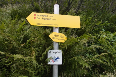
Passage de l’itinéraire jaune à l'itinéraire rouge: A Tolmezzo (B12-B13), prendre le bus pour Timau à la station centrale. A Timau, suivre le sentier 402 qui monte à Casera (2h). Continuer sur la piste (402) et après 700m prendre à droite le petit sentier qui monte sur la crête frontière "Cra Pramosio" (15 min). Prendre le sentier qui descend direction nord-ouest :il rejoint l'itinéraire rouge (R20) en 20 minutes. Il y a un panneau de la Via Alpina à la jonction. (entre Köderkopf et Obere Bischhofalm).
Le passage de l’itinéraire rouge à l'itinéraire jaune est aussi facile.
Samodejni prevod
[Google]
Rumena pot skozi rdečo pot: Tolmezzo (B12-B13), z avtobusom do centralne postaje Timau. Timau sledimo poti, ki se vzpenja do 402 planine (2h). Nadaljuj na stezi (402) in po 700m zavijemo desno v majhno pot, ki se vzpenja po grebenu mejo "Cra Pramosio" (15 min). Bodite pot navzdol severozahodni smeri: je pridružil Rdeča pot (R20) v 20 minutah. Obstaja panel Vii Alpini na križišču. (Med Köderkopf in Obere Bischhofalm). Prehod iz rdeče v rumeno progo poti je lažje.
The dorms of the Valentin Gasthof are in a separate building. At night they locked the outside door, and in the morning we had to shout out the window to get us freed!
HP 36 euro.
Samodejni prevod
[Google]
Dorms Valentin Gasthof so v ločeni zgradbi. Ponoči so zaklenjena zunaj vrata, in zjutraj smo morali Vikati okno zadobiti nas sproščena!
HP 36 evrov.

 |
6h00 |
22 km
|
818 m
|
1358 m
|
6h00 |
22 km
|
818 m
|
1358 m


Ljubezen na prvi pogled, kritika? Dodajte svoj komentar k tej etapi. Za bolj splošne opombe uporabite možnost oddaje komentarjev na strani Besede pohodnikov Vie Alpine.