Passeggiata / turismo (sentiero largo non esposto)
Escursione (sentiero di montagna, a volte stretto ed esposto)
Escursione alpina (passaggio attrezzato o molto esposto, nevaio, blocchi rocciosi)
R49
Weißenbach am Lech » Prinz-Luitpold-Haus
Collegamento itinerario
|
8h30 |
26.8 km
|
1429 m
|
474 m
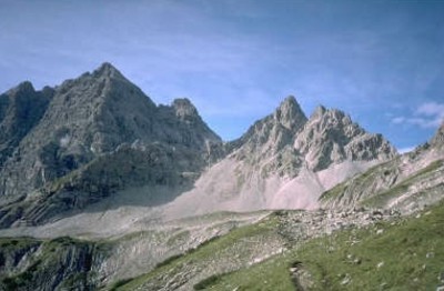
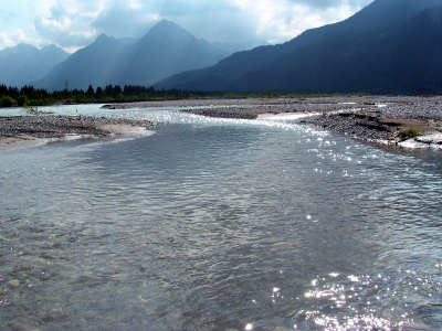
La valle tirolese Lechtal, l’ultimo grande paesaggio fluviale selvaggio in Europa, zona Natura 2000 e futuro parco nazionale domina questa tappa. Lasciandosi alle spalle le distese di ghiaia del fiume Lech, si passa per pittoreschi boschi lungo il fiume seguendo l’andamento della valle Schwarzwassertal, il portale verso i monti dell’Allgäu, dove la vetta Hochvogel troneggia su tutte le altre.
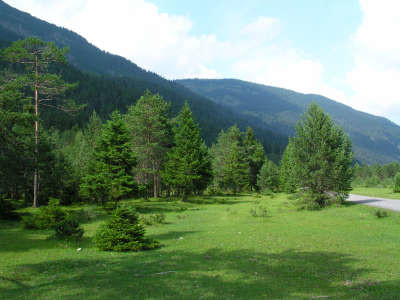
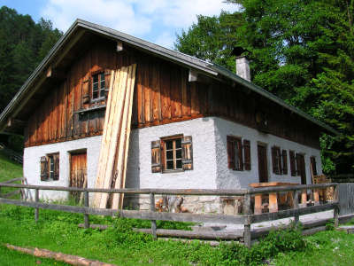
A Weißenbach si segue la strada, si passa davanti alla chiesa e all'ufficio postale, e ci si tiene sulla sinistra seguendo le indicazioni della pista ciclabile, che passa sotto la strada statale e presso la piscina svolta a destra. Dopo un breve tratto su una stretta strada sterrata si rsggiunge la pista ciclabile vera e propria e la si segue lungo la riva del fiume Lech. Tra gli alberi si intravede il paesaggio fluviale selvaggio e romantico, l'acqua turchese e le rive di ghiaia bianca. Al bivio si può sceglier di fare una deviazione al lago Baggersee, meta di gite per turisti e locali, dove d'estate si può anche fare il bagno. Subito prima del ponte Johannesbrücke, si seguono le indicazioni per Vorderhornbach. Si passa sotto il ponte e alla strada principale e ci si tiene a destra. La vista sul Lech è stupenda. Un tabellone presenta e spiega tutte le particolarità di questo paesaggio unico che rientra nel progetto europeo Natura 2000. Seguendo la strada sterrata, si arriva alla stretta strada asfaltata, si prende a sinistra e ci si addentra nella valle. Vale la pena fare una piccola deviazione verso il ponte sospeso più in basso che porta a Forchach per godere un particolare panorama. Si continua per la pista ciclabile e si arriva a Geisterstein e ad una piccola fontana. Il sentiero porta al bel pianoro di Radsperrboden, percorso da molti corsi d'acqua, che sembra quasi un parco. Si raggiunge subito la casa di caccia e si attraversa infine il ponte sul ruscello Scharzwasserbach. Subito dopo, la strada forestale svolta a destra nella valle Schwarzwassertal, disabitata e coperta di fitti boschi, dove si procede in leggera salita fino a raggiungere l'alpe Jagdhüttenalm. Si segue poi il sentiero attraverso il bosco Saldeiner Wald, si taglia il versante nord del selvaggio gruppo del Roßzahn, fino ad attraversare nuovamente il rio Schwarzwasserbach prima di arrivare al rifugio Eibleshütte (3h40min). Alla fine della strada forestale presso il rifugio Fuchswaldjagdhütte inizia uno stretto sentiero, segnalato, che porta all'alpe Obere Lichtalpe. Seguendo il sentiero in salita, s'incontra un altro sentiero che taglia il pendio e lo si prende a destra. Passata la Casa del Soccorso Alpino ci si trova sullo Jubiläumsweg e anche sul sentiero Viola della Via Alpina. Il sentiero Rosso ed il sentiero Viola continuano insieme, a sinistra, tra i monti Glasfelderkopf e Kesselspitze salendo ripidamente fino alla forcella Bockkarscharte. Sull'altro versante della forcella il sentiero scende, meno ripido, fino al rifugio Prinz-Luitpold-Haus (4h30min dal rifugio Eibleshütte). (Christina Schwann, OeAV)
Patrimonio naturale e culturale
Le estese superfici di ghiaia scarsamente popolate lungo il Lech sono l’espressione non di un fiume "degenerato", né sono pericolose o inutili, bensì l’opera della dinamica fluviale. Numerose specie vegetali e animali dipendono da tale dinamica. Tra questi la myricaria germanica e il corriere piccolo. Questo uccellino cova sulle superfici ghiaiose e si procura il cibo nei depositi sulle sponde. Le zone coperte di boscaglia non sono idonee come posto di cova. Sul sentiero da Weißenbach fino al ponte Johannesbrücke si possono ammirare i ginepri con sembianze di veri e propri alberi, che raggiungono addirittura i 10m e sono senza eguali nell’intero Tirolo. Sin dal 1970 sono stati profusi sforzi per mettere sotto protezione alcuni tratti del Lech con le loro praterie. I progetti dell’associazione ambientale "Verein für Heimatschutz und Heimatpflege in Tirol" non sono stati realizzati a causa dei notevoli interessi legati allo sfruttamento dell’energia elettrica. La società Elektrizitätswerke Reutte aveva in programma la realizzazione di una decina di nuove centrali, la prima sul torrente Streimbach, immissario del Lech, classificato dagli esperti come ambiente unico in virtù delle numerose isolette di ghiaia e conche con Knorpellattich-, Alpenpestwurz- und Lavendelweidengesellschaften, nonché delle zone stabili con la grande biodiversità dei loro boschi di pini. La costruzione di queste centrali non soltanto avrebbe privato il Lech dell’apporto di detriti solidi, ma avrebbe anche distrutto gli abitanti delle sue sponde a causa dei getti d’acqua che le avrebbero investite più volte al giorno. In seguito all’incanalamento di grandi quantità d’acqua sarebbero venute meno le esondazioni sui banchi di ghiaia, con una conseguente crescita di cespugli, che avrebbe allontanato le specie animali e vegetali dipendenti da questo tipo di habitat per la loro sopravvivenza. La popolazione tirolese si oppose giusto in tempo al progetto della centrale idroelettrica, mentre parallelamente emerse l’idea di un parco nazionale. Mentre procedevano le discussioni sul parco nazionale, il Lech venne registrato presso l’Unione europea come zona Natura 2000, certamente un primo passo nella direzione giusta. Il parco nazionale, però, sarebbe stato di grande interesse dal punto di vista turistico per la zona poco conosciuta di Außerfern. Purtroppo non venne mai realizzato. In una votazione i sindaci della valle del Lech votarono contro il parco nazionale e a favore del Parco Naturale Fluviale "Wildflusslandschaft Tiroler Lechtal", la cui continuazione è l’area naturale protetta "Allgäuer Hochalpen". La creazione di quest’area viene prescritta in un ordinamento del governo svevo del 24.01.1992 e persegue la tutela della straordinaria bellezza, ricchezza, particolarità e tranquillità nella sua interezza. Qualsiasi intervento dell’uomo sotto forma di realizzazione di nuove strade, edifici o impianti di risalita e piste da sci è pertanto vietata. Il potenziale naturalistico deve essere preservato per le generazioni future. (Christina Schwann, OeAV)
ÖK 50 115, 114 ~ Bundesamt f. Eich- u. Vermessungswesen (1:50.000)
Galleria foto
Aggiungi le tue foto!
Commenti
Una gradita sorpresa, una critica? Inserite il vostro commento personale su questa tappa. Per osservazioni più generali, utilizzate la funzione commento della pagina La parola ai Via Alpinisti.
Thorsten - 13/09/22
On the route to Forchach we recommend not staying on the bicicle road. Instead, right after the Lechsteg (near the public swimming pool), take the small footpath to the left, which is very quiet and right by the Lech, and passes some interesting private leisure huts that are open to the public!
We can confirm what Piet Clerinx wrote about the path above the Obere Lichtalpe. It is not really visible any more, so we too had to use the GPS track.
Piet Clerinx - 04/08/22
Between the Obere LichtAlpe and the path crossing the slope at about 1800m there is no track anymore, let alone way markings or signposts. You have to search your way up. Luckily I had the gpx of this route downloaded on my smartphone, so I knew where they trail was supposed to be.
POPEYE GG - 03/02/19
Mardi 26 juin 2018
Longue étape avec grande marche d'approche le long du Lech. La deuxième moitié de la montée est plus difficile, d'autant qu'il y a encore de la neige avant d'arriver à la Bockkarscharte, où nous avons pu admirer des chamois.
Traduzione automatica
[Google]
Martedì 26 giugno 2018 Lunga tappa con grande passeggiata lungo il Lech. La seconda metà della salita è più difficile, soprattutto perché c'è ancora neve prima di arrivare al Bockkarscharte, dove potremmo ammirare i camosci.
Martin - 15/08/18
Die Warnung von Tentorini Chantal muss man nicht berücksichtigen, da man sich am Trinkasserbrunnen auf der Terasse des Prinz-Luitpold-Hauses jederzeit kostenlos Wasser abfüllen kann.
Bei schwierigen Wetterverhältnissen erhielten wir kompetente Informationen zum Wetter und Weg vom Hüttenpersonal.
Traduzione automatica
[Google]
L'avvertimento di Tentorini Chantal non è necessario tenerne conto, perché al Trinkasserbrunnen sulla terrazza della casa Prinz-Luitpold puoi sempre riempire l'acqua in qualsiasi momento. In condizioni meteorologiche difficili abbiamo ottenuto informazioni competenti sul tempo e sulla via del personale del rifugio.
I hiked via Brocksee and Landsberger Hütte, probably on the purple trail (?). Beautiful panorama route, a few small "climbs," with steel cables, very good views. Not much water though.
Traduzione automatica
[Google]
Ho fatto un'escursione via Brocksee e Landsberger Hütte, probabilmente sulla pista viola (?). Bellissimo percorso panoramico, alcune piccole "salite", con cavi d'acciaio, viste molto buone. Non c'è molta acqua però.
The track to the Bockkarscharte is hard to find. Grass has overgrown it, and cows made their own alternative tracks. But the GPS track is quite good here, use it and you will be OK. Watch the memorial on the Scharte, erected for an officer in 1939; with a nazi symbol still clearly visible.
Traduzione automatica
[Google]
La traccia per il Bockkarscharte è difficile da trovare. L'erba è cresciuta troppo e le mucche hanno creato le loro tracce alternative. Ma la traccia GPS è abbastanza buona qui, usala e sarai OK. Guarda il memoriale sullo Scharte, eretto per un ufficiale nel 1939; con un simbolo nazista ancora chiaramente visibile.
Tentorini Chantal - 25/09/15
Attention, le verre d'eau du robinet est facturée à 2,50 € au refuge Prinz Luitpold. Voilà un prix bien royal pour un verre d'eau!!!
Traduzione automatica
[Google]
Attenzione, il bicchiere d'acqua di rubinetto è addebitato a 2,50 € al rifugio Prinz Luitpold. Si tratta di un prezzo molto reale per un bicchiere d'acqua !!!
Michael - 21/08/13
If you are walking from Prinz Luitpold Haus to Weissenbach be aware that the point where the red trail leaves the purple trail is not signposted. To find it, look for a rock with the letters "P.L.H." and an arrow pointing the way you came. That is to tell walkers going the other way where Prinz Luitpold Haus is. The trail is not clear on the ground but you should soon see red marks on rocks identifying it.
Traduzione automatica
[Google]
Se siete a piedi da Prinz Luitpold Haus a Weissenbach essere consapevoli che il punto in cui il sentiero rosso lascia il sentiero viola non è segnalato. Per trovarlo, cercare una roccia con le lettere "PLH" e una freccia che indica il modo in cui siete venuti. Vale a dire gli escursionisti che vanno nella direzione opposta in cui Prinz Luitpold Haus è. Il sentiero non è chiaro a terra ma si dovrebbe presto vedere segni rossi sulle rocce che lo identifica.
Elisabeth - 29/12/12
Je confirme : le sentier est très mal indiqué dès le début, même si, de loin en loin, on voit un signe de la Via Alpina. Cela empire après la dernière barrière. La première mention du refuge Prinz Luitpold se trouve au niveau de Bergwarchthütte (!) et encore il s'agit d'un poteau cassé posé par terre dont l'écriteau aurait dû se trouver à la jonction avec le sentier Jubiläumsweg !
Traduzione automatica
[Google]
Confermo: il sentiero è molto mal segnato fin dall'inizio, anche se di tanto, si vede un segno della Via Alpina. C'è di peggio, dopo l'ultima barriera. La prima menzione di rifugio Prinz Luitpold si trova a Bergwarchthütte (!) E tuttavia è un palo rotto che giaceva a terra che il bando avrebbe dovuto essere al bivio con il sentiero Jubiläumsweg!
Alpinisten - 24/09/12
Der Weg ab der Oberen Lichtalpe Richtung Prinz-Luitpold-Haus ist schlecht markiert. Für diese Etappe in Weißenbach gut mit Proviant eindecken, unterwegs keine Einkehrmöglichkeit.
Traduzione automatica
[Google]
Il percorso della luce superiore Alpe direzione Prinz Luitpold casa è mal segnalato. Per questa fase in Weissbach ben scorta di forniture, su strada non bevande rinfrescanti.
Margy - 07/02/12
25/6/11 Long hike to Prinz-Luitpoldhaus...the final pass in protected by cables and steps. The hut is very well organized and very crowded. Many gemsen near the pass.
Traduzione automatica
[Google]
25/6/11 lunga escursione a Prinz-Luitpoldhaus ... il passo finale protetto da cavi e gradini. Il rifugio è molto ben organizzata e molto affollata. Gemsen Molti vicino al passo.
Ulrich Aellig - 14/07/09
Was sollen denn die blauen Dreiecke (Gipfel)? Es sieht jan ein blinder mit dem Stock vom Schiff aus, dass es sich nicht um Gipfel handeln kann.
Traduzione automatica
[Google]
Quali sono allora i triangoli blu (in alto)? Sembra gennaio un cieco con un bastone dalla nave, che non può agire verso l'alto.

 |
8h30 |
26.8 km
|
1429 m
|
474 m
|
8h30 |
26.8 km
|
1429 m
|
474 m


Una gradita sorpresa, una critica? Inserite il vostro commento personale su questa tappa. Per osservazioni più generali, utilizzate la funzione commento della pagina La parola ai Via Alpinisti.