Passeggiata / turismo (sentiero largo non esposto)
Escursione (sentiero di montagna, a volte stretto ed esposto)
Escursione alpina (passaggio attrezzato o molto esposto, nevaio, blocchi rocciosi)
R38
Finkenberg » Rastkogelhütte
|
7h15 |
22.4 km
|
1980 m
|
701 m
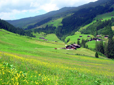
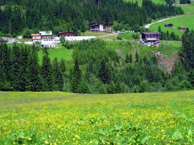
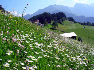
Dopo due tappe piacevoli ne segue ora una più lunga, la cui meta è il rifugio Rastkogelhütte a 2.117m. All’inizio il sentiero sale sui fianchi del monte Penken. Attraversando piccoli insediamenti, prati e boschi si giunge alla frazione Morbach, da dove inizia la salita al rifugio Rastkogelhütte.
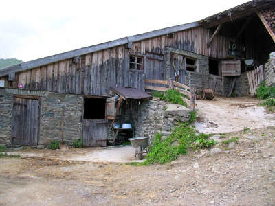
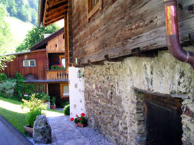
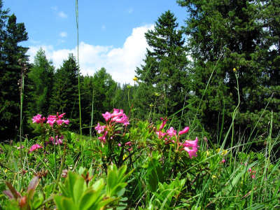
A Finkenberg la Via Alpina passa proprio davanti all'entrata principale della chiesa. Qui seguire il segnavia in direzione Astegg. Dopo un breve tratto in salita sulla strada asfaltata prendere il sentiero a sinistra. Seguire il 25; c'è anche la possibilità di prendere il sentiero Maienweg o il sentiero della cascata Wasserfallweg, che conducono alla stessa meta. Il sentiero sale attraverso il bosco e prati, sbucando proprio davanti all'entrata della locanda Gasthof Gletscherblick, che invita ad una merenda. Salire la scala e tenendosi sul lato destro della strada, si continua a seguire il sentiero 25. Ora si segue un tratto di strada asfaltata che offre una magnifica vista su Finkenberg e sull'intera valle Zillertal più interna. Non è consigliabile salire attraverso i ripidi prati! Dopo numerosi tornanti si arriva in ca. 1h alla locanda Gasthof Astegg. Qui si trova una fonte cui è possibile rifornirsi d'acqua prima di affrontare la ripida salita al Penken. Proprio vicino alla fattoria Hof Oberegger il sentiero sale a sinistra fino al tornante della strada. Da questo momento seguire il sentiero 2 in direzione Penken e Gschößwand. Ancora si segue un tratto di asfalto, che dopo il secondo tornante si trasforma in strada bianca. Appena iniziata la strada sterrata, sulla sinistra, si diparte un sentiero nel bosco. Seguendolo si sale attraverso un bosco più o meno fitto, incrociando più volte la strada forestale. Infine si arriva ad una recinto per bestiame e il sentiero prosegue attraverso alpeggi fino alla stazione del Penken Express. Continuando a destra sulla strada asfaltata sotto alla funivia Penkenbahn si arriva alla locanda Gasthof Gschößwand, dalla cui splendida posizione si gode una magnifica vista sullo scenario delle montagne e sulla valle Zillertal (1h40min). Da qui si segue il sentiero 24 che, partendo dalla locanda Gasthof Gschößwand va verso sinistra un po' in salita per continuare immediatamente a destra. All'inizio quasi pianeggiante per bei prati con molti rododendri e pini cembri, scende poi per un tratto abbastanza ripido e umido, per poi continuare a scendere più dolcemente in un bosco più fitto. Dopo ca. 30min si arriva ad una strada forestale, si attraversa e si continua per il sentiero fino a giungere a Mösl (1h10min). Nel paese di Mösl si può pernottare nella locanda Alpengasthof Mösl, volendo rimandare al giorno dopo la salita al rifugio Rastkogelhütte percorrendo il circuito degli alpeggi. Volendo proseguire invece, da Mösl si continua sulla strada rotabile in direzione del rifugio Rastkogelhütte. Il sentiero da seguire porta i numeri 18 e 302A. Si segue la strada fino all'alpe Pointalm, molto caratteristica. Poi si prosegue su un sentiero dietro all'alpe, che sbocca ben presto sulla forestale diretta al rifugio Rastkogelhütte, meta della tappa (2h30min). . (Christina Schwann, OeAV con cortese aiuto di Gudrun Wallentin, Hochgebirgs-Naturpark Zillertaler Alpen)
Patrimonio naturale e culturale
Il paesino di Finkenberg presenta varie attrattive. Ad esempio il Ponte del Diavolo sul rio Tuxerbach, che si attraversa andando da Karlsteg a Finkenberg. Secondo la leggenda, i contadini di Finkenberg riuscirono a beffare il diavolo in persona. Gli fecero costruire il ponte promettendogli in cambio il primo essere vivente che lo avesse attraversato. Quando il ponte fu terminato, gli mandarono incontro un caprone. Il diavolo, furibondo, afferrò l'animale per le corna e fuggì sulla sua groppa. Anche un'altra orribile storia gira per il paese: la terribile storia dello "Zingerle". Questo personaggio fu un famoso assassino di donne, colpevole di stupri e omicidi per i quali alla fine fu anche condannato. Si racconta però che evase dalla prigione e si nascose in una grotta nel bosco Jochberger Wald, proprio sopra al sentiero che porta da Karlsteg a Finkenberg. In Tirolo diventò una leggenda che incuteva terrore. Un'insegnante di Brunico racconta: "Mia nonna materna usava dire a mia madre: "Attenta quando vai nel bosco, ti può prendere lo Zingerle"". Nei tempi andati era il turismo estivo ad essere importante per la Zillertal e specialmente per Mayrhofen, oggi invece è il turismo invernale che la fa da padrone. Montagne e ghiacciai sono state attrezzati con moderni impianti di risalita, come al Penken. Famosi sciatori, come Stefan Eberharter e Markus Kröll, sono originari della valle e si allenano di preferenza sulle montagne natie. (Christina Schwann, OeAV, Gudrun Wallentin, Hochgebirgs-Naturpark Zillertaler Alpen)
Altri grandi itinerari e varianti
Dal rifugio Rastkogelhütte passando per il Weidener Hütte, il Lizumer Hütte, il Glungezer Hütte e il Patscherkofel-Schutzhaus si può camminare fino a Innsbruck, la sede del Segretariato permanente della Convenzione delle Alpi. Da lì, passando per il rifugio Pfeishütte e il Hallerangerhaus, si può arrivare al rifugio Karwendelhaus o direttamente a Scharnitz (tappa R43).
Una gradita sorpresa, una critica? Inserite il vostro commento personale su questa tappa. Per osservazioni più generali, utilizzate la funzione commento della pagina La parola ai Via Alpinisti.
Carsten - 10/01/22
Water at Pfundsalm, Lamarkalm, and Maschentalalm.
The guidebook includes the 2-hour ascent to the Kellerjochhuette in both R39 and R40.
Carsten - 10/01/22
(2) No water at Rastkofelhuette; possibilities before and after (some judgment required as to quality).
Highline / ridge trail alternative from Finkenberg: Take Finkenberger Almbahn (gondola) to the very top (Penkenjochhaus) and continue from there via the Rastkogel to the Rastkogelhuette. Maps.me has the trail with 4 hours 33 minutes, 13km and 704m of elevation gain (and a similar elevation loss in the diagram); I would probably double-check in Finkenberg as to the difficulty; as far as I can tell from looking at the Rastkogel (peak), it’s not difficult.
Carsten - 10/01/22
(1) In sunny weather, the first climb of the day in the morning up a South-East facing hillside is nicely warm, and after the descent the second climb of the day in the afternoon up a West-facing hillside is also nicely warm.
I took the Finkenberg gondula to its Mittelstation (first leg only) and then walked over (100m elevation gain, then level, then down) to the Penken Bahn station, where I joined R38 after a 5min descent; total walking time 1 hour. This was the only worthwhile hiking that I experienced in the Zillertal.
Rerouting of trail to Moesl, different from guidebook/GPS coordinates (also from AllTrails map), with original trail seemingly under nature restoration. This means a descent to 1327m before ascending towards Moesl (with another short descent in the 15min before Moesl).
sennburk - 06/07/20
strBis zum Gschösswandhaus ist der Weg recht einfach zu finden-danach wird es mit der Orientierung schwieriger - gleich beim Gschößwandhaus rechts zum Steig Richtung Mösl- man kann auch am Weg Nr. 24 bleiben über die Kressbrunnalm nach Mösl gelangen. Almhof Roswitha lädt zu einer Jause ein. Danach über herrliche Almböden zur Rastkogelhütte. Schiane Griaß Burki
Lolo - 29/07/19
Bonne montée de 1000m pour commencer puis redescente à Mosl avant de remonter 700 m vers le refuge Raskogelhütte. Balisage moyen pas continu de bout en bout. Arrivé à 14h , je poursuis sur Hochfügen en 2h de descente. Peu d'hebergement ...Hotel Berghotel superbe. 1/2 pension 89€.
Traduzione automatica
[Google]
Buona salita di 1000 m per iniziare poi fino a Mosl prima di salire 700 m verso il rifugio Raskogelhütte. Markup medio non continuo da un capo all'altro. Arrivato alle 14h, continuo su Hochfügen in 2h di discesa. Piccolo alloggio ... Hotel Berghotel eccezionale. 1/2 pensione 89 €.
Die Rastkogelhütte ist leider nicht zu empfehlen. Die Gastwirte sind sehr unfreundlich und diese Unfreundlichkeit macht sich im ganzen Haus bemerkbar.
Da wir in der Hütte nichts verzehrt, sondern uns draußen selbst versorgt hatten, mussten wir pro Person 5,- „Infrastrukturbeitrag“ zahlen, worauf wir vorher nicht hingewiesen wurden.
Ich kann den Grundgedanken verstehen, dass ein Konsum in der Hütte gewünscht wird, allerdings kann dies auch anders und netter kommuniziert werden.
Wir haben uns hier rundum unwohl und nicht willkommen gefühlt.
Traduzione automatica
[Google]
Purtroppo il Rastkogelhütte non è raccomandato. I padroni di casa sono molto scortesi e questa scortesia si fa sentire in tutta la casa. Poiché non avevamo consumato nulla nella capanna, ma ci eravamo presi cura di noi stessi, dovevamo pagare 5 persone a titolo di "contributo infrastrutturale", che non eravamo stati precedentemente informati. Riesco a capire l'idea di base che si desidera un consumo nella capanna, ma questo può anche essere comunicato in modo diverso e migliore. Ci siamo sentiti a disagio e sgraditi qui.
POPEYE GG - 01/02/19
Et bien non, c'était le 15 juin!
Traduzione automatica
[Google]
Beh no, era il 15 giugno!
POPEYE GG - 01/02/19
Désolé, il fallait lire 5 juin 2018, et non 5 juillet!
Traduzione automatica
[Google]
Siamo spiacenti, abbiamo dovuto leggere il 5 giugno 2018, non il 5 luglio!
POPEYE GG - 01/02/19
5 juillet 2018
C'est reparti pour 2018! Objectif cette année: Scuol (R66). Nous sommes 3 avec André et Thierry.
Bonne 1ère étape: 1900m de montée et 700m de descente, au bout de laquelle on a failli ne pas pouvoir être hébergés à la Rastkogelhütte, pour cause de fin de travaux... mais ça c'est arrangé!
Voir aussi mon blog "vivelaretraitesurlaviaalpina.blogspot.com"
Traduzione automatica
[Google]
5 luglio 2018 Torniamo al 2018! L'obiettivo di quest'anno: Scuol (R66). Siamo in 3 con André e Thierry. Buona prima tappa: 1900m di salita e 700m di discesa, alla fine della quale quasi non potevamo essere alloggiati al Rastkogelhütte, a causa della fine dei lavori ... ma che è sistemata! Vedi anche il mio blog "vivelaretraitesurlaviaalpina.blogspot.com"
Brigitte Duquesnay - 24/09/18
Nous avons été très mal accueillis à Rastkogelhütte. Comme il pleuvait et que le temps était bouché, nous avons pris un bus pour éviter de marcher 8h sans rien voir. Nous sommes arrivés vers 13H et avons demandé s'il était possible de manger notre piquenique à l'intérieur en ne commandant qu'une soupe. Il nous a été répondu que ce n'était possible que si nous étions du Club Alpin. Nous étions 3 mais 2 seulement avaient leur carte du club alpin français. Nous n'avons pas voulu laisser l'un d'entre nous manger seul dehors sous la pluie. Donc nous n'avons pas commandé de soupe et avons attendu 15H pour avoir notre place en dortoir. (nous avions réservé 3 demi-pensions et payé 15€ d'arrhes par personne). La gardienne de ce refuge était particulièrement désagréable et nous avons appris le lendemain qu'un couple du club alpin allemand ayant réservé la demi-pension avait été enregistré 2 fois. La gardienne n'a pas voulu leur rembourser les arrhes payés 2 fois...
Traduzione automatica
[Google]
Siamo stati ricevuti molto male al Rastkogelhütte. Mentre pioveva e il tempo era intasato, abbiamo preso un autobus per evitare di camminare 8 ore senza vedere nulla. Siamo arrivati intorno alle 13.00 e abbiamo chiesto se era possibile mangiare il nostro picnic al chiuso ordinando solo una zuppa. Ci è stato detto che questo era possibile solo se fossimo nel Club Alpino. Eravamo 3 ma solo 2 avevano la loro carta di club alpino francese. Non volevamo permettere a nessuno di noi di mangiare da solo sotto la pioggia. Quindi non abbiamo ordinato la zuppa e abbiamo aspettato 15 ore per il nostro posto nel dormitorio. (Abbiamo prenotato 3 trattamenti di mezza pensione e pagato 15 € per ogni persona). Il guardiano di questo rifugio era particolarmente sgradevole e il giorno seguente abbiamo appreso che un paio di club alpini tedeschi che avevano prenotato la mezza pensione erano stati registrati due volte. La babysitter non ha voluto rimborsare il deposito pagato due volte ...
The GPS track is not matching the signposts. According to the track there should be an hiking path through the forest which is much shorter and avoids the road. Unfortunately I couldn't find it, I think it is not marked (yet).
Traduzione automatica
[Google]
La traccia GPS non corrisponde ai segnali stradali. Secondo la traccia ci dovrebbe essere un sentiero attraverso la foresta che è molto più breve ed evita la strada. Purtroppo non ho potuto trovarlo, penso che non sia segnato (ancora).
Having lost too much time, I had to go to Waldhaus Mösl. The dorms are for children groups only. Private room €50HP. It is a very chaotic place, when I entered my room I found it was already occupied. Then the warden inspected all the other rooms to finally find one that was empty. Also the food is very poor. I went to bed hungry. Not recommended.
Traduzione automatica
[Google]
Avendo perso troppo tempo, dovevo andare a Waldhaus Mösl. I dormitori sono solo per gruppi di bambini. Stanza privata € 50HP. È un posto molto caotico, quando sono entrato nella mia stanza ho scoperto che era già occupato. Quindi la guardia ispezionò tutte le altre stanze per trovarne finalmente una vuota. Anche il cibo è molto povero. Sono andato a letto affamato. Non consigliato.
After Penken, just after another ski-lift, you will find the passage through the valley of the Horbergbach is closed. Walk up the valley until you reach a most horrible deserted ski-resort, pass the closed Eisberghutte, ignoring the 'Hikers strictly forbidden' sign, and climbing a barb-wire fence, to return on the other side of the valley. The road ends up in a meadow. Climb up to the asphalted road, and follow that down.
Traduzione automatica
[Google]
Dopo Penken, subito dopo un altro impianto di risalita, troverete che il passaggio attraverso la valle di Horbergbach è chiuso. Risalire la valle fino a raggiungere una stazione sciistica più orribile e deserta, oltrepassare la chiusa Eisberghutte, ignorando il cartello "Escursionisti severamente vietato" e arrampicandosi su un recinto di filo spinato, per tornare dall'altra parte della valle. La strada finisce in un prato. Sali fino alla strada asfaltata e seguila.
Penken is a depressing place. The top station is a huge squarish building with a shopping mall inside. Surroundings are flattened by a bulldozer to comfort the skiers, thereby burying the Via-Alpina track. Find the track by going to the closed down gasthof between the two cable-stations, go underneath a bridge and on the back of that house you will find a road-sign.
Traduzione automatica
[Google]
Penken è un posto deprimente. La stazione a monte è un'enorme costruzione quadrata con all'interno un centro commerciale. I dintorni sono appiattiti da un bulldozer per confortare gli sciatori, così da seppellire la traccia Via-Alpina. Trova la pista andando al chiuso gasthof tra le due stazioni della funivia, vai sotto un ponte e sul retro di quella casa troverai un cartello stradale.
gianadda marie-jo - 17/08/15
Sommes descendues directement sur Mayrhofen. Grande station, pleine de monde....Départ en train pour Innsbruck (fin de Via Alpina pour nous)
Traduzione automatica
[Google]
Discendono direttamente a Mayrhofen. Ottimo villaggio, pieno di gente .... Partenza in treno a Innsbruck (fine della Via Alpina per noi)
Elisabeth - 24/12/12
Etape très longue et très mal balisée ! Beaucoup de route goudronnée. Heureusement, une dame m'a prise en stop et rapprochée de Mösl. De là, il faut encore marcher pendant 5 km sur la route avant de trouver la piste qui mène à Rastkogelhütte.
Traduzione automatica
[Google]
Molto lungo e mal segnalato Passo! Molti strada asfaltata. Fortunatamente, una signora mi ha preso dentro e vicino alla fermata dello Mösl. Ci deve ancora camminare per 5 km sulla strada prima di trovare il sentiero per Rastkogelhütte.

 |
7h15 |
22.4 km
|
1980 m
|
701 m
|
7h15 |
22.4 km
|
1980 m
|
701 m


Una gradita sorpresa, una critica? Inserite il vostro commento personale su questa tappa. Per osservazioni più generali, utilizzate la funzione commento della pagina La parola ai Via Alpinisti.